ORDINANCE MC28-01 (revisions included)

FULL ORDINANCE – PDF

JOINT ZONING MAP

1.00 TITLE AND PURPOSE

1.01 TITLE. These regulations shall be referred to as the 2001 Revised Joint Zoning Ordinance for Minnehaha County and the City of Dell Rapids. (amended by MC28-01-03)

1.02 PURPOSE. These regulations have been based upon the Dell Rapids 2000-2020 Comprehensive Plan adopted by the Board of County Commissioners and the City Council on August 21, 2001 and are in conformance with Chapters 11-2, 11-4 and 11-6 of the South Dakota Compiled Laws. These regulations shall establish a common working relationship between the City of Dell Rapids and Minnehaha County to carry out the goals and objectives of the plan as adopted by the city and county, but especially to lessen congestion in the streets; to secure safety from fire, panic and other dangers; to promote health and the general welfare; to provide adequate light and air; to prevent the overcrowding of land; to avoid undue concentration or scattering of population; and to encourage a distribution of population or mode of land utilization that will facilitate the economical and adequate provisions of transportation, roads, water supply, drainage, sanitation, education, recreation, or other public requirements. The regulations are intended to preserve and protect existing property uses and values against adverse or unharmonious adjacent uses by zoning land outside the corporate boundaries of the City of Dell Rapids but not to exceed three miles from said corporate limits.

2.00 DISTRICTS AND BOUNDARIES

(amended by MC28-01-03)
2.01 BOUNDARIES OF JOINT JURISDICTIONAL AREA. The boundaries of the joint jurisdictional area shall be as follows:

Beginning at the E1/4 corner of Section 3-T104N-R49W, thence south to the SE corner of the NE1/4 NE1/4 of Section 15-T104N-R49W, thence west to the SW corner NW1/4 NE1/4 of said Section 15, thence south to the N1/4 corner of Section 22-T104N-R49W,  hence west to the NW corner of the NE1/4 NW1/4 of said Section 22-T104N-R49W, thence south to the SE corner of the SW1/4 SW1/4 of said Section 22, thence west to the S1/4 corner of Section 21-T104N-R49W, thence north to the N1/4 corner of said Section 21, thence west along the north section line of Sections 21 and 20-T104N-R49W to the point of intersection with the Big Sioux River, thence northwesterly along said river to the 1/4 section line of Section 17-T104N-R49W, thence north along said 1/4 section line to the center of said Section 17, thence west to the center of Section 13-T104N-R50W, thence north to the SE corner of the NE1/4 NW1/4 of said Section 13, thence west to the SW corner of the NE1/4 NW1/4 of said Section 13, thence north to the SW corner of the NE1/4 SW1/4 of Section 12 -T104N-R50W, thence east to the SE corner of the NE1/4 SW1/4 of said Section 12, thence north to the center of said Section 12, thence east to the E1/4 corner of Section 7-T104N-R49W, thence north to the NE corner of said Section 7, thence east to the S1/4 corner of Section 5-T104N-R49W, thence north to the center of said Section 5, thence east to the E1/4 corner of Section 3-T104N-R49W or the point of beginning.

(amended by MC28-01-03)
2.02 DISTRICTS DESIGNATED. In order to regulate and restrict the height, number of stories, and size of buildings and other structures; the percentage of a lot that may be occupied; the size of the yards, courts, and other open spaces; the density of population; and the location and use of buildings, structures, and land for trade, industry, residence, or other purposes; the joint zoning jurisdiction is hereby divided into the following districts:

A-1 Agricultural
I-1 Light Industrial
RR-1 Rural Residential
I-2 General Industrial
R-1 Residential
RC Recreational/Conservation
RR-5 Rural Residential
PD Planned Development
C Commercial

The following districts shall be designated as zoning overlay districts, imposing special regulations on the properties that fall within these overlay districts without abrogating the requirements imposed by the underlying land use district regulations:

WS Water Source Protection

2.03 INCORPORATED BY REFERENCE. The following are hereby adopted and incorporated by reference:

(A). The Official Zoning Map of the area of jurisdiction, together with all the explanatory matter thereon and attached thereto, is hereby adopted by reference and is declared to be a part of these regulations. The map shall be signed by the Chairman of the Board of County Commissioners and the Mayor and filed with the County Auditor.
(B). The Flood Insurance Rate Map is hereby adopted by reference and declared to be a part of these regulations. Areas shown as Zone A, AO or A1- A30 on the F.I.R.M. but which are zoned A-1 Agricultural on the zoning map shall be governed by the provisions of the RC Recreation/Conservation District.
(C). The approved plans submitted in conjunction with any Planned Development are hereby adopted by reference and declared to be a part of these regulations.

2.04 BOUNDARIES OF DISTRICTS; MAPS. The boundaries of the districts are shown upon the official zoning map which has been made a part hereof by reference. That part of the maps designating the different districts and their boundaries and that part of the legend designating the symbols for each district shall have the same force and effect as if they were all fully set forth herein. Other notations and references thereon are for information only.

2.05 RULES WHERE UNCERTAINTY AS TO BOUNDARIES ARISES. Where uncertainty exists with respect to the boundaries of the various districts shown on the maps accompanying and made a part of these regulations by reference, the following rules apply:

(A). The district boundaries are roads unless otherwise shown, and where the districts are bounded approximately by roads, the road shall be construed to be the boundary of the district.
(B). Where the property has been or may hereafter be divided into blocks and platted lots, the district boundary shall be construed to coincide with the nearest platted lot lines; and where the districts are bounded approximately by platted lot lines, the platted lot lines shall be construed to be the boundary of the district, unless the boundaries are otherwise indicated on the maps.
(C). In unplatted property, the district boundary lines shall be determined by use of the scale appearing on the map or the legal description as indicated.

2.06 VACATION OF STREETS AND ROADS. Whenever any street, road or other public way is
vacated, the zoning district adjoining each side of such street, road, or other public way is extended to the
center of such vacation; and all area included in the vacation shall then and henceforth be subject to the
appropriate regulations of the extended districts.

2.07 EXPANSION OF JOINT ZONING JURISDICTION. The boundaries of the joint zoning jurisdiction
may be extended upon approval by resolution of the Board of County Commissioners provided such
boundary line does not exceed a distance of three miles from the nearest corporate limit line and is not within three miles of any other municipality. (amended by MC28-01-03)

2.08 CLASSIFICATION OF LAND COMING WITHIN THE JOINT ZONING JURISDICTION.
Before any territory may come under the jurisdiction of these regulations, it shall first be zoned as provided
herein. (amended by MC28-01-03)

3.00 A-1 AGRICULTURAL DISTRICT

3.01 INTENT. It shall be the intent of this district to provide for a vigorous agricultural industry by preserving for agricultural production those agricultural lands beyond areas of planned urban development. It is recognized that because of the nature of both  agricultural activities and residential subdivisions, that these two uses are generally poor neighbors and therefore a concentration of housing in the A-1 Agricultural District shall be discouraged.

3.02 PERMISSIVE USES. A building or premises shall be permitted to be used for the following purposes in the A-1 Agricultural District:

(A). Agriculture. A building for the storage of agricultural equipment or products shall be allowed providing the following conditions have been met:(amended by MC28-11-07 1/16/2007)

1) The parcel(s) consists of not less than forty (40) acres.
2) The property’s principal use is devoted to agriculture.

(B). A single-family dwelling if the following provisions for building eligibility are met: (amended by MC28-02-04 3/23/04)

1). Each quarter-quarter section shall have one building eligibility when all the following conditions are met:

a). There are no other dwellings on the quarter-quarter section.
b). The building site shall be a minimum of one acre.
c). Approval has been granted by the appropriate governing entity for access onto a public road.
d). The remaining portion of the quarter-quarter section is retained as agricultural land or in its present use.
e). Prior to any building permit being issued for any new single family residence located in the A-1 Agriculture District, a Right to Farm Covenant shall be filed on the parcel of land upon which the new structure will be located. Only the following shall constitute a Right to Farm Covenant: “RIGHT TO FARM NOTICE COVENANT
You are hereby notified that the property on which you are constructing a structure is in or near agricultural land, agricultural operations or agricultural processing facilities or operations. You may be subject to inconvenience or discomfort from lawful agricultural or agricultural processing facility operations. Agricultural operations may include, but are not limited to, the following: the cultivation, harvesting, and storage of crops; livestock production; ground rig or aerial application of pesticides or herbicides; the application of fertilizer, including animal waste; the operation of machinery; the application of irrigation water; and other accepted and customary agricultural activities conducted in accordance with Federal, State, and County laws. Discomforts and  inconveniences may include, but are not limited to: noise, odors, fumes, dust, smoke, burning, vibrations, insects, rodents, and/or the operation of machinery (including aircraft) during any 24-hour period. If you live near an agricultural area, you should be prepared to accept such inconveniences or discomforts as a normal and necessary aspect of living in an area with a strong rural character and an active agricultural sector. You are also notified that there is the potential for agricultural or agricultural processing operations to expand. This notification shall extend to all landowners, their heirs, successors or assigns and because it is required pursuant to the issuance of a building permit, may not be removed from the record title without consent of the Dell Rapids and Minnehaha County Planning Commissions.” (amended MC28-08-06 5/23/06)

(C). Elementary or high school.
(D). Historical sites.
(E) Church.
(F). Neighborhood utilities.
(G). Antenna support structure. (amended by MC28-01-03 9/25/01)

3.03 PERMITTED SPECIAL USES. A building or premises may be used for the following purposes in the A-1 Agricultural District in conformance with the requirements prescribed herein. A building or premises intended to be used for the following purposes, where the prescribed requirements will not be met, shall obtain a conditional use in conformance with the requirements of Article 19.00:

(A). Cemetery provided there is an area of 20 acres or more.
(B). Pet cemetery provided there is a minimum area of two acres.
(C). Wind energy conversion system in conformance with Article 12.02.
(D). Off-premise signs in conformance with Article 17.00.
(E). A building eligibility may be used within a farmstead provided: (amended by MC28-02-04 3/23/04)

1) The building eligibility exists on property contiguous to and under the same ownership as the farmstead.
2) There will be no more than two dwellings within the farmstead.
3) The residential structure may be a single-family dwelling, manufactured home or mobile home.

(F). Greenhouses and nurseries provided there is no retail sale of products conducted
on the premises.
(G). A single-family dwelling located on a lot of record in accordance with the
following: (amended by MC28-02-04 3/23/04)

1) A lot of record consisting of less than 80 acres and containing no other dwellings shall have one building eligibility.
2). A lot of record consisting of 80 acres or more shall qualify for building eligibility as follows:

a). The acreage of the lot of record shall be divided by 40 acres. The resulting whole number minus the number of existing dwellings shall represent building eligibility.
b). If there is more than one building eligibility, each additional building site shall be required to obtain a conditional use.

3). Approval has been granted by the appropriate governing entity for access onto a public road.
4). Any parcel conveyed from a lot of record must be a minimum of one acre. The remaining portion of the lot shall be retained as agricultural land or in its present use.

(H). Concentrated Animal Feeding Operation (Class D) provided:

1) The operation shall either be located in a farmstead, or shall be separated from a dwelling, church, school or business by a minimum distance of 660 feet, a public park by a minimum distance of 1320 feet and a municipality by a minimum distance of 2640 feet.
2). The operation shall meet the requirements of Table 1 in Section 12.10 (F) and Section 12.10 (G).
3). The operation shall not be in the Water Source Protection Overlay District or a flood plain.

(I). Concentrated animal feeding operation (existing) shall be allowed to expand provided: (amended by MC28-05-056/28/05 and MC28-10-06 7/25/06)

1). The operation is located in a farmstead or property contiguous to, and smaller than, the aforementioned farmstead.
2). The operation shall not be located in the Water Source Protection Overlay District, over a mapped shallow aquifer area, or in a flood plain.
3). The operation shall not exceed 1000 animal units.
4). There is conformance with South Dakota Department of Environment and Natural Resources design standards for any newly constructed waste containment facility. A registered professional engineer shall certify the plan specifications and the construction of the facility.
5). Approval by the Planning Director of a nutrient management plan which has been prepared in conformance with the South Dakota Department of Environment and Natural Resources standards.
6). The operation shall meet the requirements of Table 1 in Section 12.10 (F) and Section 12.10 (G).
7). All liquid waste generated by the additional animal units shall be injected. In the event of an extraordinary circumstance, surface application may be allowed in accordance with the provisions of Section 12.10 (E)(3). The Planning Director may approve the surface application of livestock production surplus water in accordance with Section 12.10 (E)(3).
8). The operation is not located within 2640 feet of a municipality.
9). The expansion shall not exceed 500 animal units.

(J). Telecommunication and broadcast tower in conformance with Article 12.12.
(amended by MC28-01-03 9/25/01)

3.04 CONDITIONAL USES. A building or premises may be used for the following purposes in the A-1 Agricultural District if a conditional use has been obtained in conformance with the requirements of Article 19.00:

(A). Rock, sand, or gravel extraction in conformance with Article 12.08.
(B). Mineral exploration in conformance with Article 12.04.
(C). Airport/heliport.
(D). A single-family dwelling on a parcel which is not a lot of record provided:

1). The deed to the land or the agreement to convey the parcel was recorded with the Register of Deeds prior to September 27, 1988.
2). There are no other dwellings located on the parcel, except a parcel of 80 acres or more shall have building eligibility determined as follows:

a). The acreage of the parcel shall be divided by 40 acres. The resulting whole number minus the number of existing dwellings on the parcel shall represent the building eligibility.
b). Each building site shall consist of a minimum of one acre.

3). The building site shall not conflict with other existing or potential land use activities or the prevailing pattern of development.
4). The soil conditions are acceptable for a building site.
5). Approval has been granted by the appropriate governing entity for access onto a public road.

(E). Group day care.
(F). Private campground.
(G). Garden center.
(H). Kennel.
(I). Stable.
(J). Roadside stand.
(K). Fireworks sales provided the length of sales does not exceed nine (9) days.
(L). Golf course, golf driving range.
(M). Recreation Facility. (amended by MC28-14-10 4/24/10)
(N). Trap shoot, rifle range, pistol range.
(O). Public facility owned and operated by a governmental entity.
(P). Farmer’s Market. (amended by MC28-01-03 9/25/01 & MC28-14-10 4/24/10)
(Q). Bed and breakfast establishment.
(R). Sanitary landfill, solid waste transfer station, rubble dump, commercial compost
(S). Sewage disposal pond.
(T). Livestock sales barn.
(U). Concentrated Animal Feeding Operation – New (Class A, B, or C).
(V). Electrical substation.
(W). Public utility facility.
(X). Agriculturally related operations involving the handling, storage and shipping of farm products.
(Y). The transfer of a building eligibility from one parcel to another parcel when all the following conditions are met: (amended by MC28-02-04 3/23/04)

1). The transfer of building eligibility shall occur only between contiguous parcels under the same ownership. For purposes of this section, same ownership means: Two or more parcels of land owned or controlled by an individual or combination of individuals, corporations, partnerships, or other legal entities; with said owners described uniformly on the deed or other legally binding conveyance of each parcel. (amended MC28-09-06 7/25/06)
2). Suitability as a building site based on the following factors:

a). Agricultural productivity of the soil.
b). Soil limitations.
c). Orientation of the building site(s) with respect to road circulation and access to public rights-of-way.

3). The minimum lot size shall be one acre but a larger area may be required when soil conditions warrant.
4). The parcel from which the eligibility is transferred shall continue as agricultural land or remain in its present use.
5). Approval has been granted by the appropriate governing entity for access onto a public road.

(Z). Manufactured home in conformance with Article 12.06(C) if there is building eligibility on the parcel.
(AA). Major home occupation in conformance with Sections 12.0302 and 12.0303.
(BB). Facilities for the storage and distribution of anhydrous ammonia.
(CC). Animal Livestock Shelter. (amended by MC28-14-10 4/24/10)

3.05 ACCESSORY USES. Accessory uses and buildings permitted in the A-1 Agricultural District are buildings and uses customarily incident to any permitted use in the district.

3.06 PARKING REGULATIONS. All parking within the A-1 Agricultural District shall be regulated in conformance with the provisions of Article 15.00.

3.07 SIGN REGULATIONS. Signs within the A-1 Agricultural District shall be regulated in conformance with the provisions of Article 16.00.

3.08 DENSITY, AREA, YARD AND HEIGHT REGULATIONS. The maximum height and minimum lot requirements within the A-1 Agricultural District shall be as follows:

(A). General Requirements:

Lot area……………… 1 acre *
Lot width ……………. 125′
Front yard …………… 30′ **
Side yard ……………. 7′
Rear yard ……………. 30′
Maximum height ………. 35′ ***

* Unless a larger lot size is required by the granting of a conditional use.
** The front yard on a major arterial street or section line road shall be 50 feet.
*** There shall be no height limit for farm structures or wind energy conversion systems.

(B). There shall be a required front yard on each street of a double frontage lot.
(C). If a lot of record has less area or width than herein required and its boundary lines along the entire length abutted lands under other ownership on November 20, 1973, and have not since been changed, such parcel of land may be used for any use permitted in this district.
(D). Buildings with side yard setbacks less than required herein may have additions erected in line with the existing building and provided further that said additions will be erected no closer to the lot line than the existing building.
(E). Buildings may be located within the required front yard but no closer to the public right-of-way than a legal nonconforming building provided the building is no greater than 150 feet from the nonconforming building.

4.00 RR-1 RURAL RESIDENTIAL DISTRICT

4.01 INTENT. This district is intended to protect a vigorous agricultural industry by limiting the areas in which the RR-1 Rural Residential District can be used. The RR-1 Rural Residential District, where permitted, shall generally be located where provisions can be made to adequately handle sewage disposal, where the value of the land for agricultural use is marginal, and where the water supply, roads and emergency services are easily and economically available.

4.02 PERMISSIVE USES. A building or premises shall be permitted to be used for the following purposes in the RR-1 Rural Residential District:

(A). Single family dwelling.
(B). Public park, playground or swimming pool.
(C). Neighborhood utilities

4.03. PERMITTED SPECIAL USES. A building or premises may be used for the following purposes in the RR-1 Rural Residential District in conformance with the conditions prescribed therein or by obtaining a Conditional Use for such use in conformance with the requirements of Article 19.00:

(A). Church subject to:

(1). Said building being adjacent to an arterial street or section line road.

(B). Elementary and high school subject to:

(1). One of the principle frontages of the premises shall abut upon an arterial or collector street.
(2). The main building shall be set back 25 feet from the side lot line.

(C). [Reserved.]
(D). [Reserved.]

4.04 CONDITIONAL USES. A building or premises may be used for the following purposes in the RR-1 Rural Residential District if a Conditional Use for such use has been obtained in conformance with the requirements of Article 19.00:

(A). Mobile home/manufactured home park in conformance with Article 12.06.
(B). Mobile home/manufactured home subdivision in conformance with Article 12.06.
(C). Day care center.
(D). Group day care.
(E). Group home.
(F). Bed and breakfast establishment.
(G). Nursing home.
(H). Cemetery.
(I). Kennel.
(J). Stabling of horses, provided they are owned by the resident of the property and not used as a commercial operation on the property.
(K). Golf course, except miniature course and driving range.
(L). Wind Energy Conversion System in conformance with the requirements of Article 12.02.
(M). Electrical substation.
(N). Public utility facility.
(O). Public facility owned and operated by a governmental entity.

4.05 ACCESSORY USES. Accessory uses and buildings permitted in the RR-1 Rural Residential District are buildings and uses customarily incident to any of the permitted uses in the district.

4.06 PARKING REGULATIONS. All parking within the RR-1 Rural Residential District shall be regulated in conformance with the provisions of Article 15.00.

4.07 SIGN REGULATIONS. Signs within the RR-1 Rural Residential District shall be regulated in conformance with the provisions of Article 16.00.

4.08 DENSITY, AREA, YARD AND HEIGHT REGULATIONS. The maximum height and minimum lot requirements within the RR-1 Rural Residential District shall be as follows:

(A). General requirements:

All Uses
Density ……………………….. 1 acre *
Lot area ……………………. 1 acre *
Lot width …………………… 125′
Front yard …………………. 30′ **
Side yard ………………….. 7′
Rear yard ………………….. 30′
Maximum height …………. 35′

* Where a central sanitary sewer is available, the required lot area may be reduced to 20,000 square feet.
** The front yard on all major arterial streets or section line roads shall be 50 feet.

(B). There shall be a required front yard on each street of a double frontage lot.
(C). Buildings with side yard setbacks less than required herein, may have additions erected in line with the existing building and provided further that said additions will be erected no closer to the lot line than the existing building.

4A.00 RR-5 RURAL RESIDENTIAL DISTRICT

4A.01 INTENT. This district is intended to protect a vigorous agricultural industry by limiting the areas in which the RR-5 Rural Residential District can be used. The RR-5 Rural Residential District, where permitted, shall generally be located where provisions can be made to adequately handle sewage disposal, where the value of the land for agricultural use is marginal, and where the water supply, roads and emergency services are easily and economically available.

4A.02 PERMISSIVE USES. A building or premises shall be permitted to be used for the following purposes in the RR-5 Rural Residential District:

(A). Single family dwelling.
(B). Public park, playground or swimming pool.
(C). Neighborhood utilities

4A.03. PERMITTED SPECIAL USES. A building or premises may be used for the following purposes in the RR-5 Rural Residential District in conformance with the conditions prescribed therein or by obtaining a Conditional Use for such use in conformance with the requirements of Article 19.00:

(A). Church subject to:

(1). Said building being adjacent to an arterial street or section line road.

(B). Elementary and high school subject to:

(1). One of the principle frontages of the premises shall abut upon an arterial or collector street.
(2). The main building shall be set back 25 feet from the side lot line.

(C). [Reserved.]
(D). [Reserved.]

4A.04 CONDITIONAL USES. A building or premises may be used for the following purposes in the RR-5 Rural Residential District if a Conditional Use for such use has been obtained in conformance with the requirements of Article 19.00:

(A). Mobile home/manufactured home park in conformance with Article 12.06.
(B). Mobile home/manufactured home subdivision in conformance with Article 12.06.
(C). Day care center.
(D). Group day care.
(E). Group home.
(F). Bed and breakfast establishment.
(G). Nursing home.
(H). Cemetery.
(I). Kennel.
(J). Stabling of horses, provided they are owned by the resident of the property and not used
as a commercial operation on the property.
(K). Golf course, except miniature course and driving range.
(L). Wind Energy Conversion System in conformance with the requirements of Article 12.02.
(M). Electrical substation.
(N). Public utility facility.
(O). Public facility owned and operated by a governmental entity.

4A.05 ACCESSORY USES. Accessory uses and buildings permitted in the RR-5 Rural Residential District are buildings and uses customarily incident to any of the permitted uses in the district.

4A.06 PARKING REGULATIONS. All parking within the RR-5 Rural Residential District shall be regulated in conformance with the provisions of Article 15.00.

4A.07 SIGN REGULATIONS. Signs within the RR-5 Rural Residential District shall be regulated in conformance with the provisions of Article 16.00.

4A.08 DENSITY, AREA, YARD AND HEIGHT REGULATIONS. The maximum height and minimum lot requirements within the RR-5 Rural Residential District shall be as follows:

(A). General requirements:

                       All Uses
Density ……………………….. 5 acres
Lot area ……………………. 5 acres
Lot width …………………… 125′
Front yard …………………. 30′ **
Side yard ………………….. 7′
Rear yard ………………….. 30′
Maximum height …………. 35′

** The front yard on all major arterial streets or section line roads shall be 50 feet.

(B). There shall be a required front yard on each street of a double frontage lot.
(C). Buildings with side yard setbacks less than required herein, may have additions erected in line with the existing building and provided further that said additions will be erected no closer to the lot line than the existing building.

5.00 R-1 RESIDENTIAL DISTRICT

5.01 INTENT. This district is intended to provide for areas of residential use with a gross density of generally five dwelling units per acre or less. The district permits single family dwellings and such supportive community facilities as parks, playgrounds, schools, libraries and churches. It is intended that this district provide protection for those areas existing as, or planned for, single family neighborhoods. A central sanitary sewer system should be available to serve these developments.

5.02 PERMISSIVE USES. A building or premises shall be permitted to be used for the following purposes in the R-1 Residential District:

(A). Single family dwelling.
(B). Public park, playground or swimming pool.
(C). Neighborhood utilities.

5.03. PERMITTED SPECIAL USES. A building or premises may be used for the following purposes in the R-1 Residential District in conformance with the conditions prescribed herein or by obtaining a conditional Use for such use in conformance with the  requirements of Article 19.00:

(A). Churches:

(1). One of the principle frontages of the premises shall abut upon an arterial or collector street.
(2). The main building shall be set back twenty-five feet from the side lot line.

(B). Elementary and high schools:

(1). One of the principle frontages of the premises shall abut upon an arterial or collector street.
(2). The main building shall be set back twenty-five feet from the side lot line.

(C). [Reserved.]
(D). [Reserved.]

5.04 CONDITIONAL USES. A building or premises may be used for the following purposes in the R-1 Residential District if a conditional use for such use has been obtained in conformance with the requirements of Article 19.00:

(A). Multiple dwellings.
(B). Group day care.
(C). Day care center.
(D). Bed and breakfast establishment.
(E). Private lake.
(F). Group home.
(G). Nursing home.
(H). Convent and monastery.
(I). Electrical substation.
(J). Public utility facility.

5.05 ACCESSORY USES. Accessory uses and buildings permitted in the R-1 Residential District are buildings and uses customarily incident to any of the permitted uses in the district.

5.06 PARKING REGULATIONS. Parking within the R-1 Residential District shall be regulated in conformance with the provisions of Article 15.00.

5.07 SIGN REGULATIONS. Signs within the R-1 Residential District shall be regulated in conformance with the provisions of Article 16.00.

5.08 DENSITY, AREA, YARD AND HEIGHT REGULATIONS. The maximum height and minimum lot requirements within the R-1 Residential District shall be as follows:

(A). General requirements:

                                               All Uses                        Corner Lots
Density ……….                    500 sq. ft.                      8500 sq. ft.
Lot area ……….                 7500 sq. ft.                      8500 sq. ft.
Lot width ………                    60′                                     85′
Front Yard ……..                   30′                                     30′ *
Side yard ………                        7′ **                                  7′ **
Rear yard ………                    30′                                     15′
Maximum height …             35′                                      35′

* The front yard along the side street side of a corner lot may be reduced to 25 feet.
** The side yard will be required to be increased to 10 feet when the building is three
stories in height or more.

(B). The requirements for multiple dwellings shall be determined by the conditional use.
(C). There shall be a required front yard on each street of a double frontage lot.
(D). Buildings with side yard setbacks less than required herein, may have additions erected in line with the existing building and provided further that said additions will be erected no closer to the lot line than the existing building.

6.00 C COMMERCIAL DISTRICT

6.01 INTENT. This district is intended to provide for a wide variety of commercial uses generally located at major intersections and along major roads. This district will include general commercial uses requiring large land areas, extensive retail operations, and outdoor display.

6.02 PERMISSIVE USES. A building or premises shall be permitted to be used for the following purposes in the C Commercial District:

(A). Office.
(B). Bank or financial institution.
(C). Group day care, day care center, group home.
(D). Mortuary.
(E). Commercial recreational facility.
(F). Nursery or greenhouse.
(G). Church.
(H). Antenna support structure. (amended by MC28-01-03)

6.03 PERMITTED SPECIAL USES. A building or premises may be used for the following purposes in the C Commercial District in conformance with the conditions prescribed herein or by obtaining a Conditional Use for such uses in conformance with the requirements of Article 19.00:

(A). Retail sales and trade, wholesale trade, personal services, communication facilities, and warehousing provided:

(1). There is no outside storage.
(2). There is no storage of a regulated substance.
(3). The building contains 10,000 square feet of area or less.

(D). Veterinarian clinic provided there is no outside kenneling of dogs.

(E). Frozen food locker provided there is no slaughtering of animals on the premises.

(F). Off-premise signs in conformance with Article 17.00.

(G). Telecommunication and broadcast tower in conformance with Article 12.12. (amended by MC28-01-03)

(H) Medical cannabis dispensary. (amended by MC28-19-21)

(1) The facility shall provide proof of registration with the South Dakota Department of Health or proof that registration has been sought and is pending approval, and shall at all times maintain a valid, accurate, and up to date registration with the South Dakota Department of Health. Should registration be denied or revoked at any time, any permitted special use or conditional use shall immediately become void.
(2) The facility shall at all times operate in compliance with all South Dakota Department of Health regulations pertaining to such facilities.
(3) The facility shall not be operated or maintained on a parcel within 1,000 feet, measured by a straight line in all directions, without regard to intervening structures or objects, from the nearest point on the property line of a parcel containing a single-family dwelling, church, elementary, middle, or high school licensed by the state, day care, public use facility, park or other medical cannabis dispensary.
(4) The facility must operate entirely within an indoor, enclosed, and secure facility. No exterior sales, and no sidewalk displays, shall be permitted. No drive-through, drop-off, or pick-up services shall be permitted.
(5) The facility shall be limited to hours of operation not earlier than 8:00 A.M. and not later than 10:00 P.M.
(6) There shall be no emission of dust, fumes, vapors, or odors which can be seen, smelled, or otherwise perceived from beyond the lot line for the property where the facility is operating.
(7) No one under the age of eighteen (18) shall be permitted in the facility.
(8) No use of medical cannabis shall be permitted on the premises of the facility.
(9) The facility shall submit a disposal plan to, and obtain approval from the Planning Director or his or her designee. Medical cannabis remnants and bi-products shall be disposed of according to an approved plan, and shall not be placed within an exterior refuse container.
(10) The facility shall submit a security and fire protection plan to, and obtain approval from the Planning Director or his or her designee. The facility shall demonstrate how it will maintain effective security and fire control. The security plan shall specify the type and manner of 24-hour security, tracking, recordkeeping, record retention, and surveillance system to be utilized in the facility.
(11) The facility shall submit a site plan for approval by the Planning Director or his or her designee and a Floor Plan for approval by the Planning Director or his or her designee. The floor plan shall identify internal security measures. All medical cannabis product, byproduct, and waste

6.04 CONDITIONAL USES. A building or premises may be used for the following purposes in the C Commercial District if a conditional use for such use has been obtained in conformance with the requirements in Article 19.00:

(A). Bar or lounge.
(B). Equipment sales, display and repair.
(C). Motor vehicle sales, display, service and rental.
(D). Auto body shop.
(E). Transportation, including gasoline service station, truck stop, and terminal.
(F). Recycling facility.
(G). Fireworks sales provided sales are conducted from a permanent building when business operations exceed nine (9) days.
(H). Uses which store or handle a regulated substance.
(I). Lumberyard.
(J). Contractor’s shop and storage yard.
(K). Car wash.
(L). Airport/heliport.
(M). Hotel or motel.
(N). Hospital.
(O). Motor vehicle repair shop.
(P). Public utility facility.
(Q). Campground.
(R). Reserved.
(S). Wind energy conversion system.
(T). [Reserved.] (amended by MC28-01-03)
(U). Electrical substation.
(V). Adult use in conformance with Section 12.09.
(W). Asphalt concrete plant.
(X). Ready-mix concrete plant.
(Y). Animal Shelter (amended by MC28-07-06)

6.05 ACCESSORY USES. Accessory uses permitted in the C Commercial District are accessory buildings and uses customarily incident to any permitted uses in this district.

6.06 PARKING REGULATIONS. Parking within the C Commercial District shall be regulated in conformance with the provisions of Article 15.00.

6.07 SIGN REGULATIONS. Signs within the C Commercial District shall be regulated in conformance with the provisions of Article 16.00.

6.08 DENSITY, AREA, YARD AND HEIGHT REGULATIONS. A maximum height and minimum lot requirements within the C Commercial District shall be as follows:

(A). General Requirements:

                                              All Uses
Density                                     —-
Lot Area                                   —-
Lot Width                                —-
Front Yard                               30′
Side Yard                                  10′
Rear Yard                                20′
Maximum Height                  35′

(B). There shall be a required front yard on each street side of double frontage lots.
(C). There shall be a required front yard on each street side of a corner lot.
(D). Any accessory uses shall be required to comply with the height, front, rear and side yard requirements of the main building.

7.00 I-1 LIGHT INDUSTRIAL DISTRICT

7.01 INTENT. This district is intended to provide for a number of light manufacturing, wholesale, warehousing, and service uses in an attractive industrial park like setting. These uses do not depend on frequent personal visits from customers or clients and do not include residences, apartments, or commercial uses which are primarily retail in nature. It is the intention of this district to provide high amenity industrial development along the major roads and adjacent to residential areas, while allowing for slightly heavier development in the interior of the industrial areas. 

7.02 PERMISSIVE USES. A building or premises shall be permitted to be used for the following purposes in the I-1 Light Industrial District: (amended by MC28-01-03 & MC28-02-04)

(A). Public utility facility, electrical substation.
(B). Office.
(C). Bank or financial institution.
(D). Indoor recreation facility.
(E). Antenna support structure.
(F). Mortuary.
(G). Nursery or greenhouse.

7.03 PERMITTED SPECIAL USES. A building or premises may be used for the following purposes in
the I-1 Light Industrial District in conformance with the conditions prescribed herein or by obtaining a
Conditional Use for such use in conformance with the requirements of Article 19.00: (amended by MC28-
02-04)

(A). Communication facilities, warehousing and repair services provided:

(1). There is no outside storage on the premises.
(2). There is no storage of a regulated substance on the premises.
(3). The building contains 20,000 square feet of area or less.

(B). Veterinarian clinic provided there is no outside kenneling of animals.
(C). Frozen food locker provided there is no slaughtering of animals on the premises.
(D). Off-premise signs in conformance with Article 17.00.
(E). Telecommunication and broadcast tower in conformance with Article 12.12.
(F). Retail sales and trade, personal services, communication facilities, and warehousing provided:

(1). There is no outside storage.
(2). There is no storage of a regulated substance.

(G) Medical cannabis dispensary. (amended by MC28-19-21)

(1) The facility shall provide proof of registration with the South Dakota Department of Health or proof that registration has been sought and is pending approval, and shall at all times maintain a valid, accurate, and up to date registration with the South Dakota Department of Health. Should registration be denied or revoked at any time, any permitted special use or conditional use shall immediately become void.
(2) The facility shall at all times operate in compliance with all South Dakota Department of Health regulations pertaining to such facilities.
(3) The facility shall not be operated or maintained on a parcel within 1,000 feet, measured by a straight line in all directions, without regard to intervening structures or objects, from the nearest point on the property line of a parcel containing a single-family dwelling, church, elementary, middle, or high school, day care, public use facility, park or other medical cannabis dispensary.
(4) The facility must operate entirely within an indoor, enclosed, and secure facility. No exterior sales, and no sidewalk displays, shall be permitted. No drive-through, drop-off, or pick-up services shall be permitted.
(5) The facility shall be limited to hours of operation not earlier than 8:00 A.M. and not later than 10:00 P.M.
(6) There shall be no emission of dust, fumes, vapors, or odors which can be seen, smelled, or otherwise perceived from beyond the lot line for the property where the facility is operating.
(7) No one under the age of eighteen (18) shall be permitted in the facility.
(8) No use of medical cannabis shall be permitted on the premises of the facility.
(9) The facility shall submit a disposal plan to, and obtain approval from the Planning Director or his or her designee. Medical cannabis remnants and bi-products shall be disposed of according to an approved plan, and shall not be placed within an exterior refuse container.
(10) The facility shall submit a security and fire protection plan to, and obtain approval from the Planning Director or his or her designee. The facility shall demonstrate how it will maintain effective security and fire control.
The security plan shall specify the type and manner of 24-hour security, tracking, recordkeeping, record retention, and surveillance system to be utilized in the facility.
(11) The facility shall submit a site plan for approval by the Planning Director or his or her designee and a Floor Plan for approval by the Planning Director or his or her designee. The floor plan shall identify internal security measures. All medical cannabis product, byproduct, and waste shall be stored in an interior secure vault or receptacle in such a manner as to protect against improper dissemination.

7.04 CONDITIONAL USES. A building or premises may be used for the following purposes in the I-1 Light Industrial District if a Conditional Use for such use has been obtained in conformance with the requirements of Article 19.00: (amended by MC28-02-04)

(A). Light manufacturing.
(B). Extraction of rock, sand and gravel in conformance with Article 12.08.
(C). Group day care, day care center, group home.
(D). Airport/heliport.
(E). Any conditional use listed in the C Commercial District.

7.05 ACCESSORY USES. Accessory uses and buildings permitted in the I-1 Light Industrial District are accessory buildings and uses customarily incident to any permitted uses in this district.

7.06 PARKING REGULATIONS. Parking within the I-1 Light Industrial District shall be regulated in conformance with the provisions of Article 15.00.

7.07 SIGN REGULATIONS. Signs within the I-1 Light Industrial District shall be regulated in conformance with the provisions of Article 16.00.

7.08 DENSITY, AREA, YARD AND HEIGHT REGULATIONS. The maximum height and minimum lot requirements within the I-1 Light Industrial District shall be as follows:

(A). General requirements:

                                        All Uses
Density                              —-
Lot Area                            —-
Lot Width                         —-
Front Yard                        30′
Side Yard                           10′
Rear Yard                         20′
Maximum Height           45′

(B). There shall be a required front yard on each street side of a double frontage lot.
(C). There shall be a required front yard on each street side of a corner lot.

8.00 I-2 GENERAL INDUSTRIAL DISTRICT

8.01 INTENT. This district is intended to provide for heavy industrial uses which may create some nuisance and which are not properly associated with, nor compatible with residential, office, institutional or planned or neighborhood commercial establishments. All uses in this district shall comply with any state regulations regarding noise, emissions, dust, odor, glare, vibration or heat when applicable.

8.02 PERMISSIVE USES. A building or premises shall be permitted to be used for the following purposes in the I-2 General Industrial District:

(A). Public utility facility, electrical substation.
(B). Antenna support structure. (amended by MC28-01-03)
(C). Wind energy conversion system.

8.03 PERMITTED SPECIAL USES. A building or premises may be used for the following purposes in the I-2 General Industrial District in conformance with the conditions prescribed herein, or by obtaining a Conditional Use for such use in conformance with the requirements of Article 19.00:

(A). Communication facilities, warehousing and wholesale trade provided:

(1). There is no outside storage on the premises.
(2). There is no storage of a regulated substance on the premises.
(3). The building contains 25,000 square feet of area or less.

(B). Off-premise signs in conformance with Article 17.00.
(C). Telecommunication and broadcast tower in conformance with Article 12.12. (amended by MC28-01-03)

8.04 CONDITIONAL USES. A building or premises may be used for the following purposes in the I-2 General Industrial District if a Conditional Use for such use has been obtained in conformance with the requirements of Article 19.00:

(A). General manufacturing.
(B). Stockyards/slaughtering of animals.
(C). Rendering.
(D). Distillation of products.
(E). Refining.
(F). Sanitary landfill, solid waste receiving station.
(G). Paper manufacturing.
(K). Tank farm; petroleum products terminal.
(N). Salvage or junkyard.
(O). Airport/heliport.
(P). Extraction of rock, sand and gravel in conformance with Article 12.08.
(Q). Mineral exploration and development in accordance with Article 12.04.
(R). Any similar use not heretofore specified.

8.05 ACCESSORY USES. Accessory uses and buildings permitted in the I-2 General Industrial District
are accessory buildings and uses customarily incident to any permitted uses in this district.

8.06 PARKING REGULATIONS. Parking within the I-2 General Industrial District shall be regulated in
conformance with the provisions of Article 15.00.

8.07 SIGN REGULATIONS. Signs within the I-2 General Industrial District shall be regulated in
conformance with the provisions of Article 16.00.

8.08 DENSITY, AREA, YARD AND HEIGHT REGULATIONS. The maximum height and minimum
lot requirements within the I-2 General Industrial District shall be as follows:

(A). General requirements:

                                               All Uses
Density                                     —-
Lot Area                                   —-
Lot Width                                —-
Front Yard                               30′
Side Yard                                  10′
Rear Yard                                 20′
Maximum Height                   55′

9.00 RC RECREATION/CONSERVATION DISTRICT

9.01 INTENT. This district is intended to protect natural drainage courses in their capacity to carry run-off water, to limit permanent structures and uses of land in areas subject to flooding, to prevent the pollution of underground water supplies (aquifers), to provide open space and natural areas for recreation, and add to the aesthetic quality of the area.

9.02 PERMISSIVE USES. A building or premises shall be permitted to be used for the following purposes in the RC Recreation/Conservation District:

(A). Agriculture. A building for the storage of agricultural equipment or products shall be allowed providing the following conditions have been met:(amended by MC28-11-07 1/16/2007)

1) The parcel(s) consists of not less than forty (40) acres.
2) The property’s principal use is devoted to agriculture.

(B). Public park; forest preserve.
(C). Public golf course.
(D). Historic sites.
(E). A single-family dwelling if the following provisions for building eligibility are met: (amended by MC28-02-04 3/23/04)

(1). Each quarter-quarter section shall have one building eligibility when all the following conditions are met:

a). There are no other dwellings on the quarter-quarter section.
b). The building site is not in the 100-year flood plain as identified on the Flood Insurance Rate Map.
c). The building site shall be a minimum of one acre.
d). Approval has been granted by the appropriate governing entity for access onto a public road.
e). The remaining portion of the quarter-quarter section is retained as agricultural land or in its present use.
f). Prior to any building permit being issued for any new single family residence located in the RC Recreation/Conservation District, a Right to Farm Covenant shall be filed on the parcel of land upon which the new structure will be located. Only the following shall constitute a Right to Farm Covenant: “RIGHT TO FARM NOTICE COVENANT
You are hereby notified that the property on which you are constructing a structure is in or near agricultural land, agricultural operations or agricultural processing facilities or operations. You may be subject to inconvenience or discomfort from lawful agricultural or agricultural processing facility operations. Agricultural operations may include, but are not limited to, the following: the cultivation, harvesting, and storage of crops; livestock production; ground rig or aerial application of pesticides or herbicides; the application of fertilizer, including animal waste; the operation of machinery; the application of irrigation water; and other accepted and customary agricultural activities conducted in accordance with Federal, State, and County laws. Discomforts and inconveniences may include, but are not limited to: noise, odors, fumes, dust, smoke, burning, vibrations, insects, rodents, and/or the operation of machinery (including aircraft) during any 24-hour period. If you live near an agricultural area, you should be prepared to accept such inconveniences or discomforts as a normal and necessary aspect of living in an area with a strong rural character and an active agricultural sector. You are also notified that there is the potential for agricultural or agricultural processing operations to expand. This notification shall extend to all landowners, their heirs, successors or assigns and because it is required pursuant to the issuance of a building permit, may not be removed from the record title without consent of the Dell Rapids and Minnehaha County Planning Commissions.” (amended by MC 28-08-06 5/23/06)

(F). Antenna support structure. (amended by MC28-01-03 9/25/01)

9.03 PERMITTED SPECIAL USES. A building or premises may be used for the following purposes in the RC Recreation/Conservation District in conformance with the conditions prescribed herein, or by obtaining a Conditional Use for such use in conformance with the requirements of Article 19.00:

(A). A single-family dwelling located on a lot of record in accordance with the following: (amended by MC28-02-04 3/23/04)

(1). A lot of record consisting of less than 80 acres and containing no other dwellings shall have one eligible building site.
(2). The building site is not in the 100-year flood plain as identified on the Flood Insurance Rate Map.
(3). A lot of record consisting of 80 acres or more shall qualify for building eligibility as follows:

(a). The acreage of the lot of record shall be divided by 40 acres. The resulting whole number minus the number of existing dwellings shall represent building eligibility.
(b). If there is more than one building eligibility, each additional building site shall be required to obtain a conditional use.
(c). Each building site shall consist of a minimum of one acre.

(4). Approval has been granted by the appropriate governing entity for access onto a public road.
(5). Any parcel conveyed from a lot of record must be a minimum of one acre.
The remaining portion of the lot shall be retained as agricultural land or in its present use. (amended by MC28-02-04 3/23/04)

(B). A building eligibility may be used within a farmstead provided:

(1) The building eligibility exists on property contiguous to and under the same ownership as the farmstead.
(2) There will be no more than two dwellings within the farmstead.
(3) The residential structure may be a single-family dwelling, manufactured home or mobile home.
(4) The residential structure shall not be located in the 100-year flood plain as identified on the Flood Insurance Rate Map.

(C). Plant nursery provided there are no buildings located in the 100 year flood plain as identified on the Flood Insurance Rate Map.
(D). Off-premise signs in conformance with Article 17.00.
(E). Telecommunication and broadcast tower in conformance with Article 12.12.
(amended by MC28-01-03 9/25/01)

9.04 CONDITIONAL USES. A building or premises may be used for the following purposes in the RC Recreation/Conservation District if a Conditional Use for such use has been obtained in conformance with the requirements of Article 19.00:

(A). A single-family dwelling on a parcel which is not a lot of record provided:

(1). The deed to the land or the agreement to convey the parcel was recorded with the Register of Deeds prior to September 27, 1988.
(2). The building site is not in the 100 year floodplain as identified on the Flood Insurance Rate Map.
(3). There are no other dwellings located on the parcel, except a parcel of 80 acres or more shall have building eligibility determined as follows:

(a). The acreage of the parcel shall be divided by 40 acres. The resulting whole number minus the number of existing dwellings on the parcel shall represent the building eligibility.
(b). Each building site shall consist of a minimum of one acre.

(4). The building site shall not conflict with other existing or potential land use activities or the prevailing pattern of development.
(5). The soil conditions are acceptable for a building site.
(6). Approval has been granted by the appropriate governing entity for access onto a public road.

(B). Manufactured home in conformance with Article 12.06(C) if there is building eligibility on the parcel.
(C). Group day care.
(D). Recreation Facility. (amended by MC28-14-10 4/27/10)
(E). Day or summer camp.
(F). Rifle and pistol range; trap shoot.
(G). Stable.
(H). Kennel.
(I). Roadside stand.
(J). Fireworks sales provided the length of sales does not exceed nine (9) days.
(K). Cemetery.
(L). Fairgrounds.
(M). Rock, sand and gravel extraction in conformance with Article 12.08.
(O). Electrical substation.
(P). Public utility facility.
(Q). Farmer’s Market. (amended by MC28-01-03 9/25/01 & MC28-14-10 4/27/10)
(R). Major home occupation in conformance with Sections 12.0302 and 12.0303.
(amended by MC28-02-04 3/23/04)
(S). The transfer of a building eligibility from one parcel to another parcel when all the following conditions are met:

(1). The transfer of building eligibility shall occur only between contiguous parcels under the same ownership. Two or more parcels of land owned or controlled by an individual or combination of individuals, corporations, partnerships, or other legal entities; with said owners described uniformly on the deed or other legally binding conveyance of each parcel. (amended MC28-09-06 7/25/06)

(2). Suitability as a building site based on the following factors:

a). Agricultural productivity of the soil.
b). Soil limitations.
c). Orientation of the building site(s) with respect to road circulation and access to public rights-of-way.

(3). The minimum lot size shall be one acre but a larger area may be required when soil conditions warrant.
(4). The building site is not in the 100-year flood plain as identified on the Flood Insurance Rate Map.
(5). The parcel from which the building eligibility is transferred shall continue as agricultural land or remain in its present use.
(6). Approval has been granted by the appropriate governing entity for access onto a public road.

9.05 ACCESSORY USES. Accessory uses permitted in the RC Recreation/Conservation District are accessory buildings and uses customarily incident to any permitted uses in this district.

9.06 PARKING REGULATIONS. Parking within the RC Recreation/Conservation District shall be regulated in conformance with the provisions of Article 15.00.

9.07 SIGN REGULATIONS. Signs within the RC Recreation/Conservation District shall be regulated in conformance with the provisions of Article 16.00.

9.08 DENSITY, AREA, YARD AND HEIGHT REGULATIONS. The maximum height and minimum lot requirements within the RC Recreation/Conservation District shall be as follows:

(A). General requirements:

Lot Area                              1 acre*
Lot Width                            125′
Front Yard                          30’**
Side Yard                                7′
Rear Yard                             30′
Maximum Height               35’***

* Unless a larger lot size is required by the granting of a conditional use.
** The front yard on a major arterial street or section line road shall be 50 feet.
*** There shall be no height limit for accessory farm structures or wind energy conversion systems except in the airport approach zone.

10.00 PD PLANNED DEVELOPMENT DISTRICT

10.01 INTENT. It is the intent of this district to provide flexibility from conventional zoning regulations with increased public review for PD Planned Development District projects in order to:

(A). Encourage well planned, efficient development.
(B). Allow a planned and coordinated mix of land uses which are compatible and are harmonious, but previously discouraged by conventional zoning procedures.
(C). Encourage the redevelopment of contiguous large lot parcels into an integrated and orderly subdivision pattern, with particular attention to developing an efficient and coordinated network of internal streets.
(D). Promote the clustering of residential structures and other uses without increasing overall density of the development area in order to preserve unique and natural features such as woodlands, wetlands, natural drainage systems and scenic areas.
(E). Protect sensitive areas and areas with restrictive soil conditions within development areas through clustering of uses on land more suited for building.
(F). Reserve adequate public right-of-way within development areas for the eventual extension of arterial and collector streets, including proper width and spacing of such streets.
(G). Improve communication and cooperation among the County, townships, land developers, and interested residents in the development of agricultural land and redevelopment of existing areas.

It is not the intent of the PD Planned Development District to accommodate or encourage the development of isolated small tracts where adjoining parcels are not considered within an overall development scheme.

10.02 PROCEDURE

(A). Initial Development Plan.
When a petitioner wants to request a rezoning to the Planned Development District, he shall submit his request to the Office of Planning and Zoning, showing the information specified in 10.03 below, a minimum of 30 days prior to the joint meeting of the  County and City Planning Commissions at which consideration is desired. After the planned development request has been reviewed, the Planning Commissions shall make a recommendation to the County Commission and City Council on the requested rezoning.

The County Commission and City Council shall then act to approve or deny said request. This request for rezoning is subject to the requirements for amendment of the zoning regulations specified in Article 20.00. No permit shall be issued within the development until the Final Development Plan is approved and the plat is filed.

(B). Final Development Plan.
Prior to construction on any lots in the planned development, the petitioner shall present a Final Development Plan showing the information specified in 10.04 below, to the Planning Commissions, who shall have the sole authority to approve, deny, or amend said plan.

The Final Development Plan may be submitted in conjunction with the Initial Development Plan for concurrent approval on any subareas the developer is ready to commit to a final plan. All the information required for both an Initial and Final Development Plan must be shown for the area submitted for concurrent approval, except that the developer may reference the requirements of one of the traditional zoning districts as the development standard for a particular subarea.

(C). Amendments.

(1). Major Amendments. Major amendments to the Initial and/or Final Development Plan shall be required to be approved as an amendment to the zoning regulations, requiring Planning Commissions= review, and County Commission and City Council approval.
(2). Minor Amendments. Minor amendments to the Initial and/or Final Development Plan shall be required to be approved by the Planning Commissions at a hearing. Notice of such hearing shall be given by the posting of a sign on the property.
Minor amendments to the Initial Development Plan may also be made by the submission and approval of a Final Development Plan which is changed from the approved Initial Development Plan. Any such amendments shall be shown as a change from the Initial Development Plan on the Final Development Plan, and further these changes shall be made on the Initial Development Plan on file with the County Register of Deeds.
(3). Minimal Amendments. Minimal amendments to the Final Development Plan shall be submitted to the Planning Director on a reproducible development plan showing the requested changes. The Planning Director may then approve such change in writing, if he/she deems it appropriate.

10.03 INITIAL DEVELOPMENT PLAN. Upon application for rezoning to the Planned Development District, the petitioner shall present an Initial Development Plan to the Planning Commissions for review, and to County Commission and City Council for their approval showing the following information:

(A). Project name and legal description.
(B). A preliminary subdivision plan.
(C). The proposed development scheme showing the following information:

(1). The proposed land uses, including the number and type of proposed residential buildings, the proposed number of dwelling units per building, the number and type of any proposed nonresidential buildings and their square footage.
(2). The proposed maximum density of the development, which shall not exceed the density allowed in the traditional zoning districts for similar uses, except where unique physical, environmental or design characteristics make such densities undesirable.
(3). The proposed minimum setbacks which shall be no less than those required in the traditional zoning districts for similar uses, except where unique physical, environmental or design characteristics make such setbacks undesirable.
(4). The proposed maximum height which shall be no greater than that required in the traditional zoning districts for similar uses, except where unique physical, environmental or design characteristics make such heights undesirable.
(5). Proposed design features illustrating compatibility to the surrounding environment and neighborhood.
(6). Anticipated subarea development sequence.

10.04 FINAL DEVELOPMENT PLAN. Prior to construction on any lots in the Planned Development Zoning District, the petitioner shall present a Final Development Plan to the Planning Commissions for their approval. The Final Development Plan shall show the following information:

(A). The subdivision name, the legal description, and the individual project name (if any).
(B). Boundaries of the subarea or subareas submitted for approval superimposed on the map of the Initial Development Plan.
(C). A subdivision plat of the subarea or subareas submitted for approval.
(D). A scale drawing showing the following information will be required for everything except single-family detached dwelling subareas:

(1). Size and location of proposed structures including height and number of units.
(2). Calculated floor area for each structure and a generic listing of the uses within said structure.
(3). Off-street parking lot arrangement designating all parking spaces, off-street loading spaces, and any outdoor trash container spaces.
(4). Any sidewalks, bikeways or other paths.
(5). Landscaping plans showing the type and location of any walls or fences, the placement, size and species of any trees or shrubs, and berms in areas that will be sod or seeded.
(6). All existing and proposed utilities, drainageways, water courses, and location of above ground existing utilities on adjacent property.
(7). Proposed final ground contours.
(8). Existing and proposed uses adjacent to the area.
(9). Documentation of the ownership and maintenance responsibility of any common open spaces, structures, or facilities including private streets.
(10). Any subareas proposed for multiple residential development will be required to provide an open area for recreation. Said open spaces shall not be included in any required yard, but shall be located in the same subarea it is intended to serve.
(11). Proposed parking and loading spaces which shall be in conformance with Article 15.00, except where unique physical, environmental or design characteristics make such requirements undesirable.
(12). Unless otherwise specified on the Final Development Plan, all development standards shall be the same as those set forth in the traditional zoning districts, which shall be referenced for each subarea as a part of the Final Development Plan. For example: townhouses on Block X shall be developed in conformance with the requirements of the RD Residential District.

10.05 AMENDMENTS.

(A). The following changes in an Initial and/or Final Development Plan are considered major amendments:

(1). Any change in the proposed land uses.
(2). Any major change in the street pattern.
(3). An increase in density above that provided for in (B)(5) below.

(B). Minor Amendments
The following changes in an Initial and/or Final Development Plan are considered minor amendments:

(1). Any adjustment in the size or shape of the building envelope (increasing the
height or reducing the building setback).
(2). Major decrease in density.
(3). Any decrease in the size of required open areas.
(4). A minor change in the street pattern.
(5). Any increase in density of a subarea:

– Less than 25% for a subarea with less than eight units.
– Less than 15% for a subarea with between nine and twenty units.
– Less than 8% for a subarea with twenty-one units or more.

(6). Any change in the number of parking spaces.

(C). Minimal Amendments
The following changes in an Initial and/or Final Development Plan are considered minimal amendments:

(1). Any adjustment of a building within a previously established building envelope.
(2). A minor reduction in density.

10.06 PLANNED DEVELOPMENT DISTRICTS. Planned development districts shall be as enumerated
below:

*** For individual Planned Development District Subarea Regulations and maps, please contact the Minnehaha County Planning Department. (or see following pages)

DIVIT PLANNED DEVELOPMENT DISTRICT. The regulations set forth herein or elsewhere in these regulations are the district regulations of the DivIT Planned Development District.

(1). USES PERMITTED.
Office.

(2). ACCESSORY USES.
Accessory uses and buildings permitted are those accessory buildings and uses customarily incident to any permitted use in the district.

(3). PARKING REGULATIONS.
Parking regulations shall be regulated in conformance with the provisions of the C
Commercial zoning district.

(4).YARD AND HEIGHTREGULATIONS.
Minimum front yard –                       50’
Minimum south side yard –              50
Minimum north side yard –              10’
Minimum rear yard –                         50’
Maximum height –                              35’

(5).SIGN REGULATIONS.
Sign regulations shall be regulated in conformance with the provisions of the C Commercial zoning district with the following exceptions:

a. A sign plan shall be submitted for staff approval.
b. Off-premise signs shall not be permitted.

(6). OTHER REGULATIONS.

a. A landscaping plan for the area between the parking lot and adjacent residentially zoned property shall be approved by the Planning Director prior to the commencement of construction.
b. Park and driving areas shall be hard surfaced.
c. Shoe box style lighting only shall be used in the parking lot.

11.00 WS WATER SOURCE PROTECTION OVERLAY DISTRICT

11.01 INTENT. This district is intended to preserve the quality and quantity of the area’s water resources so as to ensure a safe and adequate supply of drinking water for present and future generations. Restrictions shall apply to land use activities which have the potential to contaminate water resources, including aquifers and wellhead sites currently in use and those having the potential for future use as a public water supply.
The purpose of these regulations is to prohibit certain uses which pose the greatest threat to groundwater contamination and to impose reasonable and adequate safeguards on other uses which exhibit a potential to contaminate the groundwater.
The Water Source Protection Overlay District is an overlay whose boundaries are superimposed on all districts established by this ordinance. It is not intended that these regulations interfere with, abrogate, or annul any other rules or regulations of this ordinance, except that if the Water Source Protection Overlay District imposes a greater restriction than the underlying zoning district regulations, they shall control.

11.02 BOUNDARIES OF DISTRICT. The boundaries of the Water Source Protection Overlay District are shown on the Official Zoning Map.

11.03 CONDITIONAL USES. A conditional use shall be required for any use which involves the storage and/or use of a regulated substance as defined by this ordinance. All available practical methods of preventing and controlling the contamination of groundwater from waste and other contaminants shall be employed.

11.04 STANDARDS. The following standards shall apply to uses in the Water Source Protection Overlay District:

(A). Tanks used for the storage of a regulated substance shall be governed as follows:

(1). A zoning permit shall be issued by the County Office of Planning and Zoning prior to placement or installation of any tank described below.
(2). All metallic tanks installed underground must be of double-wall construction and cathodically protected.
(3). All nonmetallic tanks installed underground must be of double-wall construction.
(4). All underground tanks must be equipped with a continuous leak detection system capable of immediately detecting a leak and giving audible and visible alarms.
(5). All underground tanks and all above ground stationary tanks must be equipped with overfill protection devices. These devices must alert the transfer operator that the tank is 90 percent full or automatically shut off flow to the tank when the tank is no more than 95 percent full. All tanks must be equipped with an impervious spill containment basin.
(6). All fluid handling piping shall be of double-walled construction and shall include double-wall containment at the tank and to grade under any dispensing device.
(7). Piping on pressure systems shall be equipped with leak detection devices that will promptly notify the operator of a problem in the system in one or more of the following manners:

(a). Give an audible and visible warning through the tank alarm panel.
(b). Completely stop the flow of the material to the dispenser.

(8). Secondary containment shall be provided around and under all above ground stationary tanks and consist of native soils, clays, bentonites, or artificially constructed material equivalent to 60 mil high density polyethylene or greater. An impermeability of at least 10(-6) centimeter/second is required to permit containment and detection of a release. Secondary containment must be constructed and maintained to meet impermeability requirements for the operational life of the tank(s). Secondary containment must be capable of containing 110 percent of the volume of the largest tank.
(9). Storage of petroleum products in stationary above ground tanks as part of an agricultural activity shall be governed as follows:

(a.) A tank with a capacity of 55 gallons or less shall be exempt from these standards.
(b.) A tank with a capacity in excess of 55 gallons or a series of tanks with a total capacity exceeding 100 gallons shall provide secondary containment as set forth in subsection 8 above.

(10.) Propane tanks shall be exempt from these standards.

(B). Sewer lines must be of PVC material and the joints must be sealed.
(C). [Reserved. ]
(D). When pastured animals are confined for winter feeding and the number exceeds 200 animal units, measures shall be employed to contain all waste on site. Winter feeding of pastured animals shall not constitute a feedlot.

11.05 PROHIBITED USES. The following uses shall not be allowed in the Water Source Protection Overlay District:

(A). Sanitary landfill, solid waste transfer facility.
(B). Waste disposal except the spreading of solid and liquid animal waste.
(C). Sewage disposal pond except when in conjunction with an animal feeding operation. In such case, a conditional use shall be required for the disposal pond.
(D). Disposal of radioactive waste.
(E). Disposal of snow containing de-icing chemicals.
(F). Reserved.
(G). Injection well (Class V well).
(H). Petroleum products terminal.
(I). Junk or salvage yard.
(J). Manufacture of a regulated substance.
(K). Unenclosed storage of road salt.
(L). Cemetery.

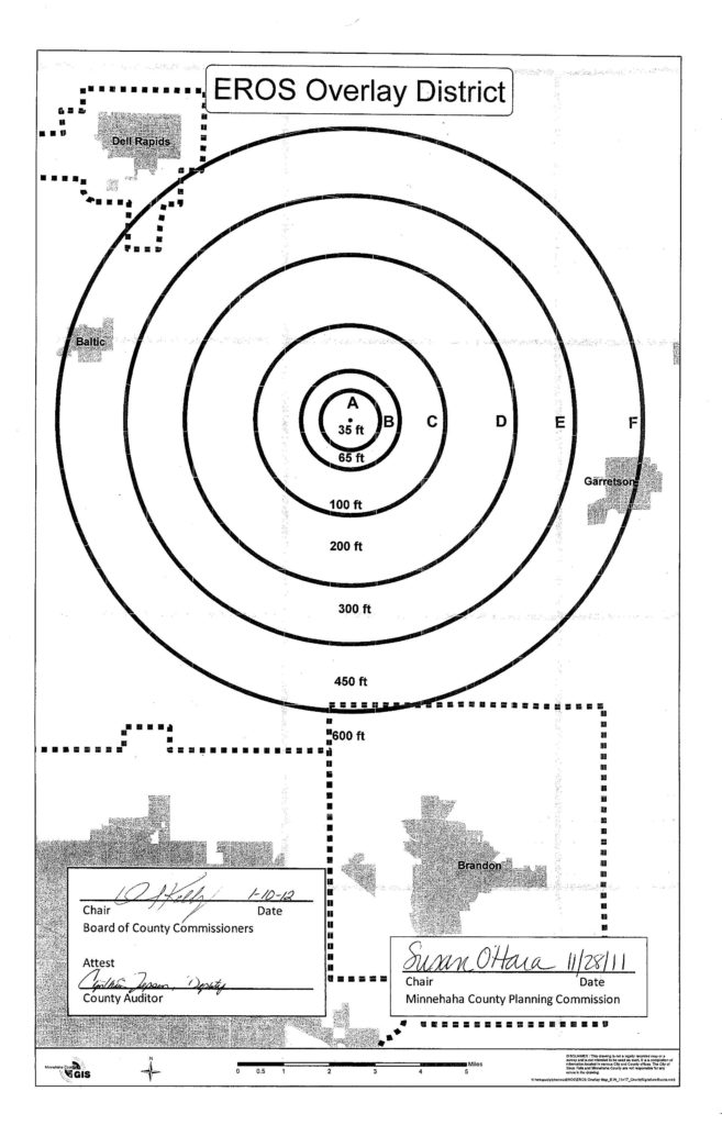
11.50 EO EROS OVERLAY DISTRICT

(approved 1/10/12 MC28-15-12)

11.50.01 INTENT. This district is intended to preserve a clear line of sight for satellite operations at the Earth Resources Observation and Science (EROS) Center. Restrictions shall apply to land use activities which have the potential to interfere with the Center’s ability to support satellite missions.

The EROS Overlay District is superimposed on all zoning districts established by this ordinance. It is not intended that these regulations interfere with, abrogate, or annul any other rules or regulations of this ordinance, except that if the EROS Overlay District imposes a greater restriction than the underlying zoning district regulations, they shall control.

11.50.02 BOUNDARIES OF DISTRICT. The boundaries of the EROS Overlay District are shown upon the map which has been made a part hereof by reference. The map shall have the same force and effect as if it were set forth herein. A copy of the map is on file with the Register of Deeds.

11.50.03 HEIGHT RESTIRCTIONS.
Area A. No structure shall exceed 35 feet in height, as measured from ground level.
Area B. No structure shall exceed 65 feet in height, as measured from ground level.
Area C. No structure shall exceed 100 feet in height, as measured from ground level.
Area D. No structure shall exceed 200 feet in height, as measured from ground level.
Area E. No structure shall exceed 300 feet in height, as measured from ground level.
Area F. No structure shall exceed 450 feet in height, as measured from ground level.

11.50.04 VARIANCE. Application for a variance may be made to the Zoning Board of Adjustment as outlined in Article 21.00 of this ordinance.

11.50.05 GENERAL REGULATIONS. Where the regulations of EROS Overlay District and any other rules and regulations conflict or overlap, whichever imposes the more stringent restrictions shall prevail.

11.50.06 NOTIFICATION. EROS Data Center shall be noticed by certified mail of all height variance applications within boundaries of the EROS Overlay District. Notification shall be made by the applicant and proof of mailing submitted to the Planning Department prior to the Zoning Board of Adjustment meeting.

EROS Overlay District

12.00 ADDITIONAL USE REGULATIONS

12.01 FENCES. Regulations regarding fences shall be as follows:

(A). Fences up to four feet in height may be located on any part of the lot except that such a fence may not be more than 30 percent solid if located within 30 feet of a street intersection, measuring along the property line.
(B). Fences up to six feet in height may be erected on those parts of a lot that are as far back or farther back from the street than the main building.
EXCEPTION: Fences up to six feet in height may be placed in the side-street-side front yard where:

(1). The side-street-side front yard abuts an arterial street shown on the major street plan.
(2). The side-street-side front yard is not adjacent to a side yard.
(3). The fence is located no closer to the front yard than the rear wall of the main building.

12.02 WIND ENERGY CONVERSION SYSTEMS. The regulations regarding Wind Energy Conversion Systems (hereafter referred to as WECS) shall be as follows:

(A). Limited use. No WECS installed in accordance with the requirements of these regulations shall generate power as a commercial enterprise as defined by the Public Utility Commission.
(B). Setback requirements. The minimum distance between the property line, overhead utility lines or another wind turban, and any tower support base of a WECS shall be equal to the proposed tower height (plus the radius of the rotor for the horizontal access machines). Contiguous property owners and planned developments may construct a WECS for their use in common. If property held by more than one single owner is used to meet the setback requirements, a site plan establishing easements or reserved areas must be submitted to the Planning Commissions for their approval.
(C). Tower access. Climbing access to the WECS tower shall be limited either by means of a fence six feet high around the tower base with a locking portal, or by limiting tower climbing apparatus so there is access to it no lower than 12 feet from the ground.
(D). Electromagnetic interference. If a WECS is installed in any location along or within the major access of an existing microwave communications link, the person desiring to install the WECS shall be required to provide a letter from the business whose link they are within or adjacent to stating that the business whose link is affected would have no objection to the installation of the WECS.
(E). Air space. A WECS shall be located or installed in compliance with the guidelines of the Federal Aviation Administration Regulations with regard to Airport Approach Zones and clearance around VOR stations.
(F). Interconnect. The WECS, if interconnected to an electric utility distribution system, shall meet the interconnect requirements of the electric utility company.

12.03 HOME OCCUPATIONS. It is deemed appropriate to allow limited nonresidential activities to operate in conjunction with a residence in those zoning districts where residential dwellings are permitted, provided the regulations protect the character and integrity of the unincorporated area.

The objective of these regulations is to allow limited commercial type activities associated with a residence only to the extent that the activity is clearly subordinate to the residential or agricultural use of the property. Uses such as motor vehicle repair or body shop, motor vehicle sales, recycling center, retail business or similar type uses shall not be considered a home occupation. Due to the diverse pattern of development in the rural area, the regulations provide for both minor and major home occupations.

12.0301 Minor Home Occupation. In all zoning districts permitting residential dwellings, minor home occupations in compliance with each of the following standards are permitted as accessory uses. Due to their incidental and residential nature, minor home occupations are relatively common accessory uses which are not easily detectable and are not reasonable or desirable to regulate through a conditional use permit.

1) The occupation shall be conducted entirely within a dwelling and clearly incidental to the use of the structure for residential purposes.
2) There shall be no change in the outside appearance of the dwelling or any visible evidence of the conduct of the occupation.
3) Only residents of the dwelling shall be employed by or participate in the occupation.
4) The storage of equipment, vehicles, or supplies associated with the occupation shall not occur outside the dwelling. Accessory buildings or structures shall not be used for storage.
5) There shall be no display of products visible in any manner when viewed from outside the dwelling.
6) No advertising or display signs shall be permitted other than a nameplate attached to the dwelling. The nameplate shall not be illuminated and shall not be more than two square feet in area. No off premise signs shall be used.
7) The occupation shall not require internal alterations or involve construction features not customary in a dwelling. External alterations intended to create a separate entrance or other feature exclusively for the occupation is prohibited.
8) There shall be only limited and incidental sale of products conducted on the premise.
9) The occupation shall not generate more than four (4) visits per day from clients or customers averaged over a period of seven (7) consecutive days.
10) The occupation shall not result in additional off-street parking spaces for clients or customers.
11) Toxic, explosive, flammable, combustible, corrosive, radioactive or other restricted materials are prohibited.
12) No equipment or process shall be used in the occupation which creates noise, vibration, glare, fumes, or odor detectable to the normal senses off the property.
13) No equipment or process shall be used in the occupation which creates visual or audible electrical interference in any radio or television receiver or causes fluctuations in line voltage off the property.
14) The number of deliveries generated by the occupation shall not significantly affect the character of the area. Delivery vehicles shall be limited to auto, pick up, or typical delivery service truck.

12.0302 Major Home Occupation. It is recognized that home occupations which exceed the requirements of Section 12.0301 may be appropriate in a low density residential setting or if associated with an agricultural use. For the purpose of this ordinance, such uses are classified as either a Class 1 or Class 2 major home occupation, and shall be evaluated giving consideration to the following criteria:

(A) Class 1:

(1) The occupation shall be conducted entirely within a dwelling or accessory building and clearly incidental to the use of the structure for residential purposes.
(2) The occupation shall be operated by a member of the family residing in the dwelling.
(3) Employees of the occupation shall be limited to residents of the dwelling and up to two (2) non-resident employees, not to exceed four (4) employees on site.
(4) In addition to the dwelling, up to 750 square feet of accessory building space may be used for the occupation.
(5) The occupation shall not create noise which, when measured off the property, exceeds 60 decibels between the hours of 8:00 a.m. and 6:00 p.m. The occupation shall not create noise which is detectable to the normal sensory perception off the property
between the hours of 6:00 p.m. and 8:00 a.m. These off the property noise standards shall not apply to public and railroad rights-of-way.
(6) The occupation shall not create vibration, glare, fumes, odor, or electrical interference detectable to the normal senses off the property.
(7) No outside storage, display of goods or merchandise, or external evidence of the occupation shall occur except as outlined in this section.
(8) A non-illuminated nameplate not exceeding two square feet in area may be placed on the dwelling or accessory building. Additionally, one non-illuminated sign not exceeding four square feet in area may be located along the driveway for the occupation. No off premise signs shall be used.
(9) The occupation shall not generate more than 10 visits per day from clients or customers averaged over a period of seven (7) consecutive days.
(10) There shall be only limited and incidental sale of products conducted on the premise.
(11) The number of deliveries generated by the occupation shall not significantly affect the character of the area. Delivery vehicles shall be limited to auto, pick up, or typical delivery service truck.

(B) Class 2:

(1) The occupation shall be conducted in a dwelling or agricultural building accessory to the dwelling which comprise the headquarters for the agricultural use, and such agricultural use is conducted on one or more parcels of land with a total area of at
least one-half of a quarter section or equivalent area which must be contiguous to or in close proximity to the headquarters.
(2) The occupation shall be clearly secondary to the principal use of the land for agricultural purposes.
(3) The owner or occupant of the dwelling shall be engaged in the occupation.
(4) The occupation shall have no more than five (5) employees, including residents of the property.
(5) The occupation shall be conducted within a completely enclosed building typical of farm buildings. Such building shall be located behind the dwelling, or shall be located at least 200 feet from the nearest road right-of-way.
(6) All materials, supplies and products associated with the occupation shall be stored within a building or if open storage of materials or equipment is required it shall be concealed with appropriate screening or landscaping.
(7) A non-illuminated nameplate not exceeding two square feet in area may be placed on the dwelling or agricultural building. Additionally, one non-illuminated sign not exceeding four square feet in area may be located along the driveway for the
occupation. No off premise signs shall be used.
(8) The use shall cease operating when the property is no longer in conformance with Section 12.03.02 (B) (1).

12.0303 Major Home Occupation – Permit Procedure. A conditional use application is required for a major home occupation in accordance with the requirements of Article 19.00. The application shall be evaluated and conditions established using the criteria in Section 12.0302 (A) or (B).

12.04 MINERAL EXPLORATION & DEVELOPMENT. The regulations regarding mineral exploration and development shall be as follows:

(A). Exploration for minerals may be approved by Conditional Use only as long as the following minimum requirements are met:

(1). The applicant shall provide:

(a). A description of the mineral or minerals which are the subject of the exploration.
(b). Maps showing the general area within which the exploration operation will be conducted.
(c). A detailed description of the regional environmental conditions, to include surface land use and vegetation, as well as a detailed description of the area’s geologic formations and hydrology from the best available scientific sources.
(d). Maps indicating the location of the drill sites to the nearest section of land, a technical description of the exploration process, the types of equipment to be used, and the estimated time table for each phase of work and for final completion of the program.
(e). A description of the major environmental impacts upon air quality, water quality and quantity, and land use modification presented by the proposed exploration.
(f). A description of the proposed plan to address the identified environmental impacts to include all measures to be taken to prevent soil erosion, water contamination, air contamination, disruption of the areas ecological balance and any other related hazard to public health and safety.
(g). A plan for reclamation of the land to its original condition after exploration is completed. Measures to be taken for surface reclamation shall take into account the impact on adjacent land uses and natural resources and the proposed future use of the lands explored and adjacent lands. The reclamation plans include :

— reclamation schedule
— methods of plugging drill holes
— methods of severing and returning topsoil and subsoil.
— methods of grading, backfilling and contouring of exploration sites and access roads
— methods of waste management and disposal, including liquid and solid wastes
— methods of revegetation

(h). A surety performance bond in an amount to be determined by the City and County Commissions to assure that sufficient funds will be available to carry out required reclamation and, if necessary, decontamination of the affected ground and surface waters. The amount shall be set by the City and County Commissions based on an estimate of the cost of reclamation and decontamination. The bond shall be released five years after exploration has ceased unless the Commissioners find for good cause shown, that the water quality of the affected area has not been restored or the reclamation plan has not been completed. The amount of the surety bond may be reduced by the commissioners, if a bond is held by the State of South Dakota for the same purpose, by the same amount of the latter bond.

(2). The applicant shall identify specific phases when monitoring and inspection of the exploration activities shall be conducted by city, county, state, federal or independent personnel to assure compliance with all applicable rules and regulations. If a conditional use permit is granted, the permit shall identify such inspection agency and it shall be the responsibility of the applicant to notify said agency when monitoring or inspection is required. The applicant shall bear the burden of the cost of the monitoring and inspection program as determined by the Commissioners.

(3). A Conditional Use shall be issued only after all of the conditions specified herein have been met. Evidence of violation of the regulations, including but not limited to air and water contamination, shall be cause for an immediate cessation of exploration activities.

(B). Mineral extraction and/or mining may be approved by Conditional Use only as long as the following minimum requirements are met:

(1). The Applicant shall provide:

(a). A description of the mineral or minerals to be mined or milled.
(b). Maps showing the area within which the mining or milling operations will be conducted.
(c). A description of the surface land use and vegetation, as well as a description of the nature and depth of the top soil and subsoil.
(d). An environmental assessment which establishes base line conditions for radioactive intoxicant materials and air, ground and surface waters, soils, vegetation and animals.
(e). A description of the overburden, mineral seams, and other geologic formations, their conductivities and hydraulic gradients, known to exist above the deepest projected depth of the mining operation.
(f). A description of the hydrology to the deepest projected depth of the mining operation, including mapping of the depth, water table level, extent, and flow characteristics of ground water and aquifers for the hydrologic regime of the ground water and drainage basins affected by the mining or milling operation.
(g). A technical description of the mining or milling, types of equipment to be used, detailed site plan of all anticipated construction, an estimated timetable for each phase of work and for final completion of the program, a statement of source, quality, and quantity of water to be used in the mining or milling operations, as well as the chemical and radioactive characteristics of all mined or milled products, waste products, and emissions to the environment.
(h). A description of the major environmental impacts upon air quality, water quality and quantity, and land use modification presented by the mining or milling operations.
(i). A description of the proposed plan to address the identified environmental impacts to include:

— methods of separating the topsoil, subsoil, and soil piles, protecting them from erosion before reclamation begins, and keeping the topsoil free from acid or toxic materials
— plan for insuring that acid forming or toxic materials constituting a hazard uncovered or created during mining or milling are promptly treated in a manner to prevent water and air contamination
— measures to maintain the quantity and quality of ground and surface water, hydrologic balance, productivity of farmland, and soil and water recharge capacity
— procedures to prevent water and air contamination through radioactive or toxic seepage of runoff from tailings, ponds, mine wastes, mine dewatering discharge, or other mining and milling related operations.

(j). A plan for the reclamation of the land after mining is completed. Measures to be taken for surface reclamation shall take into account the impact on adjacent land uses and natural resources, and the proposed future use of the lands mined and adjacent lands, and shall include:

— a reclamation schedule
— methods of grading, backfilling and contouring of disturbed areas and access roads.
— methods of waste management and disposal, including liquid and solid wastes
— methods of revegetation.

(k). A surety performance bond in an amount to be determined by the City and County Commissions to assure that sufficient funds will be available to carry out required reclamation and, if necessary, decontamination of affected ground and surface waters. The amount shall be set by the City and County Commissions based on an estimate of the cost of reclamation and decontamination. The bond shall be released five years after mining and milling has ceased unless the Commissioners find, for good cause shown, that the water quality of the affected area has not been restored or the reclamation plan has not been completed. The amount of the bond may be reduced by the Commissioners if a bond is held by the State of South Dakota for the same purpose, by the same amount of the latter bond.

(2). The applicant shall identify specific phases when monitoring and inspection of the mining and milling process shall be conducted by city, county, state, federal or independent personnel to assure compliance with all applicable rules and regulations. If the Conditional Use is granted, the permit shall identify the inspection agency and it shall be the responsibility of the applicant to notify said  agency when monitoring or inspection is required. The applicant shall bear the burden of the cost of the monitoring and inspection program as determined by the Commissioners.
(3). A Conditional Use shall be issued only after all conditions specified therein have been met. Evidence of violation of the regulations, including but not limited to air and water contamination, shall be cause for an immediate cessation of the mining
and milling.

(C). Solution mining and/or in situ mining of an ore body with the circulation of chemicals through injection and recovery wells for minerals is prohibited.

12.05 [Reserved.]

12.06 MOBILE HOMES/MANUFACTURED HOMES. Regulations regarding mobile homes and manufactured homes shall be as follows:

(A). A park intended for the placement of mobile homes and manufactured homes on rented lots and where the roads are not publicly dedicated shall meet the following minimum standards:

(1). A plan shall be prepared showing the layout of the park, including lot lines, the road system and spacing diagram for all structures. Upon approval of the conditional use for the park, the plan shall be filed in the Office of Planning and Zoning and govern all future development.
(2). Each lot shall have a minimum size required for the zoning district in which the park is located. However, a smaller lot size may be approved as part of the conditional use.
(3). No dwelling or any structure, addition, or appurtenance thereto shall be located less than the minimum setback required by the district in which the park is located. The setback requirements may be changed as part of the approval of the conditional use.
(4). Each lot shall abut or face a clear unoccupied space, roadway, or street having a width of at least 34 feet where parking is permitted on both sides, 27 feet in width where parking is restricted to one side only and 24 feet wide where parking is prohibited, or be connected to such street or roadway by a private driveway not less then 12 feet in width, serving no more than four lots. A hard surfaced material shall be used on all roadways except in the RR District, in which case gravel may be used.
(5). The park shall be a minimum of 10 acres in size.

(B). A subdivision for mobile homes and manufactured homes shall be required to meet the subdivision regulations and the density, area and yard requirements for the district in which it is located. The subdivision shall be a minimum of 10 acres in size.
(C). A manufactured home may be considered for a conditional use as specified in the district regulations only if the following requirements are met:

(1). The structure shall have been constructed on or after July 15, 1976.
(2). The exterior dimensions of the structure, measured by excluding overhangs, shall not be less than 22 feet.
(3). The structure shall be supported by a foundation system consisting of walls along the perimeter and piers on the interior. All foundation walls and piers shall extend a minimum of 42 inches below final grade.
(4). The roofing and siding material shall be consistent with the material used in site built dwellings.
(5). The roof pitch shall not be less than a 3 in 12 slope.

(D). Mobile homes which are nonconforming uses may be replaced with another such structure by making application for a conditional use. The compatibility of the replacement dwelling with neighboring dwellings shall be considered in reviewing the conditional use request.
(E). A mobile home or manufactured dwelling may be located temporarily on land owned by the occupant during the construction of a dwelling. Placement shall not occur until construction has actually commenced. The unit shall be removed after one year or upon completion of the dwelling, whichever occurs first.
(F). All mobile homes and manufactured homes as defined in Article 26.00 must be located in conformance with these requirements.

12.07 ACCESSORY BUILDING AND USES. The regulations regarding accessory buildings and uses shall be as follows:

(A). Limited Use. Accessory buildings and uses are buildings and uses customarily incident to any of the permitted uses in the district in which it is located. In the A-1, RC, RR, R-1, and RR-5 districts, accessory buildings and uses are limited to:

(1). A noncommercial greenhouse that does not exceed in floor area 25 percent of the ground floor area on the main building.
(2). A private residential garage used only for the storage of noncommercial vehicles and other related material.
(3). Tennis court, swimming pool, garden house, pergola, ornamental gate, barbeque oven, fireplace, and similar uses customarily accessory to residential uses.
(4) Home occupation in conformance with Section 12.03.
(5) Temporary storage and distribution of seed and similar type products provided the use is located within a farmstead, the product is stored within a completely enclosed building typical of farm buildings and the use is limited to the seasonal sale of products from the premises.

(B). Time of Construction. No accessory buildings shall be constructed upon a lot until the construction of a main building has been actually commenced, and no accessory buildings shall be used unless the main building on the lot is also being used. Accessory buildings may not be used for dwelling purposes.
(C). Setback Requirements.

(1). Accessory buildings which are attached to or located within 10 feet of the main building shall be considered a part of the main building and shall comply with the same yard requirements as the main building.
(2). Accessory buildings not a part of the main building, when located in the required rear yard, shall be no closer than three feet to the side and rear property lines.

(D). Accessory buildings shall not occupy more than thirty (30) percent of the rear yard, subject further to the following limitations (amended by Ordinance MC28-17-18):

(1) In the A-1 and RC Districts, the total area of accessory buildings shall be limited based on the size of the parcel as depicted in Table 1 unless a conditional use has been approved.
(2) In all Residential Districts, the total area of accessory buildings shall be limited based on the size of the parcel as depicted in Table 1 unless a conditional use has been approved.
(3) In a Planned Development District, the total area of accessory buildings shall be limited based on the size of the parcel as depicted in Table 1 unless a minor amendment has been approved.

TABLE 1: Total Permissible Area of Accessory Buildings
Size of Parcel in Area
Permissible Area of Accessory Building Footprint
1.00 acres or less
1,600 Square Feet
1.01 to 3.00 acres
2,400 Square Feet
3.01 acres or more
3,600 Square Feet

12.08 ROCK, SAND AND GRAVEL EXTRACTION

(A). Intent.
This section addresses the application, review and regulation of extraction and on-site processing of rock, sand and gravel. An applicant must meet certain requirements as specified in Subsection C when filing for a conditional use in addition to the general
requirements contained in other sections of the zoning regulations.

The developmental and operational criteria contained in Subsection G are intended to assist in the formulation of conditions to be imposed on individual extraction operations. The criteria have been designed to eliminate potential health risks and minimize the
adverse impact on other land uses due to extraction operations.

The County and City will have the discretion of requiring more or less stringent conditions based upon the location of a proposed operation. It is also recognized that such operations will not be appropriate throughout all areas of the joint zoning jurisdiction. (amended by MC28-01-03)

(B). Submission of Application.
The application for rock, sand or gravel extraction shall be filed with the Planning Office on the prescribed conditional use form at least 30 days in advance of a regularly scheduled joint meeting of the Planning Commissions.

(C). Application.
The conditional use application shall be accompanied by the following:

(1). Maps showing the area within which the extraction operations will be conducted, including areas to be disturbed, setbacks from property lines, and the location of all structures, equipment and access and haul roads.
(2). A description of the surface land use and vegetation, including all pertinent physical characteristics.
(3). A hydrologic study which shall include all available information from the State Geological Survey and other information pertinent to the application. If the applicant believes a study is not warranted, documentation shall accompany the application in support of this position.
(4). A reclamation plan which takes into consideration the criteria listed in Subsection G – reclamation.
(5). The applicant shall meet with the township supervisors of the affected township to discuss repair and maintenance responsibilities on township roads to be used as haul routes. A summary of the meeting(s) shall be presented with the application.

(D). Fee.
If a conditional use is granted, the operator shall pay to the County an annual fee of $10 per acre of land which is being disturbed by the extraction activities and has not been reclaimed. The fee shall be used to defray the direct and indirect costs associated with
general administration and enforcement of this section. The fee shall be payable by January 20th of each year and deposited in the general fund of the County. The disturbed land area existing on January 1 of each year shall be used in calculating the fee.
(E). Notification Requirements.
In addition to the notification requirements of Article XXII Section 4(B), the Planning Director shall notify by U.S. mail all property owners of record within one mile of the proposed conditional use area or the owners of the thirty properties nearest to the  affected property, whichever affects the least number of owners, of the time, date, place and purpose of the public hearing. The notice shall be mailed not less than 15 days prior to the public hearing.
(F). [Reserved.]
(G). Developmental and Operational Criteria.
The following criteria shall be considered in developing conditions for applications involving rock, sand and gravel extractions. More stringent requirements may be imposed by the County and City or the applicant may present arguments to relax the requirements based on specific characteristics of the site.

Buffer Area.
(1). A minimum distance of 1000 feet should be maintained between an existing residence and a rock, sand or gravel operation, except in those instances when the operator secures a waiver from the affected landowner.
Hours of Operation.

(1). Monday thru Friday – 7:00 A.M. to 6:00 P.M., Saturday – 8:00 A.M. to 12:00 noon. Operations should not be conducted on legal holidays. Activities such as office or maintenance operations which produce no noise off-site should not be restricted by the hours of operation.
(2). Blasting should be scheduled on weekdays at 12:00 noon. There should be no blasting on legal holidays. Area residents should be notified of the date and time of each blast.

Visual Considerations.
(1). Earth berms and vegetation should be employed to minimize visual impacts and reduce the effects of noise.
(2). The need for and placement of berms should be determined by the orientation and position of the excavation site with respect to residences and roadways. Berms should be located in such a way as to restrict the public’s view of the property.
Consideration should be given to placing the berms as close to the public point of view as practical. Generally, berms should be six feet in height and seeded immediately after construction to avoid soil erosion. Berms should be maintained
and kept reasonably free of weeds.
(3). The operator should work with the County Conservation District and Planning Director to develop a planting program. Consideration should be given to planting one or more of the following: evergreen, Russian olive, ash, caragana, crab apple, lilac and buffalo berry. The plants should be properly cared for to ensure the highest survival rate and all dead plants replaced during the current planting season. As a minimum, the program should include trees of varying maturity. The planting program should be reduced to writing and kept on file in the Planning Office.
(4). At a minimum, berms should be constructed prior to blasting or the extraction of rock, sand or gravel.

Blasting.
(1). Ground vibration and over pressure (air blast) should be monitored for each blast and not exceed guidelines established by the U. S. Bureau of Mines.

Noise.
(1). The noise level produced from rock, sand and gravel operations should not exceed an average of 55 decibels recorded over a 10 minute period measured at the nearest existing residence to the extraction operation. Off-site activities which contribute to background noise levels should be taken into consideration when monitoring an operation. Blasting should not be recorded as part of the noise level.

Air Quality.
(1). Air quality monitoring should be conducted at the operator’s expense when conditions warrant.
(2). Ambient air quality: total suspended particulate matter – 150 micrograms per cubic meter of air as a 24-hour average not to be exceeded more than once per year, and 60 micrograms per cubic meter of air as an arithmetic mean; PM10 (10 micrometers or less in size) consistent with the regulations of the State of South Dakota.
(3). Employ techniques that minimize the release of particulate matter created by material stockpiles, vehicular movement and process operations.
(4). Dust control agents should be applied to township gravel roads designated as haul routes and all driving surfaces within the extraction area.

Hydrology, Dewatering and Drainage.
(1). Existing wells should be monitored at the operator’s expense to document changes in hydrologic conditions around extraction sites.
(2). Dewatering of the extraction site should not result in downstream flooding.
(3). Berms should not interrupt the natural drainage of the area, unless such diversion is part of an approved drainage control system.

Haul Roads.
(1). In order to minimize the negative impact of truck traffic on area residents, extraction operations should be located on or near existing hard surfaced roads. Consideration should be given to the number of residents located along gravel surfaced roads intended for use as haul roads.
(2). Identify repair and maintenance responsibilities through a haul road agreement.
(3). Consider the potential impact on County highways to be used as haul routes.

Operator Surety.
(1). A surety performance bond may be required in an amount to be determined by the Planning Commissions to assure that sufficient funds will be available to protect the County and City in the event the operator abandons a site without completing the conditions imposed by the conditional use, including fulfillment of the agreement with the township concerning repair of designated haul roads and, if necessary, decontamination of affected ground and surface waters. In lieu of the required surety, the operator may deposit cash with the County in the amount equal to the required surety.

Reclamation.
(1). The type and extent of reclamation should be based on the type of material extracted on the intended post-mining land use, but in all cases the reclamation procedures should result in the rehabilitation of affected land through contouring and soil stabilization, revegetation and other appropriate means so as to create the least amount of unsightliness and most appropriate future use of the reclaimed area. Bodies of water may be incorporated into an acceptable reclamation plan.
(2). Provide maps, including cross sections, showing the existing natural topography and anticipated topographic conditions upon completion of reclamation.
(3). Grading should achieve a contour that is most beneficial to the proposed future land use. All berms should be removed where sand and gravel operations were conducted. In most cases involving quarry operations, the berms should remain in place unless their removal would serve a more useful purpose.
(4). Topsoil should remain on site and be used during reclamation.
(5). A seeding and revegetation plan should be developed for the affected area in consultation with the County Conservation District.
(6). All required reclamation activities should be completed and a compliance inspection performed by the County Planning Director prior to the release of the surety.

Additional Considerations.
(1). The maximum height of a bench in a quarry should be 30 feet.
(2). The property should be secured during non-working hours by means of gates and fencing. The property should continue to be secured until all required reclamation activities have been completed.

12.09 ADULT USES. In the development and execution of this ordinance, it is recognized that there are some uses which, because of their very nature, are recognized as having serious objectionable operational characteristics, and are not compatible with certain uses. Special regulation of these uses is necessary to ensure that these adverse effects will not contribute to the blighting or downgrading of the surrounding area.

(A). None of the following uses may be established, operated, or maintained within five hundred (500) feet of a residential dwelling, a residential district, a church, a school meeting all the requirements of the Compulsory Education Laws of the State of South
Dakota, or a public park, as measured from the closest point of the property lines.

1. Adult bookstore
2. Adult theater
3. Adult photo studio
4. Adult mini motion picture theater
5. Adult amusement or entertainment establishment

12.10 CONCENTRATED ANIMAL FEEDING OPERATIONS

(A). Intent.
It is the intent of this section to provide for a viable livestock industry within agriculturally zoned areas of the joint zoning jurisdiction, protect ground and surface waters and ensure that concentrated animal feeding operations are properly sited, maintained and managed. (amended by MC28-01-03)
(B). Water Source Protection Areas.
A concentrated animal feeding operation – new (Class A, B or C) shall not be permitted in the Water Source Protection Overlay District.
(C). Application Procedures and Requirements. (amended by MC28-08-06)
Prior to application submittal the operator of the proposed facility shall meet with the Planning Director to discuss application requirements.
The conditional use application shall be accompanied, at a minimum, by the following information. The geotechnical boring requirement in subsection 3 may be waived if a state general permit is required.

(1). A description of the type of concentrated animal feeding operation and the number of animals proposed for the facility.
(2). A site plan of the proposed facility including:

(a). A landscaping plan designed to assist in the dispersal of odors.
(b). A grading plan designed to help keep pens and solid waste containment areas dry.

(3). When the site is located within a designated water source protection area or over a mapped shallow aquifer area a geotechnical test boring log recording the geological data of at least one deep subsurface boring shall be required. This boring must be located below the location of the proposed containment facility and extend to a minimum of 25 feet below the ground surface and may stop when one of the following criteria has been met:

(a). At least 15 continuous feet of extremely low permeability geologic material such as unweathered clayey till or shale is encountered in the boring;
(b). At least 30 continuous feet of low to extremely low permeability weathered or unweathered till or shale is encountered;
(c). The boring reaches an aquifer; or
(d). A total depth of 100 feet is reached.

(4). A pest, odor control and dead animal disposal plan.

(D). Notification Requirements.
In addition to the requirements of Section 19.05 (A), the County Planning Director shall notify by U.S. mail all property owners of record within one-half mile of the proposed concentrated animal feeding operation of the time, date, place and purpose of the public hearing. Such notification shall occur at least fifteen days prior to the hearing.
(E). Conditional Use Permit Requirements. (amended by MC28-08-06)
A concentrated animal feeding operation which is granted a conditional use permit shall, at a minimum, meet the following requirements:

(1). When a state permit is required. The operator shall file copies of all state approved construction plans with the County.
(2). Record Keeping. The operator shall maintain inspection and maintenance records on the animal waste facilities, and records on compliance with the waste and nutrient management plan and odor and pest control plan.
Copies of records shall be filed annually with the County.
(3). Waste Application. All liquid wastes shall be injected to provide for better agronomic benefits and to reduce the potential for runoff and minimize odor.

(a). In the event that an extraordinary circumstance requires surface application of liquid waste, the following information shall be submitted to the Planning Office: a description of the extraordinary circumstance which requires surface application; a map showing the proposed application sites along with soil types, slopes, and the required separations from natural features or adjoining land uses: the minimum volume of waste which will have to be applied in order to provide relief:
and the means by which the waste will be applied. The Planning Director may authorize the surface application of liquid waste under the following minimum conditions:

(1). Waste shall not be surfaced applied on frozen ground with slopes of greater than 4 percent.
(2). Only the minimum amount of waste necessary to provide relief shall be surface applied.
(3). The separation requirements in Table 3, Section 12.10 (G) shall be met.

(b). The Planning Director may approve surface application of livestock production surplus water upon receiving an application from the producer. Such application shall include:

(1). The results of tests on the livestock production surplus water proposed for surface application which shows the percentage of solids and the amount of N (nitrogen) per 1000 gallons of water.
(2). The amount of livestock production surplus water to be applied.
(3) A map showing the areas on which the producer proposes to surface apply the livestock production surplus water including soil types, slopes, and the required separations from natural features or adjoining land uses.
(4) The separation requirements in Table 3, Section 12.10 (G) shall be met.
(4). Shallow Aquifer. If the geotechnical test boring shows the area to be over a shallow aquifer, then measures shall be employed to protect the groundwater. The County may call upon the expertise of the South Dakota Geological Survey in making a determination on whether a shallow aquifer exists on the site.
(5). Inspections. A registered professional engineer shall inspect the facility during construction and certify to the County that the newly constructed facility conforms with the approved plans and with South Dakota Department of Environment and Natural Resources design standards.
(6). If required by the South Dakota Department of Environment and Natural Resources or as a condition of the conditional use permit the operation shall obtain a State General Water Pollution Control Permit for Concentrated Swine Feeding Operations or for Concentrated Animal Feeding Operations.
(7).A nutrient management plan for liquid and solid waste including:

(a). Location and description of the animal waste facilities and structures.
(b). Operational procedures and maintenance of the animal waste facilities.
(c). Description of the proposed method for animal waste application.
(d). Map showing distances from proposed animal waste application sites to natural features and land uses as shown in Table 3.
(e). Information showing the application of waste based on agronomic rates computed from the types of crops and estimated yields on the application sites, the available nutrients in the application site soils and the available nutrients in the waste.
(f). Waste application agreements shall be required if the petitioner does not own the minimum acreage required to apply the animal 
waste produced by the facility.

(F). Separation Requirements and Criteria for Concentrated Animal Feeding Operations.
A concentrated animal feeding operation shall comply with the minimum separation requirements in Table 1.

Table 1 Concentrated Animal Feeding Operations Minimum Separation Requirements
Class A
Class B
Class C
Class D
Public Water Supplies
1,000 feet
1,000 feet
1000 feet
500 feet
Private Wells (other than owner's or operator's)
250 feet
250 feet
250 feet
250 feet
Private Wells (owner's or operator's)
150 feet
150 feet
150 feet
150 feet
Lakes, Rivers and Streams Classified as Fisheries
500 feet
200 feet
200 feet
200 feet
Intermittent Streams or waterways
100 feet
100 feet
100 feet
100 feet

The minimum separation criteria in Table 2 shall be used in siting a concentrated animal feeding operation. The minimum separation criteria may be increased based on site specific conditions. When a proposed operation does not meet the minimum separation
criteria, the application shall be accompanied by one of the following or a combination thereof:

1) A signed waiver from each landowner located closer than the minimum separation criteria. No building permit shall be issued until the waivers are filed with the County Register of Deeds.
2) In the absence of a waiver, documentation shall be presented on new technology, management practices, topographic features, soil conditions or other factors which substantiate a reduction in the minimum separation criteria.

Table 2 Concentrated Animal Feeding Operations Minimum Separation Criteria
Class A
Class B
Class C
Dwellings, Churches, Schools, and Businesses
4,620 feet plus 880 ft. For each additional 250 AU (or portion thereof) over 2,000 AU
1,980 feet plus 660 ft. For each additional 250 AU (or portion thereof) over 1,000
AU 660 feet plus 440 ft. For each additional 250 AU (or portion thereof) over 250 AU
Public Parks
5,280 feet plus 880 ft. For each additional 250 AU (or portion thereof) over 2,000
AU 2,640 feet plus 660 ft. For each additional 250 AU (or portion thereof) over 1,000
AU 1,320 ft. plus 440 ft. For each additional 250 AU (or portion thereof) over 250 AU
Municipalities
10,560 feet plus 1320 ft. For each additional 250 AU (or portion thereof) over 2,000 AU
5,280 feet plus 1320 ft. For each additional 250 AU (or portion thereof) over 1,000 AU
2,640 ft. plus 880 ft. For each additional 250 AU (or portion thereof) over 250 AU

(G). Separation Requirements for Animal Waste Application Sites.
The minimum separation requirements in Table 3 shall apply to the application of animal wastefrom a concentrated animal feeding operation.

Table 3 Animal Waste Application Sites Minimum Separation Requirements
Animal Waste, Surface Applied
Animal Waste, Incorporated or Injected
Lakes, Rivers and Streams Classified as Fisheries
300 feet
100 feet (lake) 50 feet (river or stream)
Streams and Lakes Classified as Drinking Water Supplies
1,000 feet
300 feet
Intermittent Stream or Waterway
200 feet
50 feet
Public Wells
1,000 feet
1,000 feet
Private Wells
250 feet
250 feet
Residence (other than operator)
300 feet (surface)
50 feet
Municipalities
1,000 feet
300 feet

The application of liquid animal waste by irrigation shall be prohibited. The County Planning Director, however, may approve the surface application of livestock production surplus water in accordance with Section 12.10 (E)(3).

12.11 TEMPORARY USES

(A) Intent. The requirements of this section are intended to provide for the regulation and permitting of uses and associated improvements on private property which are not so recurring in nature as to constitute a permanent use. These requirements are not intended to regulate temporary uses on public property, including public rights-of-way.
(B) Permit Required. No person shall operate a temporary use without first obtaining a permit therefor from the County Planning Department as prescribed in this section. If an objection is filed pursuant to Section 12.11 (E) or if the County Planning Department
determines that a hearing should be held due to the scope of the proposed use, the County Planning Department shall refer the temporary use application to a joint meeting of the City and County Planning Commissions for action.
(C) Applications.

1) Submission deadline. All applications for a temporary use permit shall be made at least 60 days prior to the proposed commencement date of the use, provided that the County Planning Department may approve a lesser time consistent with the
requirements of this section.
2) Temporary use plan. All temporary uses shall be subject to approval of a temporary use plan. The plan shall describe the nature and location of all temporary improvements and activities, the location of any permanent buildings intended to be used, the time period for which the temporary use permit is requested, and such other information in sufficient detail as the County Planning Department determines is reasonably necessary to adequately review the application and to ensure the use will be conducted in a manner consistent with the requirements of this section.

(D) Standards for review. The following standards shall be used in determining the suitability and compatibility of a temporary use:

1) The temporary use will have no adverse effect on nearby properties or jeopardize public health, safety, and general welfare.
2) The temporary use will not create hazardous traffic conditions or result in traffic in excess of the capacity of the roads serving the use.
3) The site is adequate to accommodate the proposed use, including the provision for on and off site parking.
4) Adequate sanitation facilities will be available on the site.
5) The time period and hours of operation for the temporary use are clearly specified.
6) Provision is made for the removal, clean-up, and restoration of the site.
7) The temporary use will not adversely impact the natural environment.
8) The site is suitable for the proposed temporary use, considering flood hazard, drainage, soils, and other conditions which may constitute a danger to life, health or property.
9) All temporary improvements and any permanent structures proposed to be used will comply with all applicable provisions of the county=s building code.

(E) Notice. The County Planning Department shall send written notice of the temporary use permit application to the owners of all property located within at least 600 feet of the property involved. Such notice shall be sent at least 14 days before the County Planning Department makes its determination on the temporary use permit. If any of the owners so notified file a written objection prior to the time the County Planning Department makes its determination regarding the application, the application shall be referred to a joint meeting of the County and City Planning Commissions for action.
(F) Conditions of approval. Reasonable conditions may be required in connection with the approval of any temporary use permit which are deemed necessary to protect the public health, safety and welfare and the social and economic well being of those who will use the temporary use, residents and landowners immediately adjacent to the proposed use, and the community as a whole. Any condition imposed must be clearly specified in writing on the temporary use permit.
(G) Appeal of decision. Any person aggrieved by an action of the County Planning Department in granting, denying, revoking, or suspending a temporary use permit may appeal such action to a joint meeting of the County and City Planning Commissions.
Such appeal shall be in writing and filed with the County Planning Department within five working days of the decision. The action of the Planning Commissions may be appealed to the Board of County Commissioners and City Council in the same manner.
(H) Fee. A fee of $250 shall accompany the application for a temporary use permit. (amended by MC28-06-05)
(I) Exemptions. The following uses shall not require a temporary use permit:

1) Estate or real estate sales involving the property or items from the property where the sale is held.
2) Garage, yard or rummage sales provided:

a) Sales last not longer than three (3) days.
b) Sales are held no more than twice yearly.
c) Sales are conducted on the owner’s property or one of the owner’s properties in case of a multi-party sale.

3) Weddings, purely social parties or similar family events where the function or event involves the owner or lessor of the property and where no monetary consideration or fees for such use of the property or attendance is involved.

12.12 TELECOMMUNICATIONS TOWERS, ANTENNA SUPPORT STRUCTURES AND BROADCAST TOWERS. (amended by MC28-01-03)

(A) Intent. Regulations regarding telecommunications towers, antenna support structures and broadcast towers are intended to accommodate the development of a competitive communications and broadcast marketplace while protecting the health, safety, and
welfare of the public and maintaining the aesthetic integrity of the county. The regulations cover the placement, construction, and modification of telecommunications towers, antenna support structures and broadcast towers. The specific intent of this section is to:

(1). Regulate the location of telecommunications towers, antenna support structures and broadcast towers;
(2). Promote and encourage shared use/co-location of telecommunications towers, antenna support structures and broadcast towers;
(3). Avoid potential damage to property caused by telecommunications towers, antenna support structures and broadcast towers by insuring that such structures are soundly and carefully designed, constructed, modified, maintained, and removed when no
longer used or when determined to be structurally unsound;
(4). Insure that telecommunications towers, antenna support structures and broadcast towers are compatible with and do not adversely impact surrounding land uses;
(5). Facilitate the provision of wireless communications services to residents and businesses in an orderly fashion.

(B) Equipment Design.

(1). Antennas shall be mounted on a single monopole or guyed lattice tower.
(2). Towers not requiring FAA painting/marking shall have a galvanized finish or be a neutral color.
(3). Equipment structures shall be a neutral color.

(C) Setbacks/Spacing.

(1). Setbacks shall be measured from the base of the tower to the property line of the parcel on which it is located.
(2). Not withstanding other setback standards in this ordinance the exterior base of a self support lattice, monopole, guyed lattice tower shall be separated from all residential dwellings (not located on the subject property), residential subdivisions,  residential zoning districts, and public parks by a minimum distance of thirteen hundred (1300) feet. Setback requirements may be reduced if written permission is obtained from an impacted property owner.
(3). There shall be a minimum distance of three (3) miles between towers.

(D) Illumination and Security.

(1). Towers shall not be artificially lighted unless required by the FAA. Required safety lighting shall not exceed the FAA minimum. Flashing white lights shall not be allowed for night time lighting.
(2). Security lighting on the site shall not exceed twenty (20) feet in height and be directed toward the ground to reduce light pollution, prevent off site light spillage and avoid illuminating the tower.

(E) Maintenance.

(1). All telecommunications towers, antenna support structures and broadcast towers facilities shall be maintained in good condition, order, and repair so that they do not endanger the life or property of any person.
(2). Telecommunications towers, antenna support structures and broadcast towers shall be maintained in compliance with Telecommunications Industries Association/Electronic Industries Association Standard TIA/EIA 222 (latest revision), all
applicable laws, and so as not to interfere with the use of other property. Upon the Planning Director’s determination that a tower structure is a hazard to public safety, the owner shall be required to perform an inspection by a registered professional
engineer and make all recommended corrections.
(3). If an owner discontinues use of a tower, or if an owner files notice with the Federal Communications Commission of its intent to cease operating the tower, the owner shall give written notice to the Planning Director of the date of such discontinuance.

(F) Signage.

(1). Signage at the site is limited to non-illuminated warning and equipment identification signs.
(2). Sign area shall not exceed six (6) square feet in size.

(G) Co-Location/Shared Facilities.

(1). The tower owner shall not exclude co-location on the same tower when co-location is structurally, technically or otherwise possible.
(2). In addition to equipment proposed for the applicant’s use, proposed towers and sites must be designed to accommodate co-location of a minimum of two additional providers for towers between 100-200 feet and a minimum of three additional
providers for towers over 200 feet in height.
(3). The Planning Director may revoke a building permit when a tower is capable of colocation if:

(i) The tower owner refuses to provide space for other providers at a fair market rate when it would not impair the structural integrity of the tower or cause interference; or
(ii) The tower owner modifies the structure in a way to make co-location impractical or impossible. If a permit is revoked, the facility must be removed at the owner’s expense.

(H) Abandonment.

(1). Towers, antennas and equipment facilities are considered abandoned if they are unused by all providers at the facility for a period of 365 consecutive days. The Planning Director will determine if towers, antennas and equipment facilities have been abandoned. The Planning Director has the right to request documentation from the facility owner regarding tower or antenna usage. Following written notification of a determination that a facility is abandoned, the facility owner has seventy-five (75) days to:

(i) Reuse the facility; or
(ii) Dismantle the facility. If the facility is not removed within seventy-five (75) days of abandonment, the County may remove the facility at the facility and/or property owner’s expense. If the facility is removed, all permits associated with the facility are revoked.

(I). Application Requirements (in addition to standard requirements).
The facility or property owner shall file a letter with the Planning Department accepting responsibility for removal of the tower if it is abandoned.
(J). Technical Issues and Expert Review.
Towers, antennas and equipment facilities may involve complex technical issues that require review and input that is beyond the expertise of County staff. The Planning Director may require the applicant to pay reasonable costs for a third-party technical study
of a proposed facility. Selection of expert(s) to review the proposal will be in at the sole discretion of the County.

12.13 Vehicle & Equipment Restrictions. (Section added by MC28-14-10 4/27/10)

(A). Intent. It is the intent of this section to limit the impact of commercial vehicles and equipment, recreational vehicles, and agricultural vehicles and equipment upon those areas of the county in which the land use is residential or agricultural in nature. Fire, law enforcement, emergency vehicles, and those vehicles designed for persons with disability are exempt from this section of the ordinance. 
Section 12.13 shall apply to the Agricultural, Recreation/Conservation, and Residential zoning districts. Commercial vehicles, agricultural vehicles, recreational vehicles, and equipment are prohibited unless in compliance with Section 12.13.
(B). Commercial Vehicles and Equipment. It is not the purpose of the section to prohibit commercial vehicles as described herein from residential parcels when actually engaged in a business activity which requires their presence for a specific purpose and limited time period.

1. One commercial vehicle per resident, not to exceed a maximum of two commercial vehicles, shall be permitted on a property with an occupied residence provided that:

a. In a residential development area, the vehicle shall be currently licensed, fully functional, and have a gross vehicle weight of 12,000 pounds or less and not exceed 22 feet in length. Exclusive of a residential development area, the vehicle shall be currently licensed, fully functional and have a gross vehicle weight of 26,000 pounds or less and not exceed 22 feet in length.
b. A semi-tractor is exempt from the gross vehicle weight requirement for Section(B)1a.
c. The vehicle shall be operated by a person residing on the premises, and shall provide primary transportation for the resident to and from their place of employment.
d. The vehicle shall not be parked or stored within the right-of-way.
e. No attached vehicle, trailer or equipment shall be allowed.

2. Commercial vehicles and equipment that are currently licensed (if required) and fully functional and are in use as part of a permitted construction project shall be allowed for the duration of the said project. Should the construction project cease for period of six(6) months, the commercial vehicles and equipment shall be removed from the property. Commercial vehicles and equipment shall not be stored or parked for longer than seventy-two (72) hours upon any right-of-way.
3. Commercial equipment that is fully functional, owned by the resident, and used by the resident for regular or ongoing maintenance of the property (i.e. lawn care, driveway maintenance, snow removal) and not for profit, shall be allowed on properties used for residential and agricultural uses.
4. Commercial vehicles or equipment shall not be used for human or animal occupancy.
Semi –trailers shall not be used for storage.

(C). Recreational Vehicles and Equipment.

1. The parking and storage of recreational vehicles shall be allowed provided that:

a. The vehicle title holder for any and all recreation vehicles parked or stored on the property shall be the property owner or permanent resident of the dwelling, or
b. If the property owner or permanent resident of the dwelling does not hold vehicle title to all of the recreational vehicles on the property, no more than three recreational vehicles shall be allowed to stored or parked on the property, regardless of ownership.

2. The vehicle and equipment shall be fully functional and licensed if required.
3. No recreational vehicles shall be stored or parked for longer than 72 hours upon any right-of-way in a residential development district.
4. No recreational vehicle or trailer shall be connected to gas, water, septic or sewer service unless approved by a county issued permit.
5. Recreational vehicles shall not be used as accessory structures nor shall they be used for human or animal occupancy.
6. Recreational vehicles shall not have their wheels removed or be affixed to the ground so as to prevent ready removal of the vehicle.

(D). Agricultural Vehicles and Equipment.
Agricultural vehicles and equipment shall meet the following conditions.

1. Shall be fully functional and currently licensed if required.
2. Shall be owned by the property owner or tenant.
3. Shall be presently used in the activity of agricultural operations or used for regular or ongoing maintenance of the property.

(E). Township Road Maintenance Vehicles and Equipment.
Those persons employed by and/or operating township road maintenance vehicles and equipment shall be allowed to store said vehicles and equipment on their property. If the property is located within a residential development area, the vehicles and equipment shall be screened from public view.

13.00 ADDITIONAL YARD REGULATIONS

13.01 NUMBER OF MAIN BUILDINGS ON TRACT. No more than one main building shall be located on a tract or lot when used for residential purposes. Where a lot or tract is used for an agricultural, commercial, or industrial purpose, more than one main building may be located upon the lot or tract, but only when such buildings conform to all open space requirements nd the lot or tract for the district in which the lot or tract is located.

13.02 [Reserved.]

13.03 ADJUSTMENT TO FRONT YARD REQUIREMENTS. Where, on the effective date of
this ordinance, forty percent (40%) or more of a frontage was occupied by two or more buildings,
then the front yard is established in the following manner:

(A). Where the building further most from the street provides a front yard not more than ten (10) feet deeper than the building closest to the street, then the front yard for the frontage is and remains an average of the then existing front yards.
(B). Where this (A) is not the case and a lot is within one hundred (100) feet of a building on each side, then the front yard is a line drawn from the closest front corners of these two adjacent buildings.
(C). Where neither (A) nor (B) is the case, and the lot is within one hundred (100) feet of an existing building on one side only, then the front yard is the same as that of the existing adjacent building.

13.04 ADJUSTMENT TO SIDE YARD REQUIREMENTS. Buildings with side yard setbacks less than required by this ordinance, may have additions erected in line with the existing building and provided further that said addition will be erected no closer to the lot line then the existing building.

13.05 PROJECTIONS FROM BUILDINGS. Every part of any required yard shall be open to the sky and unobstructed except:

(A). Eaves may project into a front or rear yard thirty-six (36) inches, exclusive of gutters;
(B). Eaves may project into a side yard twenty-four (24) inches, exclusive of gutters;
(C). Ordinary projection of sills, belt courses, cornices, vertical solar screen, and ornamental features which may project twelve (12) inches;
(D). Air conditioners, not to exceed five (5) ton unit or parts thereof, any project into a required side yard, provided that such projections shall be distant at least three (3) feet from the adjacent lot line and shall not extend more than three (3) feet from the building. Such air conditioners may project into a required front yard, but shall not extend more than three (3) feet from the building, and such air conditioner may extend into one side of a corner lot;
(E). Solar collectors which are a part of the main building may extend into a required rear yard for a distance not to exceed ten (10) feet.

13.06 PORCHES AND TERRACES IN FRONT YARDS. An open, unenclosed porch may project into a required front yard for distance not exceeding ten (10) feet. Balconies and paved terraces may project into a required front yard for a distance not exceeding six (6) feet. An enclosed vestibule containing not more than forty (40) square feet may project into a required front yard for a distance not to exceed four (4) feet.

13.07 PROJECTION OF TERRACES, PORCHES, PLATFORMS, AND ORNAMENTAL
FEATURES. Terraces, uncovered porches, platforms, and ornamental features which do not extend more than three (3) feet above the floor level of the ground (first) story may project into a required side or rear yard, provided these projections be distanced at least three (3) feet from the adjacent side lot line.

13.08 DOUBLE FRONTAGE LOTS. Where lots have double frontage, the required front yard shall be provided on both streets.

13.09 INTERSECTION SAFETY ZONE. (amended by MC-28-13-07 11/6/07)

(A). There shall be no obstructions, such as buildings structures, grain bins, baled agricultural products, farm machinery, vehicles or other objects, not including vegetation, within fifty (50) feet from a State, County, or section line highway right-of-way or thirty (30) feet from a platted right-of-way. 
(B). Intersection Safety Zone Requirements

1) At every intersection of two roads or a road and a railroad right-of-way, there shall be an intersection safety zone triangle. Within the triangle, no obstructions such as structures, parking or vegetation shall be allowed between two and one half (2.5) feet
and ten (10) feet above the elevation of the roadway. Agricultural crops, such as corn, are exempt from this regulation. Fences shall conform to Section 12.01 of this ordinance.
2) Such intersection safety zone triangles shall be formed by the intersection centerlines and a line connecting points on the centerlines of the intersection roads or railroad right-of-way one hundred (100) feet distant from the intersecting centerlines.

14.00 ADDITIONAL HEIGHT REGULATIONS

14.01 EXCEPTIONS. The height regulations established in this ordinance shall not be applied to flag poles, domestic television antennas, church spires, chimneys, broadcast towers, telecommunication towers and waters towers. (amended by MC28-01-03)
14.02 MECHANICAL APPURTENANCES. All necessary mechanical appurtenances placed on the roof, including but not limited to, air conditioning units, heating units, elevator penthouses, communications towers, and satellite receiving dishes, located on top of a building, are exempt from the height regulations of this ordinance as follows:

(A). No such appurtenances shall exceed 12 feet in height above the maximum permitted in the district in which they are located.
(B). All said appurtenances must be set back a minimum of 12 feet from all faces of a building when said faces are adjacent to the street.

15.00 PARKING AND LOADING REGULATIONS

15.01 LOCATION. All parking required by this article shall be located in conformance with the following requirements:

(A). The parking lot shall maintain a minimum setback of 15 feet from the front property line.
(B). Parking spaces for all structures shall be located on the same site as the structure such parking is intended to serve; except that by conditional use, parking may be located within 300 feet of the use it is intended to serve.

15.02 OFF-STREET PARKING REQUIREMENTS. Off-street parking for specific uses shall be required as follows:

(A). Single Family and Two-family Dwellings: One space for each dwelling unit.
(B). Multiple Dwellings: One and one-half spaces for each dwelling unit of one bedroom or less. Two spaces for each dwelling unit of two bedrooms or more.
(C). Multiple dwellings for the elderly and handicapped: .75 spaces for each dwelling unit.
(D). Rooming and Boarding Houses, Sororities, and Fraternities: One space per two beds.
(E). Private Club or Lodge: One parking space for each 300 square feet of floor area.
(F). Church or Temple: One parking space for each four seats in the main auditorium.
(G). School:

(1). Colleges and Universities: Because of the unique parking needs of colleges and universities, a permit application for new construction must include a parking study prepared by the applicant of the parking needs of the entire campus including the new use
and the study must address a plan to meet the parking needs of the staff and students. 
(2). High Schools: One parking space for each three students based on the building’s design capacity.
(3). Junior High School: 25 spaces plus one parking space for each teacher and staff member.
(4). Elementary School: five spaces plus one parking space for each teacher and staff member.

(H). Hospital: One and one-half parking spaces for each bed.
(I). Sanitarium or Institutional Home: One parking space for each three beds.
(J). Mortuary: One space for each 50 square feet of floor area in slumber rooms or one for each four seats in chapel, whichever is greater.
(K). Auditoriums, Theaters, Other Places of Public Assembly: One parking space for each four seats.
(L). Community Center, Library, Museum or Similar Public or Semi-public Buildings: Ten parking spaces plus one additional space for each additional 300 square feet of floor area in excess of 2,000 square feet.
(M). Hotel or Motel: Five parking spaces plus one space for each sleeping room or suite.
(N). Medical Office Building: Buildings in which 20 percent or more of the gross area is occupied by members of healing profession. One parking space for each 200 square feet of the gross area used for medical purposes.
(O). Manufacturing or Industrial Establishments, Research or Testing Laboratory, Bottling Plant, Warehouse, or other Similar Establishments: Two parking spaces for each three employees on the maximum shift, plus space to accommodate all trucks and other vehicles used in connection therewith.
(P). Restaurant, Bar, Cafe or Recreation or Amusement Establishment Not Specified Herein: One parking space for each 100 square feet of floor area or one parking space per three fixed seats, which ever is greater.
(Q). Bowling Alley: Three spaces per alley.
(R). Personal Services: One parking space for each 200 square feet of floor area.
(S). Retail Stores Selling Furniture, Appliance, or Home Improvement Products (ie. carpet, paint, wallpaper, etc.): One parking space for each 600 square feet of floor area.
(T). Other Retail Uses: One parking space for each 300 square feet of gross floor area except for planned shopping centers of 100,000 square feet of floor area or more who may reduce their requirement to one space for each 400 square feet of floor area.
(U). All Nonresidential Buildings, Except Those Specified Above: One space for each 300 square feet of floor area.

15.03 RULES FOR COMPUTING PARKING SPACES. In computing the number of required off-street parking spaces, the following rules shall be applied:

(A). Floor area shall mean the gross floor area of the specific use, excluding any floor or portion thereof used for parking as herein defined.
(B). Where fractional spaces result, the number of parking spaces required shall be the nearest whole number.

15.04 MINIMUM IMPROVEMENT AND MAINTENANCE STANDARDS. Driveways, parking lots, and loading/unloading areas shall conform with the following improvement and maintenance standards:

(A). Any driveways, parking lots, or loading/unloading areas in a commercial or industrial zoning district shall be constructed with a hard surface when the property is accessed from a hard surface road. Hard surfacing shall consist of:

1. Concrete;
2. Asphalt; or
3. Crushed asphalt. Crushed asphalt shall be applied to the following specifications.

1) A minimum 3 inches packed gravel base.
2) Recycled asphalt packed to 4.5-5 inches.
3) Chip seal shall be applied two (2) times.
4) 2-4 inches of hot-mix asphalt shall be applied when the recycled asphalt material begins to break down.
(amended by MC28-14-10 4/27/10)

Exception: Truck terminals, heavy equipment display, service and rental, concrete and paving plants, construction yards and similar establishments need not hard-surface areas maintained as maneuvering or parking/storage areas for heavy equipment when such areas are not adjacent to a front yard setback or otherwise screened from the public right-of-way. (amended by MC28-14-10 4/27/10)

(B). If a driveway, parking lot or loading/unloading area is not required to be hard surfaced in Section 15.04(A), a gravel surface shall be provided. The gravel surface shall be maintained to a minimum thickness of at least four inches. (amended by MC28-14-10 4/27/10)
(C). Adequate provisions shall be made for the disposal of storm water from a driveway, parking lot or loading/unloading area and the owner shall insure that such water does not flow onto adjoining property in a quantity or manner that would be detrimental thereto.
(D). An opaque fence, wall, berm, or landscaping of a height and character necessary for adequate screening of the parking lot from adjacent residentially used property shall be provided. Where there is a difference in elevation between the property which needs the screening and the property receiving the benefit of the screening, the height of the screen barrier shall be measured on the high side.
(E). The entrances and exits to and from any parking lot shall be approved by the County Planning Director. Proper directional signs shall be provided.
(F). The entrances and exits to and from any parking lot or loading/unloading area shall be approved by the County Planning Director. Proper directional signs shall be provided.

15.05 OFF-STREET LOADING REQUIREMENTS.

(A). There shall be provided at the time any building is erected or structurally altered, off-street loadingspaces in accordance with the following requirements:

(1). Office Buildings:
5,000 to 25,000 sq. ft. of GFA* ….. One 12′ X 20′ loading space
25,001 to 50,000 sq. ft. of GFA ….. One 14′ X 35′ loading space
50,001 to 200,000 sq. ft. of GFA … Two 14′ X 35′ loading spaces
Add one additional 14′ X 35′ loading space for each 75,000 square feet of gross floor area above 200,000 square feet.
*GFA means gross floor area.

(2). Retail or Service Establishment:
Less than 5,000 sq. ft. of GFA ….. One 12′ X 20′ loading space
5,001 to 20,000 sq. ft. of GFA ….. One 14′ X 35′ loading space
20,001 to 100,000 sq. ft. of GFA Two 14′ X 35′ loading spaces
Add one additional space for each 75,000 square feet of gross floor area above 1,000,000 square feet.

(3). Wholesale, Commercial use;
2,000 to 20,000 sq. ft. of GFA ….. One 14′ X 35′ loading space.
20,000 to 100,000 sq. ft. of GFA Two 14′ X 35′ loading spaces
Add one additional space for each 75,000 square feet of gross floor area above 100,000 square feet.
(4). Manufacturing or Industrial Use:
One 14′ X 35″ space for each 10,000 square feet of gross floor area plus one 14′ X 35′ space for each portion thereof in excess of 50,000 square feet.

(B). Loading spaces are to be provided on each lot in compliance with the following requirements.

(1). The loading space shall be completely contained on the lot it is intended to serve.
(2). The loading space shall be arranged on the lot in such a way as to allow normal movement of traffic in and around the loading area.
(3). No loading space shall be permitted to extend into any public right-of-way.

16.00 ON-PREMISE SIGNS

16.01 INTENT. These regulations provide standards for the erection and maintenance of private signs.
The principal feature of this section is the restriction on the total sign area permissible per site. All private signs shall be erected and maintained in accordance with the following standards. The general objectives of these standards are to promote health, safety, welfare and in part to achieve the following: 

(A). SAFETY: To promote the safety of persons and property by providing that signs:

(1). Do not create a hazard due to collapse, fire, collision, decay, or abandonment;
(2). Do not create traffic hazards by confusing or distracting motorists, or by impairing thedriver’s ability to see pedestrians, obstacles, or other vehicles, or to see and interpret any official traffic sign, signal or device.

(B). COMMUNICATIONS EFFICIENCY: To promote the efficient transfer of information by providing that:

(1). Businesses and services may identify themselves;
(2). Customers and persons may locate a business or service;
(3). No person or group is arbitrarily denied the use of the sight line from public rights-of-way for communication purposes.

(C). LANDSCAPE QUALITY AND PRESERVATION: To protect the public welfare and to enhance the appearance and economic value of the landscape by providing that signs:

(1). Do not create a nuisance to persons using the public rights-of-way;
(2). Do not constitute a nuisance to occupancy of adjacent and contiguous property by their brightness, size, height or movement.

16.02 PERMITTED SIGNS AND SIGN AREA. In the following districts, the sign area and height set forth shall apply to all signs on the premises except as provided in Section 16.05:

(A). A-1 AGRICULTURAL AND RC RECREATION/CONSERVATION DISTRICTS:

(1). Signs advertising the use of a particular breed, type, variety, hybrid, or brand of plant, chemical or tillage. No one sign shall exceed 16 square feet in area per face.
(2). Uses which are governed by conditional use may have signs on the premise in accordance with the stipulations of the permit.
(3). No hunting, no trespassing and similar signs.

(B). RR-1 RURAL RESIDENTIAL, RR-5 RURAL RESIDENTIAL AND R-1 RESIDENTIAL:

(1). A two square foot wall or freestanding sign identifying a home occupation.

(C). C COMMERCIAL, I-1 AND I-2 INDUSTRIAL:

(1). Wall, roof, or projecting signs:

(a). The total sign area on structures which are two stories or less in height shall not exceed two square feet for each linear foot of building frontage.
(b). The total sign area on structures which are greater than two stories in height shall not exceed either two square feet for each linear foot of building frontage, or 15% of the area of the frontage wall, whichever is greater.

(2). Freestanding signs having a total sign area not to exceed one square foot for each linear foot of road frontage or 200 square feet, whichever is less.
(3). The maximum sign height shall be 30 feet. (amended by MC28-02-04)

16.03 REGULATIONS AND LIMITATIONS OF PERMITTED SIGNS.

(A). WALL SIGNS. Wall signs may be located anywhere on the wall of a building.
(B). PROJECTING SIGNS.

(1). Projecting signs may project no more than five feet from the building face.
(2). Projecting signs shall have a minimum clearance of ten feet above grade level about any yard or sidewalk and 16 feet above any road or drive.
(3). Projecting signs may project no more than five feet above the top of a parapet or roof line including the framework or support.

(C). ROOF SIGNS. Roof signs shall rise no higher than five feet above the top of a parapet or roof line and shall not exceed the height limits for the zoning district.
(D). FREESTANDING SIGNS.

(1). Freestanding signs shall be limited to one per street frontage except that businesses on frontages of 300 feet or more may erect two freestanding signs; however, the total sign area for both signs may not exceed that allowed for the street frontage.
(2). Freestanding signs shall be located only in the front or side yard.
(3). Freestanding signs shall not project over public property.
(4). Freestanding signs shall not be erected within the area of a corner of two intersecting streets or a street and railroad. Area of a corner, in this case, shall be the triangular area formed by measuring 40 feet from the intersection along both roads and connecting these two points with a straight line.
Exceptions: Freestanding signs may be located in the area of a corner when the sign and sign structure comply with the following:

(a). The sign face is located 12 feet above grade level; and
(b). The sign structure is of such a size and spacing as to not obstruct the view of said intersection.

16.04 SPECIAL SITUATIONS. This section contains the sign regulations for the following special situations:

(A). SHOPPING CENTERS. A freestanding sign shall be allowed on each street frontage stating the name of the center and the major tenants provided no other freestanding signs are erected. The sign area shall be determined independently from the sign area allowed under 16.02. A sign area of one square foot for each one lineal feet of street frontage or 200 square feet per frontage, whichever is smaller, shall be allowed. The height shall not exceed 40 feet.
(B). INTERSTATE HIGHWAY INTERCHANGE. In the C, I-1 and I-2 Districts, businesses which are adjacent to both the interstate and the intersecting cross street may by conditional use erect one additional on-premise freestanding sign not to exceed 200 square feet or 60 feet in height.

16.05 EXEMPTIONS. The following signs may be allowed in addition to the signs permitted in Section

16.02, but signs must be in conformance with all other state and local laws.

(A). AUTOMOBILE SERVICE STATION. Gasoline dispensing stations may have, in addition to other signs, one 12 square foot sign on each street frontage. Such signs shall be firmly attached to a structure and shall contain gasoline pricing information only.
(B). CONSTRUCTION SIGNS. Building contractors, lending institutions and professional firms may post temporary signs on site under construction. The total sign area shall not exceed 100 square feet or 20 feet in height and shall be removed upon completion of the project.
(C). NEIGHBORHOOD IDENTIFICATION SIGNS. In any zone, a masonry wall, landscaping and other similar material or feature may be combined to form a display for neighborhood or tract identification, provided that the legend of such signs or display shall consist only of the neighborhood or tract name.
(D). PERMANENT IDENTIFICATION SIGNS. Churches, schools, day care centers, institutional and public uses in the agricultural and residential districts may have a sign not exceeding 25 square feet in area per frontage.
(E). PUBLIC SIGNS. Signs of a noncommercial nature and in the public interest, erected by, or on the order of, a public officer in the performance of his duty shall be permitted.
(F). INTEGRAL SIGNS. Names of buildings, dates of erection, monumental citations, commemorable tablets, and the like, of permanent type construction and made an integral part of the building structure shall be permitted.
(G). PRIVATE TRAFFIC DIRECTIONAL SIGNS. Signs directing traffic movement into, out of or within the commercial premise. Such signs shall not exceed an area of four square feet per sign face and four feet in height.
(H). REAL ESTATE SIGNS. Temporary real estate signs shall be permitted.

16.06 ILLUMINATION. Regulations regarding the illumination of signs shall be as follows:

(A). SHADING. The light from any illuminated sign or billboard shall be so shielded, shaded, or directed so that the light intensity shall not adversely affect surrounding or facing premises or safe vision of operators of vehicles on public or private roads.
(B). BLINKING AND FLASHING. Blinking, flashing, pulsating, or fluttering lights, or other illuminated devices which have a changing light shall not be located closer than 300 feet from any residential district. This restriction shall not apply to signs displaying the date, time and temperature exclusively.
l6.07 TEMPORARY AND PORTABLE SIGNS. Temporary and portable signs shall not exceed 32 square feet and may be displayed for 60 days per calendar year in the C and I Districts. It shall be the duty of the user of the sign to:

(A). Notify and obtain approval from the County Planning Director prior to placement of said sign.
(B). Notify the County Planning Director upon removal of said sign. The County Planning Director shall continue to deduct one day from the 60 days allowed per calendar year until notice of removal is received or a total of 60 days has elapsed.
(C). Place the signs in locations so that the provisions of this article and all other applicable codes and ordinances are complied with. Temporary and portable signs in the A-1 District, when used in conjunction with roadside stands and fireworks stands, shall be authorized as part of the conditional use granted to such uses.

16.08 PROHIBITED SIGNS. The following signs are prohibited:

(A). PARKING OF ADVERTISING VEHICLES PROHIBITED. No person shall park any vehicle or trailer on a public right-of-way, or public property, or on private property so as to be visible from a public right-of-way, which has attached thereto or located thereon, any sign or advertising device for the basic purpose of providing advertisement of products or directing people to a business or activity located on the same premises or any other premise. This is not intended to prohibit any form of vehicular signage such as a sign attached to a bus or lettering on a motor vehicle.
(B). NUISANCE SIGNS. Signs which imitate an official traffic sign or signal or which are of a size, location, movement, content, coloring or manner of illumination which may be confused with or construed as a traffic control device or which hide from view any traffic, street sign or signal shall be removed upon notice.
(C). BANNERS. Banners shall be prohibited except on a temporary basis for a maximum of 21 days during any calendar year.

16.09 MAINTENANCE AND REMOVAL. Every on-premise sign, including any exempt from this code in respect to permits and permit fees, shall be maintained in good structural and aesthetic condition at all times. Any abandoned, unsafe or unsightly sign shall be removed or renovated within 60 days upon written notice. If the owner fails to remove or renovate the sign within the required time period the County and City may remove such sign at the owner’s expense.

17.00 OFF-PREMISE SIGNS

17.01 PURPOSE AND INTENT. The purpose of this article is to prevent the uncontrolled use of off-premise signs so as to promote the health, safety and general welfare of those persons using the public rights-of-way. These regulations are intended to preserve the overall landscape quality of the county while allowing the reasonable use of signs to inform the traveling public. This is accomplished through the application of standards for size, illumination and separation.

17.02 GENERAL REGULATIONS.

(A). In the A-1 and RC Districts, off-premise signs shall be limited to those which provide direction to a business or use and shall be constructed in accordance with the following:

(1). A maximum sign area of 9 square feet.
(2). The sign shall contain the business name and directional information only.
(3). There shall be no more than one sign face per direction of facing.
(4). A sign shall not be within a 500 foot radius of any other off-premise sign intended to be read from the same right-of-way. The sign shall not be within a 300 foot radius of any other off-premise sign intended to be read from a different right-of-way. All spacing measurements in this subsection shall refer to a measurement made along the edge of the right-of-way and shall apply only to structures located on the same side of the highway. These spacing provisions do not apply to signs separated by
buildings or other obstructions in such a manner that only one sign facing located within the above spacing distance is visible from the road right-of-way at any one time.
(5). A sign shall not be illuminated nor shall blinking or flashing lights be used.
(6). A maximum height of 16 feet.

(B). The following regulations shall apply to off-premise signs in the C, I-1 and I-2 Districts:

(1). A maximum sign area of 288 square feet.
(2). There shall be no more than one sign face per direction of facing.
(3). The maximum height shall be 40 feet. (amended by MC28-02-04)
(4). No part of the sign face or structure shall be located in or overlap into the required side or rear yard setbacks or public right-of-way.
(5). A sign shall not be within a 500 foot radius of any other off-premise sign intended to be read from the same right-of-way. The sign shall not be within a 300 foot radius of any other off-premise sign intended to be read from a different right-of-way. All spacing measurements in this subsection shall refer to a measurement made along the right-of-way and shall apply only to structures located on the same side of the highway. These spacing provisions do not apply to signs separated by buildings or other obstructions in such a manner that only one sign facing located within the above spacing distance is visible from the road right-of-way at any one time.
(6). The light from any illuminated sign shall be so shielded, shaded or directed so that the light intensity shall not adversely affect surrounding or facing premises or the safe vision of operators of vehicles on public roads.

17.03 CONDITIONAL USES.

(A). Reserved. (amended by MC28-05-05)
(B). A conditional use shall be required for off-premise signs within 500 feet of a park, school, church, or designated historic site.

17.04 EXCEPTIONS.

(A). Directional signs for nonprofit organizations not to exceed four square feet per sign face.
(B). Political campaign signs provided the signs are removed within five days after the election.
(C). Directional signs, street name signs, or other signs which have been authorized and directed by a governmental unit.

17.05 PROHIBITED SIGNS. The following signs are prohibited:

(A). PARKING OF ADVERTISING VEHICLES PROHIBITED. No person shall park any vehicle or trailer on a public right-of-way, or public property, or on private property so as to be visible from a public right-of-way, which has attached thereto or located thereon, any sign or advertising device for the basic purpose of providing advertisement of products or directing people to a business or activity located on the same premises or any other premise. This is not intended to prohibit any form of vehicular signage such as a sign attached to a bus or lettering on a motor vehicle.
(B). NUISANCE SIGNS. Signs which imitate an official traffic sign or signal or which are of a size, location, movement, content, coloring or manner of illumination which may be confused with or construed as a traffic control device or which hide from view any traffic, street sign or signal shall be removed upon notice.

17.06. MAINTENANCE AND REMOVAL. Every off-premise sign shall be maintained in good structural and aesthetic condition at all times. Any abandoned, unsafe or unsightly sign shall be removed or renovated within 60 days upon written notice. If the owner fails to remove or renovate the sign within the required time period the County may remove such sign at the owners expense.

18.00 NONCONFORMING AND NONSTANDARD USES

18.01 PURPOSE AND INTENT. The purpose of this article is to provide for the regulation of nonconforming uses, buildings, and structures, and to specify those circumstances under which they shall be permitted to continue.

18.02 CONTINUATION OF NONCONFORMING USES. Subject to the provisions of this article, the lawful use of a premise existing immediately prior to the effective date of this ordinance may be continued although such use does not conform to the provisions hereof.

18.03 USE BECOMING NONCONFORMING BY CHANGE IN LAW OR BOUNDARIES. Whenever the use of a premises becomes a nonconforming use through a change in zoning ordinance or district boundaries, such use may be continued, although the use does not  conform to the provisions thereof.

18.04 CHANGE IN NONCONFORMING USE. If no structural alterations or additions are made, a nonconforming use may be changed to another nonconforming use of the same or a more restrictive classification. For the purposes of this article, each of the following classifications shall be considered to be “more restrictive” than those it precedes:

1. RC Recreation/Conservation
2. RR-5 Rural Residential
3. RR-1 Rural Residential
4. R-1 Residential
5. C Commercial
6. I-1 Industrial
7. I-2 Industrial

Whenever a nonconforming use has been changed to a more restrictive use or to a permitted use, such use shall not thereafter be changed to a less restrictive use.

18.05 EXTENSION OR ENLARGEMENT. A nonconforming use shall not be enlarged, extended, converted, reconstructed, or structurally altered unless such use is changed to a use permitted in the district in which the premise is located except that a conditional use permit may be authorized after the following criteria are given specific consideration:

(A). Effect on surrounding property values.
(B). The density of land use zoning for the subject and adjacent properties.
(C). The degree of hardship upon the applicant which would be caused by failure to grant the permit.
(D). It can be demonstrated that it was the owner’s intent to use the entire premises for said use prior to the adoption, revision or amendment of this ordinance.

18.06 RESTORATION AFTER DAMAGE. When the use of a building is nonconforming as defined by this ordinance and such a building is damaged by a fire, explosion, act of God, or the public enemy to the extent of more than 60 percent of its fair market value, it shall not be restored except in conformity with the provisions of the district in which the building is located. Exception: Single family dwellings may be restored if damaged less than 100 percent.

18.07 DISCONTINUANCE OF NONCONFORMING USE. In the event that a nonconforming use is discontinued for more than one year, any subsequent use shall thereafter be in conformity with the regulations of the district in which it is located.

18.08 EFFECT ON USE WHICH IS ILLEGAL UNDER PRIOR LAW. Nothing in this ordinance shall be interpreted as authorization for, or approval of, the continuance of the use of a premises in violation of zoning regulations in effect immediately prior to the effective date of this ordinance. 

18.09 CONTINUATION OF NONSTANDARD USES. Nonstandard uses existing immediately prior to the effective date of this ordinance may be continued, although such uses do not conform to the provisions hereof.
Nonstandard buildings or structures may be enlarged or extended, converted, reconstructed, or structurally altered as follows:

(A). Enlargements, extensions, conversions, or structural alterations may be made as required by law or ordinance.
(B). Structural alteration of buildings or structures may otherwise be made if such changes do not encroach into an existing front yard, side yard, or rear yard which is less than the minimum required yards for the district in which they are located.
(C). Enlargement, extension, conversion of buildings or structures may otherwise be made if such changes comply with the minimum required yards, lot area, height, landscaping, parking, and density for the district in which they are located.

19.00 CONDITIONAL USE PERMITS

19.01 PROCEDURE. The City and County Planning Commissions may authorize by conditional use permit the uses designated in this ordinance when located in a zoning district allowing such use. The Planning Commissions shall impose such conditions as are appropriate and necessary to insure compliance with the Comprehensive Plan and to protect the health, safety, and general welfare in the issuance of such conditional use permit.
19.02 APPLICATION. To obtain a conditional use permit, the applicant shall file an application with the County Office of Planning and Zoning on a form as provided. Every application shall contain the following information:

(A). Legal description of the land on which such conditional use is requested.
(B). Name, address and phone number of the owner of the property which is the subject of such application.
(C). Name, address, phone number, and signature of the person making the application if made by anyone other than the owner. (amended by MC-28-13-07 11/6/07)
(D). Zoning district classification under which the property is regulated at the time of such application.
(E). Any other information concerning the property as may be requested by the Office of Planning and Zoning.

19.03 FEES. Upon the filing of any application for conditional use with the County Office of Planning and Zoning, the applicant shall pay to the County the appropriate fee as designated in Article 24.00.

19.04 INFORMATION ON SITE PLAN. In addition to the following information, plans shall be drawn to scale upon substantial paper or cloth and shall be of sufficient clarity to indicate the location, nature, and extent of the work proposed and show in detail that it will conform to the provisions of this ordinance and all relevant laws, rules, and regulations.

EXCEPTION: The County Planning Director may waive the submission of plans, if he finds that the nature of the work applied for is such that reviewing of plans is not necessary to obtain compliance with this title.

(A). The address of the property and the legal description.
(B). The name of the project and/or business.
(C). The scale and north arrow.
(D). All existing and proposed buildings or additions.
(E). Dimensions of all buildings.
(F). Distance from all building lines to the property lines at the closest points.
(G). Building height and number of stories.
(H). Dimensions of all property lines.
(I). Parking lots or spaces; designate each space, give dimensions of the lot, stalls, and aisles.
(J). Screening; show height, location, and type of material to be used.
(K). The landscaped setback and trees; indicate species of trees and material to be used for landscaping.
(L). Name and location of all adjacent streets, alleys, waterways and other public places.
Approved plans shall not be changed, modified, or altered and all work shall be done in accordance with the approved plans.

19.05 HEARING BY PLANNING COMMISSIONS. Upon the filing of an application for a conditional use permit, the County Planning Director shall set a date for public hearing on such requested conditional use, at which time and place the Minnehaha County Planning Commission and the Dell Rapids Planning Commission shall meet to consider the conditional use request.

(A) NOTIFICATION. A good faith effort must be made by the applicant to notify all property owners (inclusive of Contract for Deed buyers) of land laying within five hundred feet (500) feet, inclusive of right-of-way, of the outer boundaries of the property involved in the request. The list of landowners to be notified shall be determined by records of the Director of Equalization. The Planning Department shall provide the applicant with “Notice of Hearing” forms for this purpose, and the notices are to be sent by the applicant to all parties on the aforementioned list by first class mail no less than one (1) week prior to the public hearing on the request held by the Planning Commission. The applicant shall sign an affidavit certifying that the required mailing was completed. The affidavit shall be provided to the Planning Department at least five (5) working days prior to the Planning Commission meeting. (amended by MC28-08-06)
(B). SIGNS. A sign(s) to be provided by the County Office of Planning and Zoning shall be posted on or near the property at least five days prior to the scheduled hearing.
(C). ACTION. At a joint meeting the Planning Commissions shall decide whether to grant the conditional use with such conditions and safeguards as are appropriate or to deny a conditional use when not in harmony with the purpose and intent of these regulations. The decision of the Planning Commissions shall be final unless an appeal is filed in accordance with Article 19.06. In the event the Planning Commissions are not in agreement on a decision whether to grant a conditional use permit, the following shall apply: (amended by MC28-01-03)

(1) When one Planning Commission votes to grant a conditional use permit and the other Planning Commission votes to deny, the permit is deemed to be denied and the petitioner may appeal the decision to the governing bodies in accordance with Section 19.06.
(2) When both Planning Commissions vote to grant a conditional use permit but the conditions are not identical, the application shall be presented to a joint meeting of the County Commission and City Council for final action. The requirements of Section 19.05(A) shall apply.
(3) When one or the other Planning Commission votes to defer action on a conditional use permit, the application shall be considered at a future joint meeting of the Planning Commissions.

19.06 APPEAL OF DECISION OF PLANNING COMMISSIONS. The decision rendered by the Planning Commissions on a conditional use permit may be appealed to the Board of County Commissioners and the City Council. To appeal the decision of the Planning Commissions, the applicant or any other person aggrieved by said decision shall file a written appeal with the County Office of Planning and Zoning within five working days of the Planning Commissions decision.

19.06A. HEARING BY BOARD OF COUNTY COMMISSIONERS AND CITY COUNCIL.
When an appeal has been filed in accordance with Section 19.06 or the decision by each Planning Commission is not in agreement, the Board of County Commissioners and the City Council shall jointly conduct a public hearing and take final action on the conditional use application.

(A). SIGNS. A sign(s) to be provided by the County Office of Planning and Zoning shall be posted on the property at least five days prior to the scheduled hearing.
(B). HEARING. At the public hearing, the Board of County Commissioners and City Council shall review the decisions of the respective Planning Commissions on the applications coming before them. In making their determination of such applications, they need not be bound by the actions of the Planning Commissions.
(C). ACTION. The Board of County Commissioners and the City Council shall decide whether to grant the conditional use with such conditions and safeguards as are appropriate or to deny the conditional use when not in harmony with the purpose and intent of these regulations. The Board and the City Council, in making their determinations on such applications, may make changes in accordance with or in rejection or modification of the decisions of the respective Planning Commissions. In order for any conditional use to be approved, the Board of County Commissioners and the City Council must each vote in favor of the application.

19.07 AMENDMENTS. Amendments shall be processed in the same manner as required for a separate conditional use permit.

19.08 EXPIRATION. A conditional use permit which has been approved shall expire by limitation and become null and void if the building, work or use authorized by such conditional use permit is not commenced within one year from the date of approval. This provision shall not apply to a conditional use permit approved for a residential use in the A-1 or RC zoning districts. Upon written request to the County Planning Director and prior to the conditional use permit expiration date, a one-year time extension for the conditional use permit may be granted by the County Planning Director, subject to the following conditions:

(A). There was no public objection presented during the public hearing process for the original conditional use permit;
(B). The land uses for the surrounding properties have not significantly been altered since the original approval date for the conditional use permit.

19.09 PREEXISTING USES. An existing use eligible for a conditional use permit which was lawfully established on the effective date of this ordinance shall be deemed to have received a conditional use permit as herein required and shall be provided with such permit by the County upon request, and it shall not be a nonconforming use; provided, however, for any enlargement, extension, or relocation of such existing use, an application in accordance with this ordinance shall be required.

19.10 REAPPLICATION. No applicant requesting a conditional use permit whose application includes the same or substantially the same requirements for the same or substantially the same property as that which has been denied by the Planning Commissions or Board of County Commissioners and City Council shall be again considered by the Planning Commissions before the expiration date of six (6) months from the date of the final action on the petition.

19.11 REVOCATION. If the County Planning Director finds that at any time that the terms, conditions, or requirements of the conditional use permit have not been complied with, or that any phase thereof has not been completed within the time required under the permit or any amendment thereto, the Director shall report this fact to the permittee, landowner, and/or operator, and the Minnehaha County Planning Commission and the Dell Rapids Planning Commission. The County and City Planning Commissions may, after conducting a public hearing, of which the permittee, landowner and/or operator shall be notified, revoke the conditional use permit for failure to comply with the terms, conditions, or requirements of the permit.

20.00 CHANGE OF ZONE

20.01 APPLICATION TO COUNTY OR BY COUNTY FOR ZONING CHANGE. Any person, firm, or corporation desiring a change in regulations, restrictions, or boundaries of the zoning map of any property from one zoning district classification to another zoning district classification under this ordinance, shall make application for such change with the County Office of Planning and Zoning. Such application form shall be provided by the Office and be completed in full by the applicant. The Board of County Commissioners and the Dell Rapids City Council may from time to time on its own motion, after public notice and hearing, and after a recommendation by the Planning Commissions amend, supplement, or change the boundaries or regulations herein or subsequently established.

20.02 FEES. Upon the filing of any application for a zoning district classification change with the County Office of Planning and Zoning, the applicant shall pay to the County the appropriate fee as designated in Article 24.00.

20.03 PLANNING COMMISSION HEARING. Upon the filing of an application and payment of the fee, the County Office of Planning and Zoning shall set a date for public hearing at which time the Minnehaha County Planning Commission and the Dell Rapids Planning Commission shall meet jointly to consider such requests for a change in zoning district classification. The date for a public hearing shall be a day when the County Planning Commission is regularly scheduled to meet.

(A). SIGNS. A sign(s) to be provided by the County Office of Planning and Zoning shall be posted on or near the property at least five days prior to the scheduled hearing. 
(B). RECOMMENDATIONS FROM PLANNING COMMISSIONS. The County and City Planning Commissions shall, respectively, consider all applications for zoning district classification changes and make a recommendation to the Board of County Commissioners and City Council.

20.04 HEARING BY THE BOARD AND CITY COUNCIL. The Board of County Commissioners and City Council shall jointly conduct a public hearing on all applications which have been processed and forwarded to them for public hearing as provided in these regulations.

(A). SIGNS. A sign(s) to be provided by the County Office of Planning and Zoning shall be posted on or near the property at least five days prior to the scheduled hearing.
(B). HEARING. Upon the day of such public hearing, the Board of County Commissioners and City Council shall review the decisions and recommendations of their respective Planning Commission on all applications. The Board of County Commissioners and the City Council must each vote in favor of the proposed action before any changes or modifications are made in the regulations, restrictions or zoning map.

20.05 REAPPLICATION. No application requesting a zoning district classification change on any property whose application includes any such property either entirely or substantially the same as that which has been denied by the Board of County Commissioners and City Council, shall again be considered by the Planning Commissions before the expiration of six months from the date of the final action of the Board.

21.00 ZONING BOARD OF ADJUSTMENT

21.01 ESTABLISHMENT. The Zoning Board of Adjustment shall consist of the Planning Commissions of Minnehaha County and Dell Rapids. The Board may, in appropriate cases and subject to appropriate conditions and safeguards, grant variances, and hear appeals to the terms of these regulations in harmony with the general purpose and intent and in accordance with general and specific rules herein contained.

21.02 OPERATIONAL PROCEDURE.

(A). The Board shall meet at the regularly scheduled joint meetings of the County and City Planning Commissions. All meetings of the Board shall be open to the public and all business coming before the Board shall be transacted at such meetings.
(B). The Board shall keep minutes of its proceedings, records of examinations and other official actions, all of which shall be filed in the County Office of Planning and Zoning and shall be a public record.

21.03 APPEALS. The Board shall hear and decide appeals where it is alleged there is error in any order, requirement, decision or determination made by the County Planning Director in the enforcement of these regulations.

21.04 VARIANCES. The Zoning Board of Adjustment shall not vary the regulations unless it shall make findings based upon the evidence presented to it in each specific case that all of the following conditions are present:

(A). The particular physical surroundings, shape or topographical conditions of the specific property involved would result in a particular hardship upon the owner as distinguished from a mere inconvenience, if the strict letter of the regulations were to be carried out.
(B). The conditions upon which the application for a variance is based would not be applicable generally to other property within the same zoning classification or other property substantially similar in use.
(C). The granting of the variance will not be detrimental to the public welfare or injurious to other property or improvements in the area in which the property is located.
(D). The proposed variance will not unreasonably impair an adequate supply of light and air to adjacent property; increase the congestion in the public streets; increase the danger of fire; endanger the public safety; or diminish or impair property values within the area.
(E). That because of circumstances or conditions, there is no possibility that the property can be developed in strict conformity with the provisions of the zoning regulations and that the authorization of a variance is therefore necessary to enable the reasonable use of the property.
(F). That the variance, if authorized, will represent the minimum variance that will afford reasonable relief and will represent the least modification desirable of the zoning regulations.
(G). The Board shall hear and make determinations on variance to exceed the height limits as established by these regulations.
(H). The Board of Adjustment, under its authority to grant variances may impose reasonable conditions on the grant, and one accepting those conditions is bound by them.

21.05 APPLICATION TO COUNTY FOR VARIANCE. Any person, firm or corporation desiring a variance or wishing to appeal a decision of the County Planning Director or authorized representatives shall make application for such request to the County Office of Planning and Zoning. Such application shall be provided by the Office and be completed in full by the applicant.

21.06 FEES. Upon the filing of any application for a variance or appeal by the Board, the applicant shall pay to Minnehaha County the appropriate fee as designated in Article 24.00. These fees shall be utilized to help defray necessary administrative costs of processing the application as required. 

21.07 HEARING. Upon the filing of an application, the County Office of Planning and Zoning shall set a date for public hearing, at which time and place the Zoning Board of Adjustment shall meet to consider the request for variance or appeal.

(A). SIGNS. A sign(s) to be provided by the County Office of Planning and Zoning shall be posted on the property at least five days prior to the scheduled hearing.
(B). DECISION. All requests under this article shall be acted upon at a joint meeting of the County and City Planning Commissions. The Planning Commissions shall vote on such requests independently, and a favorable vote by a majority of the members of each
Planning Commission shall be required to approve each request.

21.08 APPEALS FROM DECISION OF BOARD. Appeals may be taken to the Circuit Court by any person or persons, jointly or severally, aggrieved by any decision of the Board of Adjustment, or any taxpayer, or any officer, department, board or bureau of the County, aggrieved by any decision of the Board of Adjustment, in the manner and form provided by the statutes of the State of South Dakota, in such cases made and provided.

21.09 LIMITATIONS. Any order of the Board of Adjustment granting a variance may be declared invalid by the Board of Adjustment unless substantially completed within two years from the date of such order. The County Planning Director shall notify the property owner of record upon invalidation of a variance.

22.00 ADMINISTRATION AND ENFORCEMENT

22.01 POWERS AND DUTIES.

(A). The Minnehaha County Planning Director is hereby authorized and directed to enforce all the provisions of this ordinance and establish rules for its administration.
(B). In accordance with prescribed procedures and with the approval of the Board of County Commissioners, the County Planning Director may appoint technical officers and inspectors and other employees that shall be authorized to assist in the enforcement of this ordinance.

22.02 RIGHT OF ENTRY. Whenever necessary to make an inspection to enforce any of the provisions of this ordinance, or whenever the County Planning Director or an authorized representative has reasonable cause to believe that there exists in any building or upon any premises an ordinance violation, the County Planning Director or an authorized representative may enter such building or premises at all reasonable times to inspect the same or to perform any duty imposed upon the County Planning Director by this ordinance, provided that if such building or premises be occupied, he shall first present proper credentials and request entry; and if such building or premises be unoccupied, he shall first make a reasonable effort to locate the owner or other persons having charge or control of the building or premises and request entry. If such entry is refused, the County Planning Director or an authorized representative shall have recourse to every remedy provided by law to secure entry. When the County Planning Director or an authorized representative shall have first obtained a proper inspection warrant or other remedy provided by law to secure entry, no owner or occupant or any other persons having charge, care or control of any building or premises shall fail or neglect, after proper request is made as herein provided, to promptly permit entry therein by the County Planning Director or an authorized representative for the purpose of inspection and examination pursuant to this ordinance.

22.03 STOP ORDER. Whenever any work is being done contrary to the provisions of this ordinance, the County Planning Director may order the work stopped by notice in writing served on any persons engaged in the doing or causing such work to be done, and any such persons shall forthwith stop such work until authorized by the County Planning Director to proceed with the work.

22.04 OCCUPANCY VIOLATION. Whenever any building or structure regulated by this ordinance is being used contrary to the provisions of this ordinance, the County Planning Director may order such use discontinued and the structure, or portion thereof, vacated by notice served on any person causing such use to be continued. Such persons shall discontinue the use within the time prescribed after receipt of such notice to make the structure, or portion thereof, comply with the requirements of this ordinance.

23.00 BUILDING PERMITS

23.01 BUILDING PERMITS REQUIRED. It shall be unlawful for any person, firm or corporation to erect, construct, change, enlarge, alter, repair, move, improve, remove, convert, demolish, use, occupy or maintain any building or structure regulated by this  ordinance or cause the same to be done without first obtaining a separate building permit for each building or structure change from the County Office of Planning & Building. (amended by MC-28-13-07 11/6/07)

23.02 APPLICATION. To obtain a building permit, the applicant shall apply at the County Office of Planning & Building. Every applicant shall: (amended by MC-28-13-07 11/6/07)

(A). Identify and describe the work to be covered by the permit for which application is made.
(B). Describe the land on which the proposed work is to be done by legal description, street address or similar description that will readily identify and definitely locate the proposed building or work.
(C). Indicate the proposed use or occupancy and work proposed.
(D). Be accompanied by a site plan.
(E). Be signed by permittee, or his authorized agent, who may be required to submit evidence to indicate such authority.
(F). Give such other data and information as may be required by the County Planning Director.

23.03 INFORMATION ON SITE PLAN. Plans shall be drawn to scale upon substantial paper or cloth and shall be of sufficient clarity to indicate the location, nature, and extent of the work proposed and show in detail that it will conform to the provisions of this ordinance and all relevant laws, ordinances, rule, and regulations.
EXCEPTION: The County Planning Director may waive the submission of plans, if he finds that the nature of the work or change in land use applied for is such that reviewing of plans is not necessary to obtain compliance with this ordinance.

23.04 ISSUANCE. The application, plans and other data filed by an applicant for a building permit shall be reviewed by the County Planning Director. Such plans may be reviewed by other departments to verify compliance with any applicable laws or requirements under their jurisdiction. If the County Planning Director finds that the work described in an application for a permit and the plans, and other data filed therewith, conform to the requirements of this ordinance and other pertinent laws and ordinances, the building permit shall be issued. The County Planning Director may issue a building permit for the construction or use of part of a building or a structure before the entire plans for the whole building or structure have been submitted or approved, provided adequate  information and detailed statements have been filed complying with all pertinent requirements of this ordinance. The holder of such permit shall proceed at his own risk without assurance that the permit for the entire building, structure, or use will be granted.
(amended by MC-28-13-07 11/6/07)

23.05 VALIDITY OF PERMIT. The issuance or granting of a permit or approval of plans shall not be construed to be a permit for, or an approval of, any violation of any of the provisions of this ordinance or of any other ordinance of the jurisdiction. No permit presuming to give authority to violate or cancel the provisions of this ordinance shall be valid.

23.06 EXPIRATION. Every building permit issued under the provisions of this ordinance shall expire by limitation and become null and void if the building or work or use authorized by such permit is not commenced within 180 days from the date of such permit, or if the building, work, or use authorized by such permit is suspended or abandoned at any time after the work is commenced for a period of 180 days. Before such work can be recommenced, a new permit shall first be obtained to do so, provided no changes have been made or will be made in the original plans and specifications for such work. (amended by MC-28-13-07 11/6/07)

23.07 SUSPENSION OR REVOCATION. The County Planning Director may, in writing, suspend or revoke a building permit issued under the provisions of this ordinance whenever the permit is issued in error or on the basis of incorrect information supplied. (amended by MC-28-13-07 11/6/07)

23.08 ZONING PERMITS REQUIRED. It shall be unlawful for any person, firm or corporation to change the use or occupancy within any building or structure regulated by this ordinance, or cause the same to be done without first obtaining a separate zoning permit for each use or occupancy change from the Office of Planning & Zoning. If the County Planning Director finds that the change described in an application for a permit and the plans, and other data filed therewith, conform to the requirements of this ordinance and other pertinent laws and ordinances, the zoning permit shall be issued. A zoning permit shall be subject to the regulations of Section 23.06 Expiration and Section 23.07 Suspension or Revocation as outlined in this ordinance.
(amended by MC-28-13-07 11/6/07)

24.00 FEES

24.01 GENERAL REGULATIONS. The fees set forth in this article shall be paid at the time of filing an application with the Minnehaha County Office of Planning and Zoning. Such fee shall be payable to the County Treasurer and under no conditions shall any fee be refunded after publication of any required legal notice or, if notice is not required, after the County and City Planning Commissions have considered the application. No action shall be taken upon any application unless all fees have been paid.

24.02 CHANGE OF ZONE. A fee of $350.00 shall be charged for filing an application to change the zoning classification of property, except to the Planned Development District. If any use, for which a rezoning is required, is commenced prior to the application for a rezoning, the application fee shall be double the regular fee. (amended by MC28-02-04 and MC28-06-05)

24.03 MAJOR AMENDMENT. A fee of $100.00 shall be charged for the filing of an application for a major amendment to a Planned Development District. (amended by MC28-02-04)

24.04 MINOR AMENDMENT. A fee of $50.00 shall be charged for the filing of an application for a minor amendment to a Planned Development District. (amended by MC28-02-04)

24.05 CONDITIONAL USE. A fee of $250.00 shall be charged for filing an application for a conditional use permit in any district. If any use, for which a conditional use permit is required, is commenced prior to the application for a conditional use permit, the application fee shall be double the regular fee. (amended by MC28-02-04 and MC28-06-05)

24.06 BOARD OF ADJUSTMENT. A fee of $250.00 shall be charged for filing a variance application or an appeal to the Zoning Board of Adjustment. (amended by MC28-02-04 and MC28-06-05)

24.07 ZONING PERMIT. A fee of $50.00 shall be charged for all zoning permits not requiring a building permit fee. (amended by MC28-06-05)

24.08 PLANNED DEVELOPMENT DISTRICT. A fee of $350.00 plus $50.00 for each subarea shall be charged for the filing of an application to change to the Planned Development District. If any use, for which a rezoning is required, is commenced prior to the application for a rezoning, the application fee shall be double the regular fee. (amended by MC28-02-04 and MC28-06-05)

25.00 GENERAL PROVISIONS

25.01 GENERAL REGULATIONS. The following general regulations shall apply to all zoning districts:

(A). Except as otherwise provided, no building shall be erected, converted, enlarged, reconstructed, or structurally altered, nor shall any structure or land be used:

(1). Except for a purpose permitted in the district in which the structure or land is located;
(2). Except in conformance with the height and minimum lot requirements, and the parking and sign regulations, and any other applicable requirements of the district in which the structure or land is located.
(3). Except in conformance with any Federal, State or County codes as may be applicable. Where these regulations and any other rules and regulations conflict or overlap, whichever imposes the more stringent restrictions shall prevail.

(B). The density and yard requirements of these regulations are minimum regulations for each and every building existing at the effective date of these regulations and for any building hereafter erected or structurally altered. No land required for yards or other open spaces about an existing building or any building hereafter erected or structurally altered shall be considered a yard or lot area for more than one building.
(C). Every building hereafter erected or structurally altered shall be located on a lot as herein defined and in no case shall there be more than one main building on a lot except as otherwise provided in these regulations.
(D). Cooperatives, condominiums, and all other forms of property ownership do not affect the provisions of these regulations and all requirements shall be observed as though the property were under single ownership.

25.02 VIOLATION AND PENALTY. Violations shall be treated in the manner specified below:

(A). The owner or agent of a building or premises in or upon which a violation of any provision of these regulations has been committed or shall exist, or the lessee or tenant of an entire building or entire premises in or upon which violation has been committed or shall exist, or the agent, architect, building contractor or any other person who commits, takes part or assists in any violation or who maintains any building or premises in or upon which such violation shall exist, shall be guilty of a misdemeanor and shall be punished pursuant to SDCL 7-18A-2. Each and every day that such violation continues may constitute a separate offense. (amended by MC13-07 11/6/07) In case any building or structure is erected, constructed, reconstructed, altered, repaired, converted or maintained, or any building, structure or land is used in violation of these regulations, the appropriate authorities of Minnehaha County, in addition to other remedies, may institute injunction, mandamus or other appropriate action or proceeding to prevent such unlawful erection, construction, reconstruction, alteration, conversion, maintenance or use, or to correct or abate such violation, or to prevent the occupancy of said building, structure or land.

25.03. WARNING AND DISCLAIMER OF LIABILITY. The degree of flood protection required by these regulations is considered reasonable for regulatory purposes and is based on scientific and engineering considerations. On rare occasions, greater floods can and will occur, and flood heights may be increased by man-made or natural causes. These regulations do not imply that land outside the flood zone or uses permitted within such areas will be free from flooding or flood damages. These regulations shall not create liability on the part of Minnehaha County or on any officer or employee thereof for any flood damages that result from reliance on these regulations or any administrative decision lawfully made there under.

25.04 INTERPRETATION, ABROGATION, AND SEVERABILITY. In interpreting and applying the provisions of these regulations, they shall be held to be the minimum requirements for the promotion of the public safety, health, convenience, comfort, morals, prosperity, and general welfare. It is not the intent to repeal, abrogate or impair any existing easements, covenants or deed restrictions. However, where these regulations and other regulations, easement, covenant or deed restriction conflict or overlap whichever imposes the more stringent restrictions shall prevail. All other regulations inconsistent with these regulations are hereby repealed to the extent of this inconsistency only. If any section, clause, provision or portion of these regulations is adjudged unconstitutional or invalid by a court of competent jurisdiction, the remainder of these regulations shall not be affected thereby.

25.05 SAVING CLAUSE. These regulations shall in no manner affect pending actions either civil or criminal, founded on or growing out of any regulations hereby repealed. These regulations shall in no manner affect rights or causes of action, either civil or criminal, not in suit that may have already accrued or grown out of any regulations repealed.

25.06 PURPOSE OF CATCH HEADS. The catch heads appearing in connection with the sections of these regulations are inserted simply for convenience to serve the purpose of an index. The introductory statements found at the beginning of each article are to serve as general references only. The catch heads, introductory statements, and illustrative examples of zoning terms shall be wholly disregarded by any person, office, court, or other tribunal in construing the terms and provisions of these regulations.

25.07 EFFECTIVE DATE. These regulations shall be in full force and effect from and after its passage and publication as provided by law.

26.00 DEFINITIONS

26.01 PURPOSE. For the purpose of these regulations certain terms are hereby defined. Words used in the present tense shall  include the future; the singular number shall include the plural and the plural the singular; the word ‘building’ shall include the word ‘structure’ and ‘premises’; the word ‘shall’ is mandatory and not directory; the words ‘used’ or ‘occupied’ include the words ‘intended’, ‘designed’ or ‘arranged to be used or occupied’; the word ‘lot’ includes the words ‘plot’, ‘parcel’ or ‘tract’, and the word ‘person’ includes a firm, association, organization, partnership, trust, company or corporation as well as an individual. Any word not herein defined shall be as defined in any recognized standard English dictionary.
 
26.02 DEFINITIONS.
 
1. ABANDONED SIGN. A sign or sign structure which contains no sign copy, contains obliterated or obsolete sign copy, or is maintained in an unsafe or unsightly condition for a period of three months shall be considered an abandoned
sign.
 
5. ACCESSORY BUILDING OR USE. A subordinate building or portion of the main building, the use of which is incidental to and customary in connection with the main building or the main use of the premises and which is located on the same lot with such main building or use. An accessory use is one which is incidental to the main use of the premises.
 
6. ADULT AMUSEMENT OR ENTERTAINMENT ESTABLISHMENT. Any use which has as part of its operations amusement or entertainment which is distinguished or characterized by an emphasis on material depicting, describing, or relating to specified sexual activities or specified anatomical areas as herein defined, or which features topless dancers, exotic dancers, strippers, male or female impersonators, or similar entertainment.
 
7. ADULT BOOKSTORES. An establishment having as a substantial or significant portion of its stock and trade, books, magazines, and other periodicals which are distinguished or characterized by their emphasis on matters depicting, describing, or relating to specified sexual activities or specified anatomical areas as herein defined, or an establishment with a segment or section devoted to the sale or display of such materials.
 
8. ADULT MINI-MOTION PICTURE THEATER. An enclosed building with a capacity for less than fifty (50) persons used for presenting material for observation by patrons and which excludes minors by virtue of age.
 
9. ADULT MOTION PICTURE THEATER. An enclosed building used for presenting material distinguished or characterized by an emphasis on matter depicting, describing or relating to specified sexual activities or specified anatomical areas as herein defined, for observation by patrons therein.
 
9A. ADULT PHOTO STUDIO. An establishment which, on payment of a fee, provides photographic equipment and/or models for the purpose of photographing specified anatomical areas@, as herein defined.
 
9B. ADULT USE. The term adult use shall include adult amusement or entertainment establishment, adult bookstores, adult mini motion picture theaters, adult motion picture theaters, and adult photo studios.
 
10. AGRICULTURE. The use of land for agricultural purposes including farming, dairying, raising, breeding, or management of livestock, poultry, or honey bees, truck gardening, forestry, horticulture, floriculture, viticulture, and the necessary accessory uses for packaging, treating or storing the produce providing that the operation of any such accessory use shall be secondary to the normal agricultural activities. This definition shall not include intensive agricultural activities such as concentrated animal feeding operations and agribusiness activities.
 
15. AIRPORT. A place where aircraft can land and takeoff, usually equipped with hangers, facilities for refueling and repair, and various accommodations for passengers, including heliports.
 
18. ANIMAL LIVESTOCK SHELTER. Any facility operated, owned, or maintained by a duly incorporated Humane Society, animal welfare organization, or nonprofit organization for the purpose of providing for and promoting the welfare, protection and the humane treatment of livestock. Livestock does not include exotic animals or household pets as defined by Ordinance MC29-02 the 2002 Minnehaha County Animal Control Ordinance. (amended by MC28-14-10 4/27/10)
 
19. ANIMAL SHELTER. Any facility operated, owned, or maintained by a duly incorporated Humane Society, animal welfare organization, non-profit organization, or person for the purpose of providing for and promoting the welfare, protection and the humane treatment of animals. (amended MC28-07-06)
 
20. ANIMAL UNIT. A unit of measurement based on the amount of waste produced by the animal. For the purposes of this ordinance animal units (AU) shall be calculated according to the following chart. Animal units relate to inventory rather than annual production. Animal units are computed by multiplying the number of head of a particular animal times the corresponding animal unit equivalent . Other animal species equivalent which are not listed will be based on species’ waste production.
 
ANIMAL SPECIES ANIMAL UNIT EQUIVALENT (AU/HEAD)
Feeder or Slaughter Cattle
1.0
Mature Dairy Cattle
1.4
Finisher Swine (over 55 lbs.)
0.4
Nursery Swine (less than 55 lbs.)
0.1
Farrow-to-Finish (sows)
3.7
Swine Production Unit (sows, breeding, gestating and farrowing)
0.47
Horses
2.0
Sheep
0.1
Turkeys
0.018
Laying Hens and Broilers (continuous overflow watering)
0.01
Laying Hens and Broilers (separate liquid handling system)
0.033
Ducks
0.2

21. ANIMAL WASTE, INCORPORATED. Animal waste applied to the land surface and mechanically mixed into the soil within 24 hours.

22. ANIMAL WASTE, INJECTED. Animal waste injected or tilled into the soil at the time of application.

23. ANIMAL WASTE, SURFACE APPLIED. Animal waste applied to the land surface without benefit of incorporation or injection. This shall not include the use of animal waste in irrigation waters.

24A. ANTENNA. Any device that radiates or captures electromagnetic wave signals, including digital voice and data signals, analog voice and data signals, video signals or microwave signals, and is mounted on a structure that allows freedom from obstruction for the radiation and capture of the electromagnetic signals. (amended by MC28-01-03)

24B. ANTENNA SUPPORT STRUCTURE. Any existing structure that supports communications facilities, such as but not restricted to, telecommunications and broadcast towers, buildings, clock towers, steeples and light poles. (amended by MC28-01-03)

25. AQUIFER. A zone stratum or group of strata that can store and transit water in sufficient quantities for specific use.

26. AQUIFER, SHALLOW. Any aquifer having the following characteristics:

(1). The aquifer is within fifty (50) feet or less below the land surface with fifteen (15) feet or less of continuous, overlying, extremely low permeability material, such as clayey till or shale. Weathered till or highly fractured weathered shale is not an extremely low permeability for purposes of this ordinance; or

(2). The aquifer is greater than fifty (50) feet but less than one hundred feet (100) below the land surface with thirty (30) feet or less of continuous, overlying, low to extremely low permeability geological material that may be a combination of weathered and unweathered till, shale, or till and shale.

30. AUTOMOBILE SALES. The use of any building, land area, or their premises for the display and sale of new or used automobiles, panel trucks or vans, trailers, or recreational vehicles and including any warranty repair work and other repair service conducted as an accessory use.

35. AUTOMOBILE SERVICE STATION. Shall mean any building or premise which provides for the retail sale of gasoline, oil, tires, batteries, and accessories for motor vehicles and for certain motor vehicle services, including washings, tire changing, repair service, battery service, radiator service, lubrication, brake service, wheel service, and testing or adjusting of automotive parts. Automobile repair work may be done at a service station provided that no rebuilding of engines, spray paint operations, or body or fender repair is permitted. Gasoline pumps and gasoline pump islands shall be located more than twelve (12) feet from the nearest property line.

40. AUTOMOBILE STORAGE YARD. The temporary storage of vehicles which are impounded, licensed, and operable, in an unroofed area.

45. BANNERS. A temporary sign composed of lightweight material either enclosed or not enclosed in a rigid frame secured or mounted so as to allow movement of the sign caused by movement of the atmosphere; i.e. pennants, twirling signs, balloons, or other gas-filled figures, ribbons, or other similar moving devices.

50. BAR/LOUNGE. An establishment that is licensed to sell alcoholic beverages, including beer, by the drink.

55. BED AND BREAKFAST ESTABLISHMENT. A bed and breakfast accommodation may provide no more than ten bedrooms for guests (exclusive of the living quarters of the owner or operator). Guests at a bed and breakfast accommodation may stay up to fourteen consecutive days provided that the bed and breakfast accommodation may only offer a daily rate and shall not offer weekly or bi-weekly rates. A bed and breakfast accommodation may include kitchen and dining facilities to furnish meals for guests only. Food  preparation within a guest bedroom is prohibited. A bed and breakfast accommodation may not include a restaurant, banquet facilities or similar services. (amended by MC28-14-10 4/27/10)

60. BILLBOARD. A sign which directs attention to a business, commodity, service, or entertainment conducted, sold, or offered at a location other than the premises on which the sign is located. Also, an off-premise sign.

65. BOARD OF COUNTY COMMISSIONERS. The governing body of Minnehaha County.

70. BOARDINGHOUSE. A building, other than a hotel or apartment hotel, where for compensation and by prearrangement for definite periods, lodging, meals, or lodging and meals are provided for three or more persons.

75. [Reserved.] (amended by MC28-01-03)

80. BUILDABLE AREA. That portion of the lot that can be occupied by the principal use, thus excluding the front, rear and side yards.

85. BUILDING. Any structure, either temporary or permanent, forming an open, partially enclosed, or enclosed space constructed by a planned process of materials and components to be designated and used for the shelter or enclosure of any person, animal or property of any kind. For the purpose of these regulations, retaining walls, concrete slabs, utility poles and fences are not considered structures. (amended by MC28-05-05)

90. BUILDING, DETACHED. A building surrounded by open space on the same lot.

95. BUILDING ELIGIBILITY. See ‘eligible building site’.

100. BUILDING, HEIGHT OF. The vertical distance from the grade to (a) the highest point of a flat roof, (b) the deck line of a mansard roof, or (c) the average height between eaves and ridge for gable, hip, and gambrel roofs.

105. BUILDING LINE. Is a line on the lot running parallel to and the required horizontal distance from the nearest property line.

109. BUILDING PERMIT. A document signed by County Planning Director or an authorized representative as a condition precedent to the commencement of a use or the erection, construction, reconstruction, restoration, alteration, conversion or installation of a building, which acknowledges that such use or building complies with the provisions of the zoning regulations or an authorized variance there from. (amended by MC-28-13-07 11/6/07)

110. BUILDING, PRINCIPAL. A nonaccessory building in which is conducted the principal use of the lot on which it is located.

115. BUS/TRUCK TERMINAL. An area and building where buses, trucks, and cargo are stored; where loading and unloading are carried on regularly; and where minor maintenance of these types of vehicles is performed.

120. CAMPGROUND. A plot of ground consisting of two or more campsites where camping units can be located and occupied as temporary living quarters.

125. CATHODIC PROTECTION. A technique to prevent corrosion of a metal surface by making that surface the cathode of an electrochemical cell; protection of a tank through the application of either galvanic anodes or impressed current.

130. CHANGE OF USE. Substitution of one thing for another specifically regarding use of land or use of a building.

132. CITY COUNCIL. The governing body of the City of Dell Rapids.

133. CITY PLANNING COMMISSION. The members appointed by the City to serve in an advisory capacity on planning and zoning interests.

134. CO-LOCATION. The siting of multiple antennas on the same structure, monopole, lattice tower or specialty pole. (amended by MC28-01-03)

135. COMMERCIAL RECREATION FACILITY. A recreation facility operated as a business and open to the public for a fee.

137. CONCENTRATED ANIMAL FEEDING OPERATION. A lot, yard, corral, building or other area where animals have been, are, or will be stabled or confined for a total of 90 days or more during any 12 month period; and where crops, vegetation, forage growth, or post-harvest residues are not sustained over any portion of the lot or facility. For the purpose of these regulations, a concentrated animal feeding operation is further defined as follows:

CONCENTRATED ANIMAL FEEDING OPERATION – EXISTING. An operation of at least 50 animal units which existed on May 26, 1998.

CONCENTRATED ANIMAL FEEDING OPERATION – NEW. An operation which did not exist prior to May 26, 1998. A new operation is further divided into the following classes:

                                   ANIMAL UNITS

Class A                         2,000 or more
Class B                          1,000 to 1,999
Class C                                250 to 999
Class D                                  50 to 249

140. CONTAINMENT FACILITY, PRIMARY. The tank, pit, container, pipe, enclosure, or vessel of first containment of a regulated substance.

145. CONTAINMENT FACILITY, SECONDARY. A second level of containment outside the primary containment facility designed to prevent a regulated substance from reaching land or waters outside the containment area.

150. COMPREHENSIVE PLAN. The adopted long-range plan intended to guide the growth and development of the area, including analysis, recommendations and proposals of economy, housing, transportation, community facilities, and land use.

155. CONDITIONAL USE. A use that would not be appropriate generally or without restriction throughout the zoning district, but which if controlled, would promote the public health, safety and welfare.

160. CONTAMINATION, AIR. A concentration of any radioactive or toxic material which is a product, by-product, or otherwise associated with any exploration, mining or milling operation that increases ambient air radiation levels by 50 mrems from the background levels established prior to the commencement of such activity, measured at the perimeter of the mining or milling site or at the top of an exploration hole.

165. CONTAMINATION, WATER. A concentration of any radioactive or toxic material which is a product, by-product, or otherwise associated with any exploration, mining or milling operation that exceeds the maximum contaminate levels established by the Federal Safe Drinking Water Act and regulations promulgated thereunder.

170. CONTRACTOR’S SHOP AND STORAGE YARD. Use of land or building(s) for storage and preparation of materials used by that same individual(s) in conducting the business of construction and repair work, generally completed at some other on-site location.

173. COUNTY PLANNING COMMISSION. The members appointed by the Board of County Commissioners to serve in an advisory capacity on planning and zoning matters.

175. DAY CARE. The providing of care and supervision of a child or children as a supplement to regular parental care, without transfer of legal custody or placement for adoption, with or without compensation, on a regular basis for a part of a day.

180. DAY CARE, CENTER. Is normally in a facility used only for providing day care nursery or pre-kindergarten services, and is limited in number over twelve (12) by the square footage of useable space available. The ratio is presently thirty-five (35) square feet per child indoors and fifty (50) square feet per child outdoors.

185. DAY CARE, FAMILY. Care is done in a family home and the number of children cared for is limited to a maximum of six (6) children under fourteen. Included in that count are the providers’ own children six years and under. See (Home Occupation).

190. DAY CARE, GROUP. Is normally in a family home. The number of children cared for is seven (7) to twelve (12) children under the age of fourteen including the provider’s own children six years and under.

195. DENSITY. The number of families, individuals, dwelling units, or housing structures per unit of land.

200. DISTRICT. An area for which regulations governing the use of buildings and premises, the height of buildings, the size of yards and the intensity of use are uniform.

205. DWELLING. A building, or portion thereof, constructed in conformance with the Uniform Building Code, and used exclusively for human habitation, including single-family, two-family, and multiple-family dwellings, but not including hotels, motels, or lodging houses. This definition does not include a mobile home or manufactured home (see subsection 460).

210. DWELLING, SINGLE FAMILY. A building designed for or occupied exclusively by one family.

215. DWELLING, TWO FAMILY. A building designed for or occupied exclusively by two families.

220. DWELLING, MULTIPLE. A building designed for or occupied exclusively by three or more families.

225. DWELLING UNIT. One or more rooms in a dwelling occupied or intended to be occupied as separate living quarters by a single family as defined herein.

230. ELECTRICAL SUBSTATION. A premises which may or may not contain buildings, where the interconnection and usual transformation of electrical service takes place between systems. An electrical substation shall be secondary, supplementary, subordinate, and auxiliary to the main system.

235. ELIGIBLE BUILDING SITE (BUILDING ELIGIBILITY). A site which fulfills the requirements for the construction or placement of a residential dwelling or manufactured home. To compute the number of eligible building sites on a lot of record of forty acres or more, the total acreage of the parcel shall be divided by forty acres. The resulting whole number is the number of building sites eligible on the lot of record.

240. EXPLORATION. The act of searching for or investigating a mineral deposit. It includes, but is not limited to, sinking shafts, tunneling, drilling core and bore holes and digging pits or cuts and other works for the purpose of extracting samples prior to  commencement of development of extraction operations, and the building of roads, access ways, and other facilities related to such work. Any and all shafts, tunnels, or holes shall not exceed 18 inches in diameter unless the conditional use for exploration provides for a larger diameter. The term does not include those activities which cause no or very little surface disturbance, such as airborne surveys and photographs, use of instruments or devices which are handcarried or otherwise transported over the surface to make magnetic, radioactive, or other tests and measurements, boundary or claim surveying, location work, or other work which causes no greater land disturbance than is caused by ordinary lawful use of the land by persons not involved in exploration.

245. [Reserved.] (amended by MC28-01-03)

250. FAMILY. One or more individuals, related by blood or law, occupying a dwelling unit and living as a single household unit. A family shall not include more than three (3) adults who are unrelated by blood or law, in addition to persons actually related by blood or law the following persons shall be considered related by blood or law for the purposes of this ordinance: (1) A person residing with the family for the purpose of adoption; (2) Not more than six (6) persons under eighteen (18) years of age, residing in a foster home licensed or approved by a governmental agency; (3) Not more than four (4) persons nineteen (19) years of age or older residing with the family for the purpose of receiving foster care licensed or approved by a governmental agency; and (4) any person who is living with the family at the direction of a court.

255. Reserved.

257. FARMER’S MARKET. An area where space is rented to individual vendors who grow farm products such as agricultural and horticultural goods, or who produce food specialty products such as baked goods, candies, jams, jellies, spices, condiments, cheeses, eggs, milk, honey, meats, fish and pasta. This definition does not include the sale of arts and crafts products. (amended by MC28-14-10 4/27/10)

260. FARMSTEAD. An area which existed on May 26, 1998 and encompasses a farm dwelling or dwellings and other agricultural buildings and structures devoted to and used in connection with a farming operation. A farmstead is generally bounded on one or more sides by a tree belt, is located on one or more quarterquarter section parcels or equivalent area, and does not include crop land, hay land or pasture.

265. FLOOD INSURANCE RATE MAP (F.I.R.M.). An official map of Minnehaha County on which the Federal Insurance Administration has delineated the areas of flood hazard and their potential for flooding. 

270. FLOOD PLAIN. A land area adjoining a river, creek, watercourse or lake which is likely to be flooded and which is designated as Zone A, A0 or A1-A30 on the F.I.R.M.

275. FLOOD PROOFING. A combination of structural provisions, changes, or adjustments to properties and structures subject to flooding primarily for the reduction or elimination of flood damages to properties, water, and sanitary facilities, structures, and contents of buildings in a flood hazard area.

280. FLOOR AREA. The square feet of floor space within the outside line of walls and includes the total of all space on all floors of a building. It does not include porches, garages, or space in a basement, or cellar when said space is used for storage or incidental uses.

285. FREESTANDING SIGN (Ground Sign). A sign supported by one or more uprights, poles, or braces in or upon the ground and not attached to any building. 

290. FRONTAGE. All the property on one side of a street or highway, between two intersecting streets (crossing or terminating) or for a distance of 400 feet on either side of a proposed building or structure, measured along the line of the street, or if the street is dead-ended, then all of the property abutting on one side between an intersecting street and the dead-end of the street, but not including property more than 400 feet distant on either side of a proposed building or structure.

295. GARAGE, PRIVATE. A detached accessory building or portion of a main building housing the automobiles of the occupants of the premises, but not commercial vehicles.

300. GARAGE, PUBLIC. A building or portion thereof, other than a private or storage garage, designed or used for equipping, servicing, repairing, hiring, selling, storing, or parking motor-driven vehicles. The term repairing shall not include an automobile body repair shop nor the rebuilding, dismantling, or storage of wrecked or junked vehicles.

305. GARAGE, STORAGE. Any building or premises, used for housing only motor driven vehicles, other than trucks and commercial vehicles.

310. GREENHOUSE. A building whose roof and sides are made largely of glass or other transparent or translucent material and in which the temperature and humidity can be regulated for the cultivation of delicate or out-of-season plants for subsequent sale or for personal enjoyment.

315. GROUND SIGN. See (Freestanding Sign).

320. GROUND WATER. Subsurface water that fills available openings in rock or soil materials such that it may be considered water saturated.

325. GROUP HOME. A supervised living or counseling arrangement in a family home context providing for the 24 hour care of children or adults.

330. HOME OCCUPATION, MINOR. A business, profession, occupation, or trade conducted for gain or support and located entirely within a dwelling, which use is accessory, incidental, and secondary to the use of the dwelling for residential purposes and does not change the essential residential character or appearance of such dwelling.

331. HOME OCCUPATION, MAJOR. A business, profession, occupation, or trade conducted for gain or support and located entirely within a dwelling, or accessory building thereto, which use is accessory, incidental, and secondary to the use of the property for residential or agricultural purposes and does not change the essential residential or agricultural character or appearance of such property.

335. HYDROLOGIC BALANCE. The relationship between the quality and quantity of inflow to and outflow from the storage in hydrologic units, such as a drainage base and aquifer, soil zone lake, or reservoir it encompasses, the quantity and quality relationships between precipitation, runoff, evaporation and the change in ground and surface water storage.

340. HYDROLOGIC REGIME. The entire state of water movement in a given area which is a function of the climate and includes the entire water cycle for the drainage area.

341. INTERSECTION SAFETY ZONE TRIANGLE. A triangular area on corner properties within which the placement of certain structures, materials and the like are imposed under the provisions of this ordinance. (amended by MC-28-13-07 11/6/07)

342. JOINT ZONING JURISDICTION. The area beyond the Dell Rapids corporate limits where the County Commission and City Council jointly exercise the zoning powers granted by SDCL 11-2, 11-4 and 11-6. (amended by MC28-01-03)

345. KENNEL. Any premise or portion thereon where dogs, cats, or other household pets are raised, trained, boarded, harbored, or kept for remuneration. Veterinary clinics, animal hospitals and animal shelters are specifically excluded.

347. [Reserved.]

348. LIVESTOCK PRODUCTION SURPLUS WATER. That waste water resulting from an animal feeding operation which does not contain more than 2 percent solids nor more than 1 pound of nitrogen as N per 1000 gallons of water. Such water may include, but not be limited to, rain or snowmelt water from open feeding lots, wash water from a dairy operation, or flush water from a confined feeding operation.

350. LOADING SPACE. A space within the main building or on the same lot for the standing, loading, or unloading of trucks.

355. LOT. A parcel or tract of land having specific boundaries and which has been recorded in the Register of Deeds office. A lot used for residential purposes shall include only one main building together with its accessory buildings, open spaces and parking spaces required by these regulations and shall have its principal frontage upon a road or other approved access.

360. LOT AREA. The lot area is the area of a horizontal plane bounded by the front, side and rear lot lines. Public right-of-way shall not be considered part of the lot area.

365. LOT, CORNER. A lot or parcel of land abutting upon two or more streets at their intersection, or upon two parts of the same street forming an interior angle of less than 135 degrees.

370. LOT, DEPTH. The mean horizontal distance between the front and rear lot lines.

375. LOT, DOUBLE FRONTAGE. A lot having a frontage on two non-intersecting roads, as distinguished from a corner lot.

380. LOT, FRONTAGE. The length of the front lot line measured at the street right-of-way line.

385. LOT,INTERIOR. A lot other than a corner lot.

390. LOT LINE. A line of record bounding a lot which divides one lot from another lot or from a public or private street or any other public space.

395. LOT LINE, FRONT. The lot line separating a lot from a street right-of-way.

400. LOT LINE, REAR. The lot line opposite and most distant from the front lot line; or in the case of triangular or otherwise irregularly shaped lots, a line ten feet in length entirely within the lot, parallel to and at a maximum distance from the front lot line. In no case, shall any structure be closer than three feet to any residential lot line.

405. LOT LINE, SIDE. Any lot line other than a front or rear lot line.

410. LOT OF RECORD. Part of a subdivision, the plat of which has been recorded in the office of the Register of Deeds, or a parcel of land the deed or agreement to convey to which was recorded in the office of said Register of Deeds prior to July 10, 1979.

415. LOT, WIDTH. The width of a lot at the front yard line.

420. MAIN BUILDING. See ‘Principal Building’.

425. MAJOR STREET. Streets or roads which have been designated as freeways or arterial routes on the major street plan.

430. MANUFACTURING:

(1). LIGHT MANUFACTURING. Those manufacturing processes which are not obnoxious due to dust, odor, noise, vibration, pollution, smoke, heat or glare. These commercial and industrial uses are characterized by generally having all aspects of the process carried on within the building.

(2). GENERAL MANUFACTURING. Those manufacturing processes including light manufacturing which have the potential to be a nuisance due to dust, odor, noise, vibration, pollution, smoke, heat, glare, or the operation of the processes outside the building.

435. MAP, OFFICIAL ZONING. The map or maps, which are legally adopted as a part of the zoning regulations that delineate the boundaries of the zoning districts.

437. MEDICAL CANNABIS DISPENSARY OR DISPENSARY. (amended by MC28-19-21) An entity registered with the South Dakota Department of Health pursuant to SDCL Chapter 34-20G that acquires, possesses, stores, delivers, transfers, transports, sells, supplies, or dispenses cannabis, cannabis products, paraphernalia, or related supplies and educational materials to cardholders.

440. MILLING. The processing or enhancing of a mineral.

445. MINE DEWATERING DISCHARGE. Water that has been discharged from active or abandoned mines in areas affected by mineral exploration, mining and milling.

450. MINERAL. An inanimate constituent of the earth in a solid, liquid or gaseous state which, when extracted from the earth, is useable in its natural form as a metal, a metallic compound, a chemical, an energy source, or a raw material for manufacturing or construction material. For the purpose of these regulations, this definition does not include surface or subsurface water, geothermal resources, or sand, gravel and quarry rock.

455. MINERAL EXTRACTION. The removal of a mineral from its natural occurrence on affected land. The term includes, but is not limited to, underground and surface mining.

460. MOBILE HOME/MANUFACTURED HOME. Any single-family permanent living quarters, more than eight (8) feet wide and thirty-two (32) feet in length, and designed and built to be towed on its own chassis.

465. MOBILE HOME PARK. A parcel or tract of land designed and maintained for the purpose of providing a location for mobile homes and manufactured homes as living quarters and where private roads provide access to individual lots. This definition shall specifically exclude sales lots for mobile homes, manufactured homes, travel trailers and similar operations.

470. MOTOR VEHICLE REPAIR SHOP. Any building or structure in which a business, service or industry involving the maintenance, servicing or repair of vehicles is conducted or rendered. This includes rebuilding of engines, spray paint operations and hourly repair.

475. MREM. One thousandth of a REM.

480. NEIGHBORHOOD UTILITY FACILITY. Telephone, electric, and cable television lines, poles, and equipment; water or gas pipes, mains and valves; sewer pipes and valves; lift stations; telephone exchanges and repeaters; and all other facilities and equipment (excluding buildings that exceed 120 square feet of roof area) necessary for conducting a service by a government or a public utility. This definition does not include an electrical substation.

485. NONCONFORMING BUILDING OR STRUCTURE. Any building or structure which does not comply with all of the regulations of this ordinance or any amendment hereto governing bulk for the zoning district in which such building or structure is located; or is designed or intended for a nonconforming use.

490. NONCONFORMING USE. A use of land, buildings, structures, or premises that lawfully existed prior to the adoption, revision, or amendment to this ordinance, but which fails, by reason of such adoption, revision, or amendment, to conform to the present use restrictions of the zoning district in which it is located.

495. NONSTANDARD USE. The category of nonconformance consisting of lots occupied by buildings or structures or uses which existed immediately prior to the effective date of this ordinance which fail to comply with any of the following: minimum lot  requirements for the area, density, width, front yard, side yard, rear yard, height, unobstructed open space, or parking for the district in which they are located, even though the use of the premises conforms to the permitted uses within the district as set out in the provisions of this ordinance.

505. OUTDOOR STORAGE. The keeping, in an unroofed area, of any goods, junk, material, merchandise, or vehicles in the same place for more than twenty-four (24) hours. Goods, material, merchandise, or vehicles shall not include items listed, nor be of a nature as indicated in the definition of a salvage or junkyard as defined herein.

510. PARKING SPACE. An area, enclosed or unenclosed, sufficient in size to store one automobile, together with a driveway connecting the parking space with a street and permitting ingress and egress of an automobile. 

515. PERMISSIVE USES. Any use allowed in a zoning district and subject to the restrictions applicable to that zoning district.

520. PERMITTED SPECIAL USE. A use allowed in a zoning district subject to the applicable restrictions of that zoning district and additionally subject to certain restrictions for that specific use.

525. PERSONAL SERVICES. Establishments primarily engaged in providing services involving the care of a person or their apparel. Including but not limited to: laundry or dry cleaning, garment services, coin operated laundry, photographic and art studios, beauty shop, barber shop, shoe repair, reducing salon and health club, and clothing rental.

535. PLANNING DIRECTOR. The individual for Minnehaha County designated to administer the zoning regulations and who is responsible for the enforcement of said regulations.

540. PORTABLE SIGN. Any sign not permanently attached to the ground or building.

545. PREMISES. A lot, parcel, tract or plot of land together with all buildings and structures thereon.

550. PRINCIPAL BUILDING. A building in which is conducted the primary or predominant use of the lot on which it is located.

555. PRINCIPAL USE. The primary or predominant use of any lot.

558. PRODUCE STAND. A produce stand is defined as a temporary or permanent structure used for the display and sale of agricultural products, not to include retail nursery operations. (amended by MC28-14-10 4/27/10)

560. PUBLIC UTILITY FACILITIES. See (Neighborhood Utility Facilities). The definition is the same as the Neighborhood except that buildings that exceed 120 square feet in roof area are allowable.

565. QUARTER-QUARTER SECTION. A quarter of a quarter section as determined by the United States Rectangular Land Survey land survey system shall be considered a quarter-quarter section for purposes of these regulations. For purposes of these regulations, rights-of-way for public or private transportation shall not impact the completeness of a quarter-quarter section.

570. RECHARGE CAPACITY. The ability of the soils and underlying materials to allow precipitation and runoff to infiltrate and reach the zone of saturation.

573. RECREATION FACILITY. A place designed and equipped for the conduct of sports, leisure-time activities, and other customary and usual recreational activities, either active or passive. Related functions such as changing rooms or restrooms, and maintenance may be housed in buildings or structures. (amended by MC28-14-10 4/27/10)

575. REGULATED SUBSTANCE. A regulated substance shall include: pesticides and fertilizers, hazardous and toxic substances designated by the EPA thru any of the following; Clean Water Act, Toxic Substances Control Act, Resource Conservation and Recovery Act, or Comprehensive Environmental Response Compensation and Liability Act; petroleum and petroleum substances, kerosene, fuel oil, oil sludge, oil refuse, oil mixed with other wastes, crude oils, additives used in refining oils and gasoline. This term does not include sewage and sewage sludge.

580. REM (ROENTGEN EQUIVALENT MAN). A measurement of the biological effects resulting from ionizing radiant energy where roentgen is the amount of radiation leading to the absorption of 88 ergs of energy per gram of air.

583. RESIDENTIAL DEVELOPMENT AREA. An area of land that is located in a residential zoning district; a residential subarea within a planned development zoning district; or a subdivision of five or more lots. (amended by MC28-14-10 4/27/10)

585. RETAIL SALES AND TRADE. Establishments engaged in selling products, goods or merchandise to the general public for personal or household consumption; and establishments engaged in providing services or entertainment to the general public including eating establishments, hotels, motels, repair shops, indoor amusement, copying services, health, professional, educational, and social services, and other miscellaneous services.

590. SALVAGE OR JUNK YARD. An open area where waste or scrap materials are bought, sold, exchanged, stored, baled, packed, disassembled or handled, including but not limited to: scrap iron and other metals, paper, rags, rubber tires, bottles, and motor vehicles. This definition includes an automobile wrecking or dismantling yard, but does not include uses established entirely within enclosed buildings.

595. SANITARY LANDFILL. A site for the disposal of garbage and other refuse material.

600. SETBACK/SETBACK LINE. That line that is the required minimum distancefrom any lot line that establishes the area within which the principal structure must be erected or placed.

605. SIGN. Any object, device, or structure, or part thereof, situated outdoors or visible from outdoors, which is used to advertise, identify, display, direct, or attract attention to an object, person, institution, organization, business, product, service, event or location by any means, including words, letters, figures, design, symbols, fixtures, colors, illumination, or projected images. This definition does not include national or state flags or their emblem or insignia, interior window displays, athletic scoreboards, or the official announcements or signs of government.

610. SIGN AREA. The area of the largest single face of the sign within the perimeter which forms the outside shape including any frame which forms an integral part of the display, but excluding the necessary supports or uprights on which the sign may be placed. If the sign consists of more than one section or module, all areas will be totaled.

615. SIGN (OFF PREMISE). A sign which directs attention to a business, commodity, service or entertainment conducted, sold or offered at a location other than the premises on which the sign is located.

620. SIGN (ON PREMISE). A sign which directs attention to a business or profession conducted, or to a commodity or service sold, offered or manufactured, or to an entertainment offered on the premises where the sign is located.

625. SOLID WASTE RECEIVING STATION. A facility where garbage and other refuse material is collected at a central location, compacted and then transported for disposal at a landfill site.

626. SPECIFIED ANATOMICAL AREAS. (1) Less than completely and opaquely covered (a) human genitals, pubic region; (b) buttock; and (c) female breast below a point immediately above the top of the areola. (2) Human male genitals in a discernibly turgid state, even if completely and opaquely covered. 

627. SPECIFIED SEXUAL ACTIVITIES. (1) Human genitals in a state of sexual stimulation or arousal; (2) acts of human masturbation, sexual intercourse, or sodomy; (3) fondling or other erotic touching or undraped human genitals, pubic region, buttock, or female breast.

630. STABLE. Any premise or part thereon where horses or any equine animal are maintained, boarded, bred or cared for in return for remuneration, or are kept for the purpose of sale.

635. STATIONARY TANK. An above ground tank which is fixed permanently in place on a foundation, rack, cradle, stilts or on the ground. The term does not include tanks mounted on wheels, trolleys, skids, pallets or rollers.

640. STORY. That portion of a building, other than a cellar, included between the surface of any floor and the surface of the floor next above it, or if there is no floor above it, then the space between the floor and the ceiling next above it. 

645. STREET. A public right-of-way which affords the principal means of access to abutting property. Also referred to a road or highway.

650. STREET LINE. The line between the public right-of-way and private property.

655. STRUCTURE. A combination of material(s) constructed, erected or placed on, above or below the surface of land or water for use, occupancy or ornamentation. For the purpose of these regulations, retaining walls, concrete slabs and utility poles are not considered structures. (amended by MC28-08-06)

660. SUBDIVISION. The division of a parcel of land into two or more lots or parcels for the purpose of transfer of ownership or building developments (whether immediate or future). This term includes re-subdivision and, when appropriate to the context, is related to the process of subdividing or to the land subdivided.

665. SURFACE IMPOUNDMENT. A facility, or part of a facility which is a natural topographic depression, man-made excavation, or dike area formed primarily of earthen materials (although it may be lined with man-made materials), which isdesigned to hold an accumulation of liquid wastes or wastes containing free liquids, and which is not an injection well. Examples of surface impoundments are holding, storage, settling, and aeration pits, ponds, and lagoons.

667. [Reserved.] (amended by MC28-01-03)

667A. TOWER, BROADCAST. A structure, not including offices or studio, for the transmission or broadcast of radio, television, radar, or microwaves. (amended by MC28-01-03)

667B. TOWER, GUYED LATTICE. A vertical support structure consisting of a network of crossed metal braces forming a tower which may be three, four, or more sided, requiring support cables or guyed wires. Typically the structure is the same width from bottom to top. (amended by MC28-01-03)

667C. TOWER, HEIGHT. The vertical distance above grade to the highest point of the tower, including the base pad and any antenna. (amended by MC28-01-03)

667D. TOWER, MONOPOLE. A vertical support structure consisting of single vertical metal, concrete or wooden pole, pipe, tube or cylindrical structure, typically polygon, round or square, and planted into the ground or mounted upon or attached to a foundation. (amended by MC28-01-03)

667E. TOWER, SELF SUPPORT LATTICE. A vertical support structure consisting of a network of crossed metal braces forming a tower which may be three, four, or more sided. Typically constructed with a wide base which gradually narrows toward the top. (amended by MC28-01-03)

667F. TOWER, TELECOMMUNICATIONS. A self support lattice, guyed lattice, or monopole structure which supports communications facilities. The term includes new and existing towers that are used for services such as microwave, common carrier, cellular telephone, personal communication services, two-way radio

paging, and other similar services. The term telecommunications tower does not include amateur radio operators= equipment, as licensed by the Federal Communications Commission. (amended by MC28-01-03)

670. TRAILER. Means any of the following:

(1). TRAVEL TRAILER. A vehicular, portable structure built on a chassis, designed to be used as a temporary dwelling for travel, recreational, and vacation uses. permanently identified “travel trailer” by the manufacturer of the trailer and, when factory equipped for the road, it shall have a body width not exceeding eight (8) feet, and a body length not exceeding thirty (30) feet.
(2). PICK-UP COACH. A structure designed to be mounted on a truck chassis for use as a temporary dwelling for travel, recreation and vacation.
(3). MOTOR HOME. A portable, temporary dwelling to be used for travel, recreation and vacation, constructed as an integral part of a self-propelled vehicle.
(4). CAMPING TRAILER. A canvas, folding structure, mounted on wheels and designed for travel, recreation and vacation use.

675. TRUCK STOP. Any building, premises, or land in which or upon which a business, service or industry involving the maintenance, servicing, storage, or repair of commercial vehicles is conducted or rendered, including the dispensing of motor fuel or other petroleum products directly into motor vehicles, the sale of accessories or equipment for trucks and similiar commercial vehicles. A truck stop also may include overnight accommodations and restaurant facilities. 

677. UNSAFE SIGN. A sign on which the display area or structure has deteriorated due to rust, rotting, or physical damage to the point where any portion of the sign has the potential to fall shall be considered unsafe.

678. UNSIGHTLY SIGN. A sign which has deteriorated to the point where at least one-fourth of the display area is no longer clearly recognizable at a distance of twenty feet; or where the paint is peeling, chipping or flaking from the structure shall be considered an unsightly sign.

680. VEHICLE. A vehicle shall include, but not be limited to, any motor vehicle which is designed to be driven, and which is self-propelled, or is intended to be self-propelled. This definition shall also include all vehicles, whether or not self-propelled, that are intended to be attached, pulled or fixed to a vehicle. (amended by MC28-14-10 4/27/10)

681. VEHICLE AND EQUIPMENT, AGRICULTURAL. Any tool, implement, piece of equipment or machinery that is presently used in an agricultural operation or which is used in the regular or ongoing maintenance of the property; which includes but is not limited to equipment used for planting, harvesting, spraying, fertilizing, haying, livestock and manure handling, and other farming functions, or for property maintenance. (amended by MC28-14-10 4/27/10)

682. VEHICLE AND EQUIPMENT, COMMERCIAL. A commercial vehicle and equipment is defined as any of the following:

1. Any vehicle operated for the transportation of persons or property in the furtherance of any commercial or industrial enterprise, for-hire or not-forhire or has commercial vehicle identification.
2. Vehicles including but not limited to any solid waste collection vehicle, semi-tractor, semi-trailer, dump truck, concrete mixer truck, box truck, towing or recovery vehicle, and any construction equipment whether located on the ground or on a truck, trailer, or semi-trailer.
3. Any vehicle having three or more axels, or exceeding twenty-two feet in length.
4. Any vehicle or equipment that has a gross vehicle weight of more than 10,000 pounds.
5. Any equipment or trailer (open or closed) which is towed by another commercial vehicle. (amended by MC28-14-10 4/27/10)

683. VEHICLE, RECREATIONAL. Any vehicle designed for, used or capable of use for sport or recreation, whether or not eligible to be licensed for use upon streets and highways, including but not limited to campers, pickup campers, tent trailers, and motor homes, boats and boat trailers, snowmobiles, motor bikes, or all terrain vehicles, but excluding vehicles designed for commercial, industrial or agricultural use. (amended by MC28-14-10 4/27/10)

684. WAREHOUSE. A building used primarily for the storage of goods and materials. (amended by MC28-14-10 4/27/10)

685. WASTE. Any garbage, refuse, manure, sludge from a waste treatment plant, water supply treatment plant or air pollution control facility and other discarded materials, including solid, liquid, semi-solid or contained gaseous material resulting from industrial, commercial, mining and agricultural operations, and from community activities, but does not include solid or dissolved materials in domestic sewage or dissolved materials in irrigation return flows or industrial discharges which are point sources subject to permits under Section 402 of the Federal Water Pollution Control Act, as amended to January 1, 1986, or source, special nuclear or by-product materials as defined by the Atomic Energy act of 1954, as amended to January 1.

690. WATER TABLE. The upper surface of a zone of saturation where the body of ground water is not confined by an overlying impermeable zone.

695. WATER SOURCE PROTECTION AREA. A geographical area overlying a geologic formation, group of formations or part of a formation capable of yielding, storing, or transmitting a usable amount of groundwater to wells or springs for domestic or animal use. Any deposition of sand and gravel that is connected to water bearing strata or is not isolated.

700. WHOLESALE MERCHANDISING/TRADE. Establishments or places of business primarily engaged in selling merchandise to retailers; to industrial, commercial, institutional, or professional business users, or to other wholesalers; or acting as agents or brokers and buying merchandise for, or selling merchandise to, such individuals or companies.

705. WIND ENERGY CONVERSION SYSTEM(WECS). Any mechanism or device designed for the purpose of converting wind energy into electrical or mechanical power.

710. YARD. Reserved.

715. YARD, FRONT. A yard across the full width of the lot extending from the front line of the main building to the front line of the lot.

717. YARD LINE. See (Building Line).

720. YARD, REAR. A yard extending the full width of the lot between a principal building and the rear lot line.

721. YARD, REQUIRED FRONT. The required front yard shall extend across the front of a lot between the property lines. There shall be a required front yard on each street side of a corner lot. The required front yard with the smallest required front yard may be referred to as the side-street-side front yard.

722. YARD, REQUIRED REAR. The required rear yard shall extend across the rear of a lot between the property lines. On corner lots, the required rear yard may be to the rear of either street. On interior lots, the required rear yard shall, in all cases, be at the opposite end of the lot from the front yard.

723. YARD, REQUIRED. A required yard shall mean the required open space between a property line and a building line. The open space shall be unoccupied and unobstructed from the ground upwards except as otherwise provided in this ordinance.

724. YARD, REQUIRED SIDE. The required side yard shall extend between the required front yard line and the required rear yard line. There shall only be one required side yard on a corner lot.

725. YARD, SIDE. A yard between the main building and the side line of the lot, and extending from the front yard line to the rear yard line.

730. ZONING DISTRICT. A specifically delineated area in the joint zoning jurisdiction within which regulations and requirements uniformly govern the use, placement, spacing, and size of land and buildings. (amended by MC28-01-03)

735. ZONING PERMIT. A document signed by the County Planning Director or an authorized representative as a condition precedent the commencement of a change in use or occupancy within any building or structure, or land regulated by this ordinance, which acknowledges that such use or occupancy complies with the provisions of the zoning regulations or an authorized variance there from. (amended by MC-28-13-07 11/6/07)